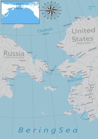
The Bering Strait is a strait between the Pacific and Arctic oceans, separating the Chukchi Peninsula of the Russian Far East from the Seward Peninsula of Alaska. The present Russia-United States maritime boundary is at 168° 58' 37" W longitude, slightly south of the Arctic Circle at about 65° 40' N latitude. The Strait is named after Vitus Bering, a Danish explorer in the service of the Russian Empire.

The Arctic Archipelago, also known as the Canadian Arctic Archipelago, is an archipelago lying to the north of the Canadian continental mainland, excluding Greenland and Iceland.

Wales is a city in the Nome Census Area, Alaska, United States. At the 2010 census the population was 145, down from 152 in 2000. It is the westernmost city on the North American mainland, although Adak, located on Adak Island, is the westernmost city in Alaska. Wales Airport serves Wales with flights on Bering Air and Ravn Alaska to Nome.
Naukati Bay is a census-designated place (CDP) in the Prince of Wales-Hyder Census Area of the Unorganized Borough of the U.S. state of Alaska. The population was 113 at the 2010 census, down from 135 in 2000.

This is a list of the extreme points of North America: the points that are highest and lowest, and farther north, south, east or west than any other location on the continent. Some of these points are debatable, given the varying definitions of North America.

The Alexander Archipelago is a 300-mile (480 km) long archipelago in North America lying off the southeastern coast of Alaska. It contains about 1,100 islands, the tops of submerged coastal mountains that rise steeply from the Pacific Ocean. Deep channels and fjords separate the islands and cut them off from the mainland. The islands shelter the northern part of the Inside Passage as it winds its way among them.

The Dixon Entrance is a strait about 80 kilometers (50 mi) long and wide in the Pacific Ocean at the Canada–United States border, between the U.S. state of Alaska and the province of British Columbia in Canada. The Dixon Entrance is part of the Inside Passage shipping route. It forms part of the maritime boundary between the U.S. and Canada, although the location of that boundary here is disputed.
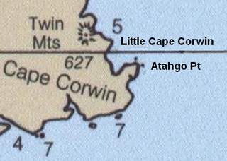
Cape Corwin is the easternmost point of Nunivak Island in the Bering Sea in the U.S. state of Alaska. In the Cup'ig language it is known as Cing'ig. According to Donald Orth the name marks the southwest entrance point to Etolin Strait. According to local usage the feature is misnamed on official United States Geological Survey maps. Since the name was reported to USGS by the USCGS in "about 1908" it may have subsequently migrated to the next northernmost point of land, Cing'ig. The 1911 USCGS chart does not accurately represent the shape of the coast here; the point and the cape are not separately identifiable. The USGS lists Atahgo Point, Valilief Cape, and Chingeleth Point as alternative names for Cape Corwin; Atahgo point also has its own listing with distinct coordinates.

Forrester Island Wilderness is a 2,832-acre (1,146 ha) wilderness area in the U.S. state of Alaska at Forrester Island. It was designated by the United States Congress in 1970. It is part of the Gulf of Alaska unit of the Alaska Maritime National Wildlife Refuge.

Kosciusko Island is an island in the Alexander Archipelago of southeastern Alaska, United States. It lies near the northwest corner of Prince of Wales Island, just across the El Capitan Passage from the larger island.
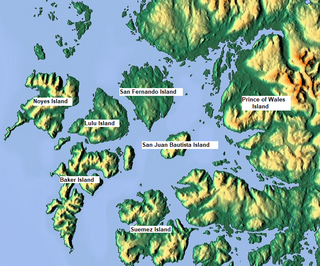
Suemez Island is located in the Alexander Archipelago of southeastern Alaska, United States. It resides in the west-central coast of Prince of Wales Island. The northern tip of Dall Island lies to its southeast, while Baker Island lies to its northwest. Suemez Island has a land area of 151.713 km2 and was unpopulated at the 2000 census.
Bucareli Bay is a bay in the Alexander Archipelago, in the southeastern part of the U.S. state of Alaska. It is located off the western coast of Prince of Wales Island, between Baker Island and Suemez Island. To the east it connects to various waterways, such as San Alberto Bay. To the west it opens directly upon the Pacific Ocean. Bucareli Bay is about 25 miles (40 km) long.

Heceta Island is an island in the Alexander Archipelago of southeastern Alaska, United States. It lies just off the west coast of Prince of Wales Island. Kosciusko Island lies to its north, while Tuxekan Island lies to its northeast. Directly to its south are the Maurelle Islands group, while further south are Noyes Island, Lulu Island, and San Fernando Island. The island's area is 181.0 km2.

Buldir Volcano is an inactive stratovolcano located on Buldir Island in the Aleutian Islands of Alaska, once described as "the westernmost volcanic center of the present Pleistocene to Recent Aleutian volcanic front." It shares the island with a younger stratovolcano named East Cape.

Cordova Bay is a bay in the Alexander Archipelago of southeast Alaska. It opens onto Dixon Entrance to the south, between Cape Muzon on Dall Island and Point Marsh. The name Puerto Cordova y Cordova was given by the Spanish explorer Lieutenant Don Jacinto Caamaño in 1792, in honor of Admiral Luis de Córdova y Córdova. The name was published by George Vancouver in 1798.

The borders of the oceans are the limits of Earth's oceanic waters. The definition and number of oceans can vary depending on the adopted criteria. The principal divisions of the five oceans are the Pacific Ocean, Atlantic Ocean, Indian Ocean, Southern (Antarctic) Ocean, and Arctic Ocean. Smaller regions of the oceans are called seas, gulfs, bays, straits, and other terms. Geologically, an ocean is an area of oceanic crust covered by water.

Noyes Island is located in the Alexander Archipelago of Southeast Alaska, United States. It is located west of Prince of Wales Island. It was named in 1879 by William Healy Dall of the United States Coast and Geodetic Survey after William M. Noyes, also of the USC&GS, who was stationed in Alaska from 1873 to 1880. The first European to notice the island was Aleksei Chirikov in 1741.

New Harbour is a bay about 10 miles (16 km) wide between Cape Bernacchi and Butter Point along the coast of Victoria Land, due west of Ross Island. It was discovered by the British National Antarctic Expedition (1901–04) and so named because this new harbor was found while the Discovery was seeking the farthest possible southern anchorage along the coast of Victoria Land. The Ferrar Glacier flows into the bay, which overlooked by Mount Barnes, which sits at the eastern end of the Kukri Hills range.

The Pacific Northwest coast of North America was one of the last coastlines reached by European explorers. In terms of sailing time from Europe, it was one of the most distant places on earth. This article covers what Europeans knew or thought they knew before the area was explored by Captain Cook in 1778.
