Related Research Articles

Bodega Bay is a shallow, rocky inlet of the Pacific Ocean on the coast of northern California in the United States. It is approximately 5 mi (8 km) across and is located approximately 40 mi (60 km) northwest of San Francisco and 20 mi (32 km) west of Santa Rosa. The bay straddles the boundary between Sonoma County to the north and Marin County to the south. The bay is a marine habitat used for navigation, recreation, and commercial and sport fishing.

The Alexander Archipelago is a 300-mile (480 km) long archipelago in North America lying off the southeastern coast of Alaska. It contains about 1,100 islands, the tops of submerged coastal mountains that rise steeply from the Pacific Ocean. Deep channels and fjords separate the islands and cut them off from the mainland. The islands shelter the northern part of the Inside Passage as it winds its way among them.

Juan Francisco de la Bodega y Quadra was a Spanish Criollo naval officer operating in the Americas. Assigned to the Pacific coast Spanish Naval Department base at San Blas, in Viceroyalty of New Spain, he explored the Northwest Coast of North America as far north as present day Alaska. Bodega Bay in California is named for him.

Juan Manuel de Ayala y Aranza was a Spanish Navy officer who played a significant role in the European exploration of California, as he and the crew of his ship San Carlos were the first Europeans known to have entered the San Francisco Bay, having sailed there from the Port of San Blas, Nayarit, Mexico.

Antonio María de Bucareli y Ursúa was a Spanish military officer, governor of Cuba, and Viceroy of New Spain from 1771 until his death in 1779. His military service included campaigns in Italy and Portugal. He rose to the rank of lieutenant general while serving as inspector of coastal fortifications in Granada. In 1766, Bucareli entered the Spanish colonial administration as governor and captain general of Cuba. His record there earned him appointment as viceroy of New Spain in 1771.
Juan José Pérez Hernández, often simply Juan Pérez, was an 18th-century Spanish explorer. He was the first known European to sight, examine, name, and record the islands near present-day British Columbia, Canada. Born in Palma de Mallorca, Spain, he first served as a piloto in western Spanish colonial North America on Manila galleons en route to and from the Philippines in the Spanish East Indies. In 1768, he was assigned to the Pacific port of San Blas, in the Viceroyalty of New Spain, and acquired the rank of ensign (alférez).
Bruno de Heceta (Hezeta) y Dudagoitia (1743–1807) was a Spanish Basque explorer of the Pacific Northwest. Born in Bilbao of an old Basque family, he was sent by the viceroy of New Spain, Antonio María Bucareli y Ursúa, to explore the area north of Alta California in response to information that there were colonial Russian settlements there.
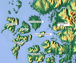
Suemez Island is located in the Alexander Archipelago of southeastern Alaska, United States. It resides in the west-central coast of Prince of Wales Island. The northern tip of Dall Island lies to its southeast, while Baker Island lies to its northwest. Suemez Island has a land area of 151.713 km2 and was unpopulated at the 2000 census.

Sonora Island is one of the outer islands of the Discovery Islands of British Columbia, Canada. It is located at the eastern end of Johnstone Strait and the northern end of Discovery Passage within Electoral Area C of the Strathcona Regional District.
During the Age of Discovery, the Spanish Empire undertook several expeditions to the Pacific Northwest of North America. Spanish claims to the region date to the papal bull of 1493, and the Treaty of Tordesillas signed in 1494. In 1513, this claim was reinforced by Spanish explorer Vasco Núñez de Balboa, the first European to sight the Pacific Ocean, when he claimed all lands adjoining this ocean for the Spanish Crown. Spain only started to colonize the claimed territory north of present-day Mexico in the 18th century, when it settled the northern coast of Las Californias.
Francisco de Eliza y Reventa was a Spanish naval officer, navigator, and explorer. He is remembered mainly for his work in the Pacific Northwest. He was the commandant of the Spanish post in Nootka Sound on Vancouver Island, and led or dispatched several exploration voyages in the region, including the Strait of Juan de Fuca and the Strait of Georgia.

The history of the Tlingit includes pre- and post-contact events and stories. Tradition-based history involved creation stories, the Raven Cycle and other tangentially-related events during the mythic age when spirits transformed back and forth from animal to human and back, the migration story of arrival at Tlingit lands, and individual clan histories. More recent tales describe events near the time of the first contact with Europeans. European and American historical records come into play at that point; although modern Tlingit have access to those historical records, however, they maintain their own record of ancestors and events important to them against the background of a changing world.

Francisco Antonio Mourelle de la Rúa was a Spanish naval officer and explorer from Galicia serving the Spanish crown. He was born in 1750 at San Adrián de Corme, near A Coruña, Galicia.

La Princesa was a Spanish frigate or corvette built at the Spanish naval base at San Blas and launched in 1778. She is sometimes called a frigate and sometimes a corvette. At the time a corvette was similar to a frigate in that both were three-masted, ship-rigged warships, but corvettes were slightly smaller and had a single deck instead of two. The exact specifications of La Princesa are not known. La Princesa was designed with storage enough to sail for a year without having to restock. She was built for durability rather than speed. Like La Favorita, a similar corvette stationed at San Blas, La Princesa was heavily used, serving for over three decades, playing an important role in the exploration of the Pacific Northwest as well as the routine work of provisioning the missions of Alta California. During her 1779 voyage the Princesa carried six four-pounder cannons and four three-pounders, and had a crew complement of 98. The Princesa carried 26 cannons in 1789 when Esteban José Martínez took control of Nootka Sound.
Ignacio de Arteaga y Bazán was an officer of the Spanish Navy.
Port Etches is a bay in the southcentral part of the U.S. state of Alaska. It is located on the west side of Hinchinbrook Island and opens onto Hinchinbrook Entrance, a strait between Hinchinbrook Island and Montague Island, connecting Prince William Sound and the Gulf of Alaska.
Sutil was a brig-rigged schooner built in 1791 by the Spanish Navy at San Blas, New Spain. It was nearly identical to Mexicana, also built at San Blas in 1791. Both vessels were built for exploring the newly discovered Strait of Georgia, carried out in 1792 under Dionisio Alcalá Galiano, on Sutil, and Cayetano Valdés y Flores, on Mexicana. During this voyage the two Spanish vessels encountered the two British vessels under George Vancouver, HMS Discovery and HMS Chatham, which were also engaged in exploring the Strait of Georgia. The two expeditions cooperated in surveying the complex channels between the Strait of Georgia and Queen Charlotte Strait, in the process proving the insularity of Vancouver Island. After this first voyage Sutil continued to serve the San Blas Naval Department, making various voyages to Alta California and the Pacific Northwest coast.
Sealion Cove is a cove off the Pacific Ocean in northwestern Kruzof Island in Southeast Alaska. It is accessible by boat from the Pacific Ocean or by trail from Kalinin Bay off of Salisbury Sound. It is about 40 km Northwest of Sitka and within the city's limits.

The Boca de Quadra is a bay extending southwest from the Keta River to Revillagigedo Channel in Southeastern Alaska. It is located almost entirely within Misty Fjords National Monument.
North West America was a British merchant ship that sailed on maritime fur trading ventures in the late 1780s. It was the first non-indigenous vessel built in the Pacific Northwest. In 1789 it was captured at Nootka Sound by Esteban José Martínez of Spain during the Nootka Crisis, after which it became part of the Spanish Navy and was renamed Santa Gertrudis la Magna and later Santa Saturnina.
References
- 1 2 U.S. Geological Survey Geographic Names Information System: Bucareli Bay
- 1 2 Olson, Wallace M. (2002), "The Hezeta Expedition of 1775: Selections from the journals of: Bodega y Quadra, Mourelle", Through Spanish Eyes: Spanish Voyages to Alaska, 1774-1792 (Limited ed.), Auke Bay, Alaska: Heritage Research, p. 46, ISBN 0-9659009-1-6
- ↑ About Alaska's Volcanoes, Alaska Volcano Observatory
| International | |
|---|---|
| National | |
55°22′12″N133°24′14″W / 55.37000°N 133.40389°W
| | This article about a location in the Prince of Wales–Hyder Census Area, Alaska is a stub. You can help Wikipedia by expanding it. |