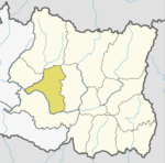
Khotang District is one of 14 districts of Province No. 1 of eastern Nepal. The district, with Diktel as its district headquarters, covers an area of 1,591 km2 (614 sq mi) and has a population (2011) of 206,312. The district has been bordered by Bhojpur District in the east, Udayapur district in the south, Okhaldhunga district in the west and Solukhumbu district in the North.
Solukhumbu District (Nepali: सोलुखुम्बु जिल्ला [solukʰumbu], Sherpa: ཤར་ཁུམ་བུ་རྫོང་ཁ།, Wylie: shar khum bu dzong kha) is one of 14 districts of Province No. 1 of eastern Nepal. As the name suggests, it consists of the subregions Solu and Khumbu.

Solududhkunda (earlier:Dudhkunda) is the only municipality of Solukhumbu District. Located in Province No. 1 of Nepal. The town of Salleri, which is located within the municipality is the headquarter of Solukhumbu District It was formed in 2014 by merging four VDCs: Salleri, Garma, Loding Tamakhani and Beni and was divided into 9 wards. Total area of the municipality had 254.3 square kilometres (98.2 sq mi) and population of municipality had 20,399 individuals living in 5,368 households.

A Village Development Committee (VDC) in Nepal was the lower administrative part of its Ministry of Federal Affairs and Local Development. Each district had several VDCs, similar to municipalities but with greater public-government interaction and administration. There were 3,157 village development committees in Nepal. Each VDC was further divided into several wards depending on the population of the district, the average being nine wards.

Patarasi is a rural municipality located in Jumla District of Karnali Province of Nepal.

Bahunidanda is a town in Halesi Tuwachung municipal area in Khotang District of Province No. 1 of eastern Nepal. At the time of the 1991 Nepal census it had a population of 2,365 persons living in 401 individual households.
Dipsung is a village and Village Development Committee in Khotang District in the Sagarmatha Zone of eastern Nepal. At the time of the 1991 Nepal census, it had a population of 950 living in 205 individual households.
Kharmi is a town and Village Development Committee in Khotang District in the Sagarmatha Zone of eastern Nepal. At the time of the 1991 Nepal census it had a population of 3,807 persons living in 723 individual households.
Khotang Bazar is a village and Village Development Committee in Khotang District in Province No. 1 in eastern Nepal. At the time of the 1991 Nepal census, it had a population of 2,433 persons living in 458 individual households.....
Salle is a village and Haleshi Tuwachung Municipality Ward No.9 (Nepal) in Khotang District in the Sagarmatha Zone of eastern Nepal. At the time of the 1991 Nepal census it had a population of 1,931 persons living in 357 individual households.
Sungdel is a village and Village Development Committee in Khotang District in the Sagarmatha Zone of eastern Nepal. At the time of the 1991 Nepal census it had a population of 2,846 persons living in 585 individual households. Its situated at northern east belt of khotang district. Currently, there is a high school, Shree surya Ma. Vi, and four other primary schools as means of education. Peoples running their own hydropower.Mojority of people are Koyee Rai. It is the only one place where Koyee people speaks their mothertone language Koyee. This language is also known as sungdele bhasa. Most of people depends on farming.The highest hill in khotang district Loure is situated in Sungdel. Sungdel is famous for wild bee honey.
Khandadevi is a populated place and a ward of Khandadevi Rural Municipality. It was a village development committee before 10 March 2017. At the time of the 1991 Nepal census it had a population of 3751 people living in 650 individual households.

Khotehang is a rural municipality (gaunpalika) in Khotang District of Province No. 1 of Nepal.
Diprungchuichumma(Nepali: दिप्रुङ चुईचुम्मा गाउँपालिका) is a rural municipality (gaunpalika) out of eight rural municipality located in Khotang District of Province No. 1 of Nepal. There are a total of 10 municipalities in Khotang in which 2 are urban and 8 are rural.
Aiselukharka is a rural municipality (gaunpalika) out of eight rural municipality located in Khotang District of Province No. 1 of Nepal. There are a total of 10 municipalities in Khotang in which 2 are urban and 8 are rural.
Jantedhunga is a rural municipality (gaunpalika) out of eight rural municipality located in Khotang District of Province No. 1 of Nepal. There are a total of 10 municipalities in Khotang in which 2 are urban and 8 are rural.
Kepilasgadhi is a rural municipality (gaunpalika) out of eight rural municipality located in Khotang District of Province No. 1 of Nepal. There are a total of 10 municipalities in Khotang in which 2 are urban and 8 are rural.

Barahapokhari is a rural municipality (gaunpalika) out of eight rural municipality located in Khotang District of Province No. 1 of Nepal. There are a total of 10 municipalities in Khotang in which 2 are urban and 8 are rural.
Rawabesi is a rural municipality (gaunpalika) in Khotang District of Province No. 1 of Nepal.
Sakela is a rural municipality (gaunpalika) out of eight rural municipality located in Khotang District of Province No. 1 of Nepal. There are a total of 10 municipalities in Khotang in which 2 are urban and 8 are rural.