Kyrgyzstan, officially the Kyrgyz Republic, is a landlocked country in eastern Central Asia, lying in the Tian Shan and Pamir mountain ranges. Bishkek is the capital and largest city. Kyrgyzstan is bordered by Kazakhstan to the north, Uzbekistan to the west, Tajikistan to the south, and China to the east and southeast. Ethnic Kyrgyz make up the majority of the country's over 7 million people, followed by significant minorities of Uzbeks and Russians.

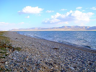
Issyk-Kul or Ysyk-Köl is an endorheic saline lake in the western Tianshan Mountains in eastern Kyrgyzstan, just south of a dividing range separating Kyrgyzstan from Kazakhstan. It is the eighth-deepest lake in the world, the eleventh-largest lake in the world by volume, the deepest lake whose deepest point is above sea level, and the third-largest saline lake. Issyk-Kul means "warm lake" in the Kyrgyz language; although it is located at a lofty elevation of 1,607 metres (5,272 ft) and subject to severe cold during winter, it rarely freezes over due to high salinity.

Issyk-Kul Region is one of the regions of Kyrgyzstan. Its capital is Karakol. It is surrounded by Almaty Region, Kazakhstan (north), Chüy Region (west), Naryn Region (southwest) and Xinjiang, China (southeast). It takes its name from Lake Issyk-Kul, the world's second-largest high altitude lake. Its total area is 43,735 km2 (16,886 sq mi). The resident population of the region was 501,933 as of January 2021. The region has a sizeable Russian minority.

Cholpon-Ata is a resort town on the northern shore of Lake Issyk-Kul in Kyrgyzstan with a population of 14,237 (2021). It is the administrative center of the Issyk-Kul District of Issyk-Kul Region; this district occupies most of the lake's north shore. To the west along highway A363 is Tamchy and to the east, Bosteri.

Barskoon is a settlement on the southern shore of Lake Issyk Kul in the Issyk-Kul Region of Kyrgyzstan. Its population was 9,040 in 2021. It is on the A363 highway between Bökönbaev to the west and Kyzyl-Suu to the east.

Although Kyrgyzstan’s mountains and lakes are an attractive tourist destination, the tourism industry has grown very slowly because it has received little investment. In the early 2000s, an average of about 450,000 tourists visited annually, mainly from countries of the former Soviet Union. In 2018, the British Backpacker Society ranked Kyrgyzstan as the fifth best adventure travel destination on earth, stating that the country was an adventure travel secret that is "bound to get out soon."

Song-Köl is an alpine lake in northern Naryn Region, Kyrgyzstan. It lies at an altitude of 3016 m, and has an area of about 270 km2 and volume of 2.64 km3. The lake's maximum length is 29 km, breadth about 18 km at its widest, and the deepest point is 13.2 m. It is the second largest lake in Kyrgyzstan after Issyk-Kul, and the largest fresh water lake in the country.

Kosh-Köl is a village in the Issyk-Kul Region of Kyrgyzstan. The village name has also been transliterated as Kosh-Kël' or Kosh-Kel'. It is part of the Issyk-Kul District. Its population was 588 in 2021.

Chok-Tal is a village in the Issyk-Kul District of the Issyk-Kul Region of Kyrgyzstan. Its population was 1,910 in 2021. It is located on the northern shore of Lake Issyk Kul between Tamchy and Cholpon Ata.

Anan'yevo is a village in the Issyk-Kul Region of Kyrgyzstan. It is part of the Issyk-Kul District. Its population was 9,362 in 2021. Located on highway A363 on the north shore of Lake Issyk Kul, the next town to the west is Semyonovka, and to the east, Tüp. It was founded in 1871 as Sazonovka settlement and there is still a significant Russian population. In 1942, the village was renamed after one of the Panfilov's Twenty-Eight Guardsmen - Nikolay Yakovlevich Anan'yev, who was born in Sazonovka in 1912. There are a church and a mosque in the village.

Kochkor is a large village in northern Naryn Region of Kyrgyzstan. It is the administrative centre of Kochkor District. The village was established in 1909 as Stolypino and renamed to Kochkor in 1917. Altitude 1,800 m. Its population was 11,373 in 2021. It is on the main A365 highway from Torugart Pass (China) north to Bishkek. About 7 km west A367 branches west toward Jalal-Abad Region and the Ferghana Valley. About 25 km northeast along the highway is the Orto-Tokoy reservoir and about 45 km northeast is Balykchy on Lake Issyk-Kul. The village is a base for excursions into the high country and tourist infrastructure is fairly well developed. There is a regional museum.

Issyk-Kul District is a district of Issyk-Kul Region in north-eastern Kyrgyzstan. The seat lies at Cholpon-Ata. Its area is 3,603 square kilometres (1,391 sq mi), and its resident population was 84,876 in 2021.

Jeti-Ögüz is a balneotherapic resort located at the Jeti-Ögüz Rocks near Issyk Kul in the Jeti-Ögüz District of Issyk-Kul Region of Kyrgyzstan, about 28 km west of Karakol, and near Jeti-Ögüz village. Its population was 337 in 2021.

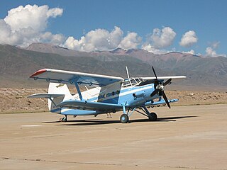
Issyk-Kul International Airport is an international airport near Tamchy, a village in Issyk Kul District of Issyk Kul Region (oblast) of Kyrgyzstan. The Russian IATA code for Issyk-Kul International Airport is ИКУ.

The Kökömeren is a right tributary of the Naryn located in Chüy Region and Naryn Region of Kyrgyzstan. It is formed by the confluence of the rivers Suusamyr and Batysh Karakol. It is 199 kilometres (124 mi) long, and has a drainage basin of 10,400 square kilometres (4,000 sq mi), with an average discharge of 80.3 cubic metres per second (2,840 cu ft/s). It possesses significant hydro-power potential. In June 2011, China and Kyrgyzstan signed a protocol of intent to begin construction of Kökömeren River chain of power plants in 2012. Whitewater rafting and fishing are popular tourist activities on the Kökömeren.
Tamga Airport is a small airport serving Jeti-Ögüz District in Issyk-Kul Region (oblast) of Kyrgyzstan. The Russian IATA code for the airport is ТМГ.
Cholpon-Ata Airport is an airport serving the resort town of Cholpon-Ata in the Issyk Kul Province (oblast) of Kyrgyzstan. The Russian IATA code for Cholpon-Ata Airport is ЧЛА.

The Independence Day of Kyrgyzstan is the main state holiday in Kyrgyzstan. It is celebrated in Kyrgyzstan annually on August 31, the anniversary of its declaration of independence in 1991.

The Kyrgyz Ground Forces, also commonly known as the Kyrgyz Army is the land force branch of the Armed Forces of the Republic of Kyrgyzstan.

The Rukh Ordo is a cultural complex and open-air museum in Cholpon-Ata, Kyrgyzstan. The name of the complex means in Kyrgyz, "The Spirits' Center". The cultural complex is located near the shore of Issyk-Kul Lake and occupies 4.5 hectares.


