Balé Province

Last updated • 1 min readFrom Wikipedia, The Free Encyclopedia
Balé
Province
Burkina Faso - Bale.svg
Location in Burkina Faso
Bale departments.png
Provincial map of its departments
Country Flag of Burkina Faso.svg  Burkina Faso
Region Boucle du Mouhoun
Capital Boromo
Area
  Province4,596 km2 (1,775 sq mi)
Population
 (2019 census) [1]
  Province297,367
  Density65/km2 (170/sq mi)
   Urban
20,193
Time zone UTC+0 (GMT 0)

Balé is one of the 45 provinces of Burkina Faso, located in its Boucle du Mouhoun Region with Boromo as capital. Its area is 4,596 km2 (1,775 sq mi), and had a population of 297,367 in 2019. The province is known for its Deux Balé Forest, populated by savannah elephant herds. Boromo, the provincial capital, is located on the main road from Ouagadougou to Bobo-Dioulasso. In June 2007, the Canadian mining company, Semafo, open the third gold mine in the country in Mana in the province, with an investment of about $116 million.

Contents

History

On November 15, 2008 a bus accident killed 69 people at Boromo. [2] When a passenger bus transporting workers to Côte d'Ivoire collided with a commercial truck. Both vehicles burst into flames. [3]

Geography

The province is known for its Deux Balé Forest, populated by savannah elephant herds. [4] Boromo, the provincial capital, is located on the main road from Ouagadougou to Bobo-Dioulasso, [5] and serves as a gateway to the park. [6]

Demographics

Most people in the province live in rural areas; 277,165 live in the countryside with only 20,202 people residing in urban areas. There are 147,993 men living in Balé Province and 149,374 women. [1]

Departments

Bale is divided into 10 departments:

The Departments of Bale
DepartmentCapital cityPopulation
(Census 2006) [7]
Bagassi Department Bagassi 33,130
Bana Department Bana 12,999
Boromo Department Boromo 30,305
Fara Department Fara 37,194
Oury Department Oury 26,892
Pâ Department Pa 19,675
Pompoi Department Pompoi 11,060
Poura Department Poura 12,075
Siby Department Siby 14,143
Yaho Department Yaho 16,424

Economy and services

In June 2007, the Canadian mining company, Semafo, open the third gold mine in the country in Mana, with an investment of about $116 million. [8] There is a hydroelectric station at Boromo, operated by the Société Nationale d'électricité du Burkina Faso (SONABEL) with 1,269 MWh. [9] [10]

In 2011 the province had 164 primary schools and 22 secondary schools. [11]

In 2011 the province had 31 health and social promotion centers (Centres de santé et de promotion sociale), 4 doctors and 115 nurses. [11]

See also

Related Research Articles

<span class="mw-page-title-main">Geography of Burkina Faso</span>

Burkina Faso is a landlocked Sahel country that shares borders with six nations. It lies between the Sahara desert and the Gulf of Guinea, south of the loop of the Niger River, mostly between latitudes 9° and 15°N, and longitudes 6°W and 3°E. The land is green in the south, with forests and fruit trees, and semi-arid in the north. Most of central Burkina Faso lies on a savanna plateau, 198–305 metres (650–1,001 ft) above sea level, with fields, brush, and scattered trees. Burkina Faso's game preserves – the most important of which are Arly, Nazinga, and W National Park—contain lions, elephants, hippopotamus, monkeys, common warthogs, and antelopes. Previously the endangered painted hunting dog, Lycaon pictus occurred in Burkina Faso, but, although the last sightings were made in Arli National Park, the species is considered extirpated from Burkina Faso.

<span class="mw-page-title-main">Bobo-Dioulasso</span> City in Houet Province, Burkina Faso

Bobo-Dioulasso is a city in Burkina Faso with a population of 1,129,000 ; it is the second-largest city in the country, after Ouagadougou, Burkina Faso's capital. The name means "home of the Bobo-Dioula".

<span class="mw-page-title-main">Provinces of Burkina Faso</span> Subdivisions of Burkina Faso

The regions of Burkina Faso are divided into 45 administrative provinces. These 45 provinces are currently sub-divided into 351 departments or communes.

<span class="mw-page-title-main">Kossi Province</span> Province in Boucle du Mouhoun, Burkina Faso

The Province de la Kossi lies in the western part of Burkina Faso and stretches to the border with Mali. It is in the Boucle du Mouhoun Region. The capital of Kossi is the town of Nouna, which has a mayor and high commissioner. The next largest town in Kossi is Djibasso, the last major town on the road from Nouna that heads west into Mali.

<span class="mw-page-title-main">Departments of Burkina Faso</span> Administrative division and commune of Burkina Faso

The provinces of Burkina Faso are divided into 351 departments, whose urbanized areas are grouped into the same commune (municipality) with the same name as the department. The department also covers rural areas that are not governed locally by the elected municipal council of the commune, but by the state represented at departmental level by a prefect.

<span class="mw-page-title-main">Banwa Province</span> Province in Boucle du Mouhoun, Burkina Faso

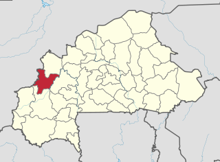
Banwa is one of the 45 provinces of Burkina Faso and is in Boucle du Mouhoun Region. The capital of Banwa is Solenzo. In 2019 it had a population of 345,749.

<span class="mw-page-title-main">Mouhoun Province</span> Province in Boucle du Mouhoun, Burkina Faso

Mouhoun is one of the 45 provinces of Burkina Faso. It is in the Boucle du Mouhoun region. The capital of Mouhoun is Dédougou.

<span class="mw-page-title-main">Nayala Province</span> Province in Boucle du Mouhoun, Burkina Faso

Nayala is one of the 45 provinces of Burkina Faso and is in Boucle du Mouhoun Region.

<span class="mw-page-title-main">Sourou Province</span> Province in Boucle du Mouhoun, Burkina Faso

Sourou is one of the 45 provinces of Burkina Faso, located in its Boucle du Mouhoun.

<span class="mw-page-title-main">Boucle du Mouhoun Region</span> Region of Burkina Faso

Boucle du Mouhoun is one of Burkina Faso's 13 administrative regions. It was created on 2 July 2001 and had a population of 1,898,133 in 2019. It is the 4th most populous region in Burkina Faso, and contains 9.26% of all Burkinabé. The region's capital is Dédougou. Six provinces make up the Boucle du Mouhoun region—Balé, Banwa, Kossi, Mouhoun, Nayala, and Sourou.

<span class="mw-page-title-main">Centre-Ouest Region</span> Region of Burkina Faso

Centre-Ouest is one of Burkina Faso's 13 administrative regions. The population of Centre-Ouest was 1,659,339 in 2019. The region's capital is Koudougou. Four provinces make up the region.

<span class="mw-page-title-main">Boromo</span> Town in Boucle du Mouhoun Region, Burkina Faso

Boromo is a town in the Boromo Department of Balé Province in Burkina Faso. It is the capital of both the department and the province, and it has a population of 20,193 (2019).

<span class="mw-page-title-main">Tourism in Burkina Faso</span>

According to the Government of Burkina Faso, 433,778 tourists visited the country in 2011.

Articles related to Burkina Faso include:

<span class="mw-page-title-main">Boromo Department</span> Department in Balé, Burkina Faso

Boromo is a department of Balé Province in southern Burkina Faso. Its capital is the town of Boromo. According to the 2019 census the department has a population of 40,228.

<span class="mw-page-title-main">Fara Department</span> Department in Balé, Burkina Faso

Fara is a department or commune of Balé Province in southern Burkina Faso. Its capital is the town of Fara. According to the 2019 census the department has a population of 60,972.

<span class="mw-page-title-main">Subdivisions of Burkina Faso</span> List of subdivisions of Burkina Faso

Burkina Faso is divided into thirteen regions, forty-five provinces, and 351 departments.

The following is a timeline of the history of the city of Ouagadougou, Burkina Faso.

<span class="mw-page-title-main">Koumbia, Tuy, Burkina Faso</span> Town in Hauts-Bassins, Burkina Faso

Koumbia is a town in southwestern Burkina Faso, capital of the rural municipality and Department of Koumbia in Tuy Province. It is situated about 70 km east of Bobo-Dioulasso along the trunk road Route nationale N1 to Ouagadougou where the Route régionale R25 joins the N1.

References

  1. 1 2 Citypopulation.de Population of provinces in Boucle du Mouhoun Region
  2. Rupley, Lawrence; Bangali, Lamissa; Diamitani, Boureima (2013). Historical Dictionary of Burkina Faso. Rowman & Littlefield. p. 72. ISBN   978-0-8108-6770-3.
  3. Encyclopædia Britannica Almanac 2010. Encyclopædia Britannica, Inc. 1 January 2010. p. 33. ISBN   978-1-61535-329-3.
  4. "Program "My Elephant Neighbor" Final Report – June 2011" (PDF). Elephantconservation.org. Retrieved 16 October 2016.
  5. Google Maps. Retrieved 16 October 2016.
  6. Ham, Anthony (2009). West Africa. Lonely Planet. p. 147. ISBN   978-1-74104-821-6.
  7. "2006 census" (PDF). Archived from the original (PDF) on 24 November 2007. Retrieved 16 October 2016.
  8. West Africa Development and Business Opportunities Handbook Volume 1. IBP, Inc. 7 February 2007. p. 74. ISBN   978-1-4330-5912-4.
  9. Obuobie, Marloes Mul, Emmanuel; Appoh, Richard; Yeboah, Kwabena Kankam- (1 February 2015). Water Resources Assessment of the Volta River Basin. IWMI. p. 39. ISBN   978-92-9090-829-6.{{cite book}}: CS1 maint: multiple names: authors list (link)
  10. "Boromo". CARMA. Retrieved 16 October 2016.
  11. 1 2 "La région du Boucle du Mouhoun en chiffres" (PDF). Institut National de la Statistique et de la Démographie (INSD). 2011. p. 6. Archived from the original (PDF) on 13 November 2012.

11°42′N3°10′W / 11.700°N 3.167°W / 11.700; -3.167