
Lake Balaton is a freshwater rift lake in the Transdanubian region of Hungary. It is the largest lake in Central Europe, and one of the region's foremost tourist destinations. The Zala River provides the largest inflow of water to the lake, and the canalized Sió is the only outflow.
Siófok is a town in Somogy County, Hungary on the southern bank of Lake Balaton. It is the second largest municipality in Somogy County and the seat of Siófok District. It covers an area of about 124.66 km2 between Lake Balaton, the Mezőföld and the Outer Somogy-Hills. Lying at the firth of the Sió Channel, it serves as the most important logistic station for goods between Lake Balaton and the River Danube.

Upper Hungary is the usual English translation of Felvidék, the Hungarian term for the area that was historically the northern part of the Kingdom of Hungary, now mostly present-day Slovakia. The region has also been called Felső-Magyarország.
The Rainwater Basin wetland region is a 4,200 sq mi (11,000 km2) loess plain located south of the Platte River in south-central Nebraska. It lies principally in Adams, Butler, Clay, Fillmore, Hamilton, Kearney, Phelps, Polk, Saline, Seward, and York counties and extends into adjacent areas of southeastern Hall, northern Franklin, northern Nuckolls, western Saline, northern Thayer and northwestern Webster counties. Before European settlement, this plain was covered by prairie grasslands interspersed with thousands of ephemeral playa wetlands, called Rainwater Basins. Informally and locally, individual Nebraska Rainwater Basins are referred to as rainbasins, basins, lagoons, lakes, ponds, marshes, hay marshes, and lakes marshes. To the west, a tallgrass prairie in the east once gradually transitioned into mixed grass prairie. Currently, the Rainwater Basin wetland region is covered by farms, mainly growing corn and soybeans. Several, interspersed, stream courses, of which largest is the Big Blue River and its tributaries, drain this region. Riparian woodlands and upland slopes possessing oak woodlands are associated with these streams. In the spring and fall months, millions of migratory birds pass through the region to feed and rest. Along with riparian habitats associated Platte River, Big Blue River, its tributaries, and smaller streams, Rainwater Basins are a major component of the Central Flyway of North America.

The Boreal Shield Ecozone, as defined by the Commission for Environmental Cooperation (CEC), is the largest ecozone in Canada. Covering 1.8 million square kilometres it covers almost 20% of Canada's landmass, stretching from northern Saskatchewan to Newfoundland.

The geology of Minnesota comprises the rock, minerals, and soils of the U.S. state of Minnesota, including their formation, development, distribution, and condition.

Tolay Lake is a shallow freshwater lake in southern Sonoma County, California, United States. The lake, nestled within the southern vestiges of the Sonoma Mountains, is the site of significant Native American prehistoric seasonal settlement. In 2005, Sonoma County acquired the entirety of the lake and virtually its whole drainage basin from the Cardoza family for the sum of $18 million; the county's intention is to utilize the property as Tolay Lake Regional Park for ecological and archaeological preservation, as well as public use and enjoyment. Tolay Lake and its immediate drainage area is home to several nesting pairs of golden eagles, Aquila chrysaetos, and a number of rare, threatened or endangered species including the California red-legged frog, Rana draytonii; Western pond turtle, Actinemys marmorata; and Western burrowing owl, Athene cunicularia.

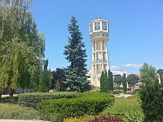
Szigliget is a village in Veszprém county, Hungary.
Lake Galilee is a semi-arid salt lake in the locality of Galilee, Barcaldine Region, within the Desert Uplands area of Central West Queensland, Australia. The lake is about 36 kilometres long, up to 12.5 kilometres wide and covers approximately 25,700 hectares.

The Boreal Plains Ecozone, as defined by the Commission for Environmental Cooperation (CEC), is a terrestrial ecozone in the western Canadian provinces of Manitoba, Saskatchewan and Alberta. It also has minor extensions into northeastern British Columbia and south-central Northwest Territories. The region extends over 779,471 km2, of which 58,981 km2 is conserved.

Protected areas of Poland include the following categories, as defined by the Act on Protection of Nature of 16 April 2004, by the Polish Parliament:

The Paroo-Darling National Park is a protected national park that is located in the Far West region of New South Wales, in eastern Australia. The 178,053-hectare (439,980-acre) national park spans two distinct regions in the outback area. This region covers the arid catchments of the Paroo River and the Paroo-Darling confluence to the south.
Badacsony wine region is located in central Transdanubia, on the Northern shores of Lake Balaton, around mount Badacsony. Its area is approximately 1600 hectares.

The Blue Lake is one of only four cirque lakes found in mainland Australia. The other three, Cootapatamba, Albina, and Club, are shallower and are held entirely by terminal moraines. Blue Lake's valley contains the best-developed glacial features in the Kosciuszko National Park alpine area of New South Wales. It was recognised as a wetland of international importance on 17 March 1996 when a 320-hectare (790-acre) area, comprising the lake and its surrounds, including nearby Hedley Tarn, was designated Ramsar Site 800 under the Ramsar Convention on wetlands. The lake lies within the Australian Alps National Parks and Reserves.
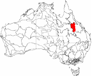
The Desert Uplands is an interim Australian bioregion located in north and central western Queensland which straddles the Great Dividing Range between Blackall and Pentland.

Meshchyorsky National Park covers extensive wetlands and pine/birch woodlands in the Meshchera Lowlands on the East European Plain in the northern section of Ryazan Oblast, Russia, about 120 km east of Moscow. The wetland habitat provides for extremely rich biodiversity among the plants and animals. "Meshchersky" (Мещёрский) National Park is not to be confused with "Meshchyora" (Мещёра) National Park, which is just to the north, over the border in Vladimir Oblast. The park protects a section of the Pra River, Lake Beloye, and associated wetlands and forests. About 54% of the park territory is used and managed for agricultural purposes by local communities.
Protected areas of Hungary includes 10 national parks, 35 landscape protection areas and 145 minor nature reserves. The national policy for governing and management of the protected areas is implemented by the Minister of Agriculture. The first national park in Hungary at the Great Hungarian Plain is Hortobágy National Park, established in 1973.
Armit Meadows Ecological Reserve is an ecological reserve located in Porcupine Provincial Forest, Manitoba, Canada. It was established in 2015 under the Manitoba Ecological Reserves Act. It is 2.63 square kilometres (1.02 sq mi) in size.

The Northeastern Highlands Ecoregion is a Level III ecoregion designated by the United States Environmental Protection Agency (EPA) in the U.S. states of Vermont, New Hampshire, Massachusetts, Maine, Connecticut, New York, New Jersey, and Pennsylvania. The ecoregion extends from the northern tip of Maine and runs south along the Appalachian Mountain Range into eastern Pennsylvania. Discontiguous sections are located among New York's Adirondack Mountains, Catskill Range, and Tug Hill. The largest portion of the Northeastern Highlands ecoregion includes several sub mountain ranges, including the Berkshires, Green Mountains, Taconic, and White Mountains.


