The Virgin Islands National Park is an American national park preserving about 60% of the land area of Saint John in the United States Virgin Islands, as well as more than 5,500 acres of adjacent ocean, and nearly all of Hassel Island, just off the Charlotte Amalie, Saint Thomas harbor.

Gros Islet District, one of 10 first order subdivision of the Caribbean island nation of Saint Lucia which includes the island's northernmost point, Cap Point and the notable Cap Estate, where the renowned St. Lucia Golf and Country Club is located. Whilst the town of Gros Islet is an important administrative centre, Rodney Bay is the main financial center of the district.

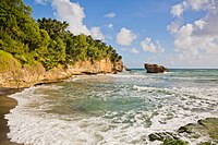
Vieux Fort is one of 10 districts of the Caribbean island country of Saint Lucia. Vieux Fort is also the name of the main town in the district. It is the home of the second-largest town in Saint Lucia and is the home of Saint Lucia's international airport, Hewanorra International Airport.

Dennery District is one of 10 districts of the Caribbean island nation of Saint Lucia. The seat of Dennery District is the Dennery Village. The main economic activities are fishing, and the cultivation of lima beans, bananas, and other tropical fruit. The population of the quarter was estimated at 12,876 in 2002 and fell to 12,767 in 2010.
Anse la Raye District is one of 10 districts of the island nation of St. Lucia in the Caribbean Sea. The name Anse la Raye is French for cover/bay of the rays, since there are a large number of skate fish or rays in the bay. In 2005/2010, the population of the district was 6,382/6,060 people, and they are mainly fishers and agricultural workers. The main town in the area takes the same name as the district and is located down the western coast from Castries, the capital of the country.
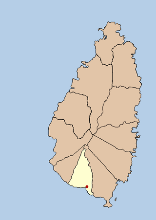
The island nation of Saint Lucia is divided into 10 districts. The name Quarters or Quartiers originally came from the French period in Saint Lucia. The 2001 and 2010 Census of Saint Lucia refers to the first level administrative divisions as districts. The FIPS and ISO standards regularly called these divisions quarters or quartiers in French. The former district of Dauphin Quarter was merged into Gros Islet District and the former district of Praslin Quarter was merged into Micoud District.
Choiseul District is one of the 10 districts of the Caribbean island nation of Saint Lucia. Located on the southwestern side of the island, the district is home to 6,130 people, according to the 2019 census. The seat of Choiseul District is the town of Choiseul.
Laborie District is one of 10 districts of the Caribbean island nation of Saint Lucia. According to the 2002 census, the population of the Quarter was 7,414 people. The village of Laborie is located about 27 km (17 mi) south of Castries, the nation's capital.
Laborie is a village on the south coast of Saint Lucia. It was originally called l'Islet a Caret after the Loggerhead sea turtles that were found in the area. The name Laborie is named after Baron de Laborie who was the French governor of Saint Lucia from 1784–1789. At that time the village had a population of 712. Laborie is the seat of the Laborie District.

Saint Lucia, an island nation in the Caribbean islands, has a relatively large tourism industry. Due to the relatively small land area of the country, most of the governmental promotion is performed by the state-operated Saint Lucia Tourism Authority, led by Executive Chairperson Agnes.

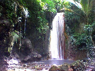
The Balembouche River is a coastal river in Laborie Quarter, Saint Lucia that flows into the Caribbean Sea.
Piaye is a community on the island of Saint Lucia; it is located on the southern coast, near Balembouche and Bongalo in the Laborie District, and shares its name with a nearby river. This community started as a small settlement of workers who laboured on the Balembouche estate. In the post-Balembouche period Piaye transformed into a community of fishermen, subsistence farmers and producers of hand-crushed aggregate for the construction industry.

Cinnamon Bay Plantation is an approximately 300-acre (1.2 km2) property situated on the north central coast of Saint John in the United States Virgin Islands adjacent to Cinnamon Bay. The land, part of Virgin Islands National Park, was added to the United States National Register of Historic Places on July 11, 1978. Archaeological excavations of the land document ceremonial activity of the Taínos, as well as historic remains of plantation ruins.

Reef Bay Sugar Factory Historic District is a historic section of Saint John, United States Virgin Islands located on the south central coast adjacent to Reef Bay. The land is the site of a sugar factory. The property was added to the U.S. National Register of Historic Places on July 23, 1981.
Soufrière Estate, located on the Caribbean island of Saint Lucia, was originally established in 1713 as a 2,000-acre (8.1 km2) estate granted to three Devaux brothers for services to King Louis XIV of France. Later on, mineral springs were discovered and were used as restorative baths by the French soldiers. In 1784, the Baron de Laborie, the French Governor of St Lucia, sent samples of the water to Paris for testing and it is believed to be good for rheumatism and skin complaints.

Bethlehem Old Work is a settlement on the island of Saint Croix in the United States Virgin Islands. It was set-up as one of the first plantations in the 1730s, and operated as the last sugar plantation on the island until the Bethlehem Central Factory closed in 1966.

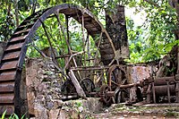
Sugar production in the United States Virgin Islands was an important part of the economy of the United States Virgin Islands for over two hundred years. Long before the islands became part of the United States in 1917, the islands, in particular the island of Saint Croix, was exploited by the Danish from the early 18th century and by 1800 over 30,000 acres were under cultivation, earning Saint Croix a reputation as the "Garden of the West Indies". Since the closing of the last sugar factory on Saint Croix in 1966, the industry has become only a memory.

The Estate Carolina Sugar Plantation near Coral Bay on Saint John, U.S. Virgin Islands is a historic sugar plantation and later rum distillery.
Trinity was a plantation in colonial Jamaica, located south of Port Maria, in Saint Mary Parish, one of several plantations owned by Zachary Bayly that formed part of the area known as Bayly's Vale. By the early nineteenth century, over 1,000 people were enslaved there producing mainly sugar and rum for which a mile-long aqueduct was built by Nathaniel Bayly to supply water for the refining process.

Albion was a sugar plantation in Saint David Parish, Jamaica. Created during or before the 18th century, it had at least 451 slaves when slavery was abolished in the British Empire in 1833. By the end of the 19th-century it was the most productive plantation in Jamaica due to the advanced refining technology it used. By the early 20th century, however, its cane sugar could not compete with cheaper European beet sugar, and it produced its last sugar crop in 1928. It subsequently became a banana farm for the United Fruit Company.