
Saint Lucia is an island country in the West Indies in the eastern Caribbean Sea on the boundary with the Atlantic Ocean. The island was previously called Iyonola, the name given to the island by the native Arawaks, and later Hewanorra, the name given by the native Caribs, two separate Amerindian peoples. Part of the Windward Islands of the Lesser Antilles, it is located north/northeast of the island of Saint Vincent, northwest of Barbados and south of Martinique. It covers a land area of 617 km2 and reported a population of 165,595 in the 2010 census. Its capital is Castries. Soufrière was colonized by the French and was the original capital of the island.

Saint Lucia is one of many small land masses composing the insular group known as the Windward Islands. Unlike large limestone areas such as Florida, Cuba, and the Yucatan Peninsula, or the Bahamas, which is a small island group composed of coral and sand, St. Lucia is a typical Windward Island formation of volcanic rock that came into existence long after much of the region had already been formed.

Dame Calliopa Pearlette Louisy is a former Governor-General of Saint Lucia. She was the first woman to hold this office, into which she was sworn on 19 September 1997, and resigned from on 31 December 2017.

Vieux Fort is one of 10 districts of the Caribbean island nation of Saint Lucia. Vieux Fort is also the name of the main town in the district. It is the home of the second-largest town in Saint Lucia and is the home of Saint Lucia's international airport, Hewanorra International Airport.

Dennery District is one of 10 districts of the Caribbean island nation of Saint Lucia. The seat of Dennery District is the Dennery Village. The main economic activities are fishing, and the cultivation of lima beans, bananas, and other tropical fruit. The population of the quarter was estimated at 12,876 in 2002 and fell to 12,767 in 2010.
Sir Allan Fitzgerald Laurent Louisy was the second prime minister of independent St Lucia, following Sir John Compton in office. He was born in Laborie on 5 September 1916 and served as a judge before being elected to parliament in 1974.
Anse la Raye District is one of 10 districts of the island nation of St. Lucia in the Caribbean Sea. The name Anse la Raye is French for cover/bay of the rays, since there are a large number of skate fish or rays in the bay. In 2005/2010, the population of the district was 6,382/6,060 people, and they are mainly fishers and agricultural workers. The main town in the area takes the same name as the district and is located down the western coast from Castries, the capital of the country.
The island nation of Saint Lucia is divided into 10 districts. The name Quarters or Quartiers originally came from the French period in Saint Lucia. The 2001 and 2010 Census of Saint Lucia refers to the first level administrative divisions as districts. The FIPS and ISO standards regularly called these divisions quarters or quartiers in French. The former district of Dauphin Quarter was merged into Gros Islet District and the former district of Praslin Quarter was merged into Micoud District.
Choiseul District is one of the 10 districts of the Caribbean island nation of Saint Lucia. Located on the southwestern side of the island, the district is home to 6,130 people, according to the 2019 census. The seat of Choiseul District is the town of Choiseul.
Laborie District is one of 10 districts of the Caribbean island nation of Saint Lucia. According to the 2002 census, the population of the Quarter was 7,414 people. The village of Laborie is located about 27 km (17 mi) south of Castries, the nation's capital.

Laborie is a village on the south coast of Saint Lucia. It was originally called l'Islet a Caret after the Loggerhead sea turtles that were found in the area. The name Laborie is named after Baron de Laborie who was the French governor of Saint Lucia from 1784–1789. At that time the village had a population of 712. Laborie is the seat of the Laborie District.
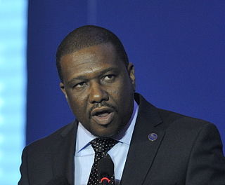
Alva Romanus Baptiste is a Saint Lucian politician who represents the constituency of Laborie for the Saint Lucia Labour Party. Baptiste won the seat at the general election held on 11 December 2006. He also won convincingly in the 2011, 2016 and 2021 general elections. He is currently the Minister for External Affairs, International Trade, Civil Aviation and Diaspora Affairs.

Babonneau is one of the regions of the Caribbean island nation of Saint Lucia. Babonneau is located in the north of the island in the Castries Quarter. There are extensive rain forests in the region, which is an important source of fresh water for Saint Lucia. Babonneau is also an electoral constituency of Saint Lucia represented in the House of Assembly of Saint Lucia, which extends into Gros Islet District.

The Balembouche River is a coastal river in Laborie Quarter, Saint Lucia that flows into the Caribbean Sea.

The Piaye River is a river in Laborie Quarter of the island nation of Saint Lucia.
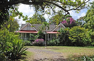
Balembouche is the original name of a historic 18th-century sugar plantation, Balenbouche Estate, which is now a guesthouse, designated heritage site and organic farm on the island of Saint Lucia. It is located on the south west coast of the island, near Bongalo and Piaye.
Laborie Football Club is a Saint Lucian football club based in the Laborie district, competing in the Saint Lucia Silver Division, the second tier of Saint Lucian football.
Saltibus is located on southwestern side of the Island of Saint Lucia. It belongs to one of two of the 11 quarters, or sections of the island, which were sometimes called "districts", which is no longer under control of the British colonial government as of 1979 AD. The village Saltibus is located northeast of the village of Choiseul, and northwest of the village of Laborie. It is located about 27 km south of Castries, the nation's capital. Saltibus is located in a rain-forest and is well known for its fresh running water and its rich fertile soil. There are a series of waterfalls with heights from 3 to 10 meters in the rain-forest. You could also find many rivers, cold springs and fresh stream. Saltibus has the main water dam which supplies water to the community and several neighboring communities. The economy is largely based on agriculture
The Mahaut River is a river in the Laborie Quarter of Saint Lucia. The mouth is at the Caribbean Sea.
