Quarters of Saint Lucia

Last updated
Districts of Saint Lucia since at least 2001 Saint Lucia, administrative divisions - fr - monochrome.svg
Districts of Saint Lucia since at least 2001

The island nation of Saint Lucia is divided into 10 districts (formerly called Quarters). The name Quarters or Quartiers originally came from the French period in Saint Lucia (Sainte Lucie in French). The 2001 and 2010 Census of Saint Lucia refers to the first level administrative divisions as districts. The FIPS and ISO standards regularly called these divisions quarters or quartiers in French. The former district of Dauphin Quarter was merged into Gros Islet District and the former district of Praslin Quarter was merged into Micoud District. [1] [2] [3] [4]

Contents

History

1758 map of Saint Lucia 1758 Bellin Map of Saint Lucia (Sainte Lucie), West Indies - Geographicus - SaintLucia-bellin-1758.jpg
1758 map of Saint Lucia

After the French claimed title of Saint Lucia in 1744, commandant de Rougueville divided Saint Lucia into districts and parishes. Quarters were administrative districts for the control of settlors and slaves. The French Surveyor General of Saint Lucia, M. Raussaim, initially divided Saint Lucia into seven quarters. [5]

In 1844, Henry Breen describes how Saint Lucia was divided into two districts, the eastern district on the leeward side of Saint Lucia facing the Atlantic Ocean and the western district on the windward side facing the Caribbean Sea. It was further divided into eleven quarters or parishes, i.e. Castries, Anse Laraye, Soufriere, Choiseul, Laborie, Vieux Fort, Micoud, Praslin, Dennery, Dauphin, and Gros-ilet. Each quarter or parish had a town in the coastal bay within its territory that was named the same as the quarter. Breen further talks about stipendiary magistrates introduced during the period of the apprenticeship system. [6] These magistrates were as follows:

  1. Castries, Gros-ilet, Daughpin, and Anse Laraye
  2. Soufriere, Choiseul, Laborie
  3. Vieux Fort, Micoud, Praslin, Dennery

Still later the number of stipendiary magistrates was increased to five:

  1. Castries and Anse Laray
  2. Gros-ilet and Sauphin
  3. Soufriere and Choiseul
  4. Vieux Fort and Laborie
  5. Micoud, Dennery, and Praslin

The magistrates did not survive. However, the quarters or parishes did survive, as such, with some mergers and changes in the names.

Districts

Since the 2001 Census of Saint Lucia there have been 10 districts in Saint Lucia. [3]

2010 Census Population and area of Saint Lucia Districts [1] [4]
#DistrictPopulation [1] Households [4] Land Area [1] Population density [1]
1 Anse la Raye 6,0602,17137.6 km2 (14.52 sq mi)161 per km2, 417 per mi2
2 Canaries 2,04478924.3 km2 (9.38 sq mi)84 per km2, 218 per mi2
3 Castries [7] 65,65623,296102.7 km2 (39.65 sq mi)639 per km2, 1,656 per mi2
4 Choiseul 6,1282,07725.9 km2 (10.00 sq mi)237 per km2, 612 per mi2
5 Dennery 12,7674,41972.3 km2 (27.93 sq mi)177 per km2, 457 per mi2
6 Gros Islet 20,8729,804100.3 km2 (38.73 sq mi)208 per km2, 539 per mi2
7 Laborie 7,3632,18933.8 km2 (13.05 sq mi)218 per km2, 564 per mi2
8 Micoud 16,2845,623112.1 km2 (43.29 sq mi)145 per km2, 376 per mi2
9 Soufrière 7,6572,88658.4 km2 (22.55 sq mi)131 per km2, 340 per mi2
10 Vieux Fort 14,7545,66549.8 km2 (19.22 sq mi)296 per km2, 768 per mi2
Saint Lucia165,59658,919617.00 km2 (238.23 sq mi)268 per km2, 695 per mi2

Notes

Dauphin Quarter Dauphin in Saint Lucia.svg
Dauphin Quarter
Praslin Quarter Praslin in Saint Lucia.svg
Praslin Quarter

Political divisions

Electoral boundaries of Saint Lucia Electoral boundaries of Saint Lucia.svg
Electoral boundaries of Saint Lucia

Saint Lucia electoral boudaries are based, generally, on the districts. There are 17 constituencies in Saint Lucia that are represented in the House of Assembly of Saint Lucia. A study was done in 2014 to look into variations in census and boudaries and possible expansion of the number of constituencies. [9] [10]

DistrictConstituency NamePopulation
Gros IsletGros Islet23242
Castries Babonneau 12,844
CastriesCastries East11782
CastriesCastries South9463
CastriesCastries Central7274
CastriesCastries South East14516
CastriesCastries North11463
Anse la Raye and CanariesAnse la Raye and Canaries8363
SoufrièreSoufrière8424
LaborieLaborie8588 [11]
Vieux FortVieux Fort North7201
Vieux FortVieux Fort South9336
MicoudMicoud North7173
MicoudMicoud South7330
DenneryDennery South4896
DenneryDennery North7570
ChoiseulChoiseul6130 [11]

See also

Related Research Articles

Saint Lucia Country in the West Indies in the eastern Caribbean Sea

Saint Lucia is an island country in the West Indies in the eastern Caribbean Sea on the boundary with the Atlantic Ocean. The island was previously called Iyonola, the name given to the island by the native Arawaks, and later Hewanorra, the name given by the native Caribs, two separate Amerindian peoples. Part of the Windward Islands of the Lesser Antilles, it is located north/northeast of the island of Saint Vincent, northwest of Barbados and south of Martinique. It covers a land area of 617 km2 and reported a population of 165,595 in the 2010 census. Its capital is Castries. Soufrière was colonized by the French and was the original capital of the island.

Geography of Saint Lucia Geography of the island country Saint Lucia

Saint Lucia is one of many small land masses composing the insular group known as the Windward Islands. Unlike large limestone areas such as Florida, Cuba, and the Yucatan Peninsula, or the Bahamas, which is a small island group composed of coral and sand, St. Lucia is a typical Windward Island formation of volcanic rock that came into existence long after much of the region had already been formed.

Gros Islet Quarter District in St. Lucia

Gros Islet District, one of 10 first order subdivision of the Caribbean island nation of Saint Lucia which includes the island's northernmost point, Cap Point and the notable Cap Estate, where the renowned St. Lucia Golf and Country Club is located. Whilst the town of Gros Islet is an important administrative centre, Rodney Bay is the main financial center of the district.

Soufrière Quarter Districts in St. Lucia

Soufrière is a district on the Southwest coast of Saint Lucia in the West Indies. Soufrière was the former capital of Saint Lucia during times of French rule. It is now a small fishing port with an emerging tourism industry. It has several tourist sites, including a "drive-in" volcano, the Diamond Botanical Gardens with waterfall and historic mineral baths, plus the nearby beaches of Anse Chastanet to the north and Malgretout to the south.

Dennery Quarter Quarter and town in St. Lucia

Dennery District is one of 10 districts of the Caribbean island nation of Saint Lucia. The seat of Dennery District is the Dennery Village. The main economic activities are fishing, and the cultivation of lima beans, bananas, and other tropical fruit. The population of the quarter was estimated at 12,876 in 2002 and fell to 12,767 in 2010.

Pitons Mountainous volcanic plug in Saint Lucia

The Pitons are two mountainous volcanic plugs, volcanic spires, located in Saint Lucia. Gros Piton is 798.25 m (2,618.9 ft) high, and Petit Piton is 743 m (2,438 ft) high; they are linked by the Piton Mitan ridge. The Pitons are a World Heritage Site, 2,909 ha in size, and located near the town of Soufrière.

Choiseul Quarter District in St. Lucia

Choiseul District is one of the 10 districts of the Caribbean island nation of Saint Lucia. Located on the southwestern side of the island, the district is home to 6,130 people, according to the 2019 census. The seat of Choiseul District is the town of Choiseul.

Dauphin Quarter Quarter in Gros Islet, St. Lucia

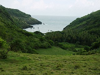
Dauphin was a Quarter on the Caribbean island nation of Saint Lucia. The district was merged with Gros-Islet in 2014. It contains a village of the same name, located at 14°02′N60°54′W. It was home to Amerindians, the Island Caribs, who settled there. To this day, there are ruins which serve as a reminder of people who lived there long before Christopher Columbus crossed the Atlantic from Europe.

Micoud Quarter District in St. Lucia

Micoud District is one of 10 districts of the Caribbean island nation of Saint Lucia The seat of this district is the town of Micoud inside this district. According to the 2002 census, the population of the district was 16,143 people. The final 2010 Census recorded a population of 16,284 in Micoud District. A former quarter, Praslin Quarter, was merged into Micoud Quarter. It was not enumerated separately in the 2010 Census. The 2001 Census shows Praslin as part of Micoud District.

Laborie Quarter District in St. Lucia

Laborie District is one of 10 districts of the Caribbean island nation of Saint Lucia. According to the 2002 census, the population of the Quarter was 7,414 people. The village of Laborie is located about 27 km (17 mi) south of Castries, the nation's capital.

Praslin Quarter Former quarter or district of Saint Lucia

Praslin Quarter was a former quarter on the island nation of Saint Lucia. Since at least 2001, it has been a second-order subdivision of the Micoud District. The 2001 and 2010 Census show Praslin as part of the Micoud District. The population of Praslin is 341.

Bank of Saint Lucia is a subsidiary of Eastern Caribbean Financial Holding Company. It was formed in July 2001 as a result of the merger between National Commercial Bank and the Saint Lucia Development Bank.

The SLFA First Division is the top division of the Saint Lucia Football Association.

The Saint Lucia FA Cup is the top knockout tournament of the Saint Lucia football.

Tourism in Saint Lucia Saint Lucia Tourism

Saint Lucia, an island nation in the Caribbean islands, has a relatively large and lucrative tourism industry. Due to the relatively small land area of the country, most of the governmental promotion is performed by the state-operated Saint Lucia Tourism Authority, led by Executive Chairperson Agnes.

Soufrière, Saint Lucia Town in Soufrière Quarter, Saint Lucia

Soufrière is a town on the West Coast of Saint Lucia, in the eastern Caribbean Sea. The town and the surrounding district has a population of 7,935. It was colonized by the French and was the original capital of the island.

The 2019 SLFA Island Cup was an association football cup competition for the island of Saint Lucia. The tournament began on 2 July 2019 and concluded on 21 December 2019.

References

  1. 1 2 3 4 5 "Map of each district". The Central Statistical Office of Saint Lucia. Retrieved August 12, 2021.
  2. Law, Gwillim (2015). "Districts of Saint Lucia". Statoids. Retrieved August 10, 2021.
  3. 1 2 3 4 "2001 Census" (PDF). Government of Saint Lucia. Retrieved August 11, 2021.
  4. 1 2 3 4 5 6 7 "Saint Lucia 2010 Census". Government of Saint Lucia. Retrieved August 9, 2021.
  5. "About Soufriere". Soufriere Foundation. Retrieved August 24, 2021.
  6. Breen, Henry H (1844). St Lucia Historical Statistical and Descriptive. London.
  7. The 2010 Census breaks the population of Castries into city (1,831), suburbs (10,373), and rural (67,478) for persons and the households of Castries into city (751), suburbs (3,648), and rural (23,296) for households.
  8. "Saint Lucia 2010 Population and Housing Census, Preliminary Report" (PDF). United Nations. April 1, 2011. Retrieved August 10, 2021.
  9. "House of Assembly". Government of Saint Lucia. Retrieved August 10, 2021.
  10. "Report of the Constituency Boundaries Commission for Saint Lucia" (PDF). 2014. Retrieved August 11, 2021.
  11. 1 2 The figures for Laborie & Choiseul are inaccurate as the section of the Choiseul constituency which falls within the Quarter of Laborie (Piaye, Londonderry, Saltibus, etc) was incorrectly included to the list for the Laborie constituency.

Additional bibliographic references: