Saint Lucia is one of many small land masses composing the insular group known as the Windward Islands. Unlike large limestone areas such as Florida, Cuba, and the Yucatan Peninsula, or the Bahamas, which is a small island group composed of coral and sand, St. Lucia is a typical Windward Island formation of volcanic rock that came into existence long after much of the region had already been formed.
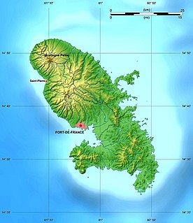
The French Overseas Department of Martinique is a Caribbean island belonging to the Lesser Antilles group in the Caribbean Sea, southeast of Cuba and north of Trinidad and Tobago. It is part of the French West Indies. It lies near the Tropic of Cancer between 14° 26' and 14°53' latitude north and 63° 9' and 63° 34' longitude west. At most some 50 miles long and 22 miles wide, Martinique covers an area of 425 square miles. Its coastline is so indented that no part of the island is more than seven miles from the sea.

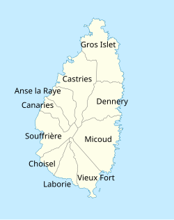
Gros Islet District, one of 10 first order subdivision of the Caribbean island nation of Saint Lucia which includes the island's northernmost point, Cap Point and the notable Cap Estate, where the renowned St. Lucia Golf and Country Club is located. Whilst the town of Gros Islet is an important administrative centre, Rodney Bay is the main financial center of the district.

Dennery District is one of 10 districts of the Caribbean island nation of Saint Lucia. The seat of Dennery District is the Dennery Village. The main economic activities are fishing, and the cultivation of lima beans, bananas, and other tropical fruit. The population of the quarter was estimated at 12,876 in 2002 and fell to 12,767 in 2010.
Anse la Raye District is one of 10 districts of the island nation of St. Lucia in the Caribbean Sea. The name Anse la Raye is French for cover/bay of the rays, since there are a large number of skate fish or rays in the bay. In 2005/2010, the population of the district was 6,382/6,060 people, and they are mainly fishers and agricultural workers. The main town in the area takes the same name as the district and is located down the western coast from Castries, the capital of the country.

The Pitons are two mountainous volcanic plugs, volcanic spires, located in Saint Lucia. Gros Piton is 798.25 m (2,618.9 ft) high, and Petit Piton is 743 m (2,438 ft) high; they are linked by the Piton Mitan ridge. The Pitons are a World Heritage Site, 2,909 ha in size, and located near the town of Soufrière.

Mount Gimie is the tallest mountain on the island of Saint Lucia. It is located in the Canries District on the west side of Saint Lucia. The mountain's peak reaches 950 m (3,120 ft). It is covered by lush tropical rainforest and was formed as the result of intense volcanic activity 200,000 to 300,000 years ago. Mount Gimie is still volcanic and so are many other of the Pitons.
Choiseul District is one of the 10 districts of the Caribbean island nation of Saint Lucia. Located on the southwestern side of the island, the district is home to 6,130 people, according to the 2019 census. The seat of Choiseul District is the town of Choiseul.
Micoud District is one of 10 districts of the Caribbean island nation of Saint Lucia The seat of this district is the town of Micoud inside this district. According to the 2002 census, the population of the district was 16,143 people. The final 2010 Census recorded a population of 16,284 in Micoud District. A former quarter, Praslin Quarter, was merged into Micoud Quarter. It was not enumerated separately in the 2010 Census. The 2001 Census shows Praslin as part of Micoud District.

Saint Lucia, an island nation in the Caribbean islands, has a relatively large and lucrative tourism industry. Due to the relatively small land area of the country, most of the governmental promotion is performed by the state-operated Saint Lucia Tourism Authority, led by Executive Chairperson Agnes.

The Roseau Valley is a second-order subdivision in the island nation of St. Lucia. It is home to the island's largest banana plantation. The 2010 population of the Roseau Valley was 227.

Canaries is a populated place located on the West Coast of Saint Lucia in the Canaries Quarter. It is a small fishing village and it is nestled along the West Coast road, between the towns of Anse La Raye and Soufriere, and there are scenic views from both the Northern and Southern approaches.

Monchy is a town and second-order administrative division of Gros Islet District in the island nation of Saint Lucia. The town is located near the northern end of the island about 4 kilometres (2.5 mi) from Gros Islet, and about 7.9 kilometres (4.9 mi) from the capital, Castries.

Anse Mamin is bay on the coast with a small black sand beach in Soufrière District, Saint Lucia. It is located near Anse Chastanet and the two beaches are linked by a rocky path below the cliffs. Anse Mamin offers 12 kilometres (7.5 mi) of wooded trails.
Ravine Poisson is a second-order subdivision of Saint Lucia with a population of 560 in Castries District of Saint Lucia. Ravine Poisson is also the name of a village in the Ravine Poisson subdivision. The is also a stream with the name Ravine Poisson River.

The Mahaut River is a river in the Laborie Quarter of Saint Lucia. The mouth is at the Caribbean Sea.