Saint Lucia is one of many small land masses composing the insular group known as the Windward Islands. Unlike large limestone areas such as Florida, Cuba, and the Yucatan Peninsula, or the Bahamas, which is a small island group composed of coral and sand, St. Lucia is a typical Windward Island formation of volcanic rock that came into existence long after much of the region had already been formed.

Gros Islet District, one of 10 first order subdivision of the Caribbean island nation of Saint Lucia which includes the island's northernmost point, Cap Point and the notable Cap Estate, where the renowned St. Lucia Golf and Country Club is located. Whilst the town of Gros Islet is an important administrative centre, Rodney Bay is the main financial center of the district.

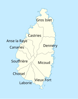
Dennery District is one of 10 districts of the Caribbean island nation of Saint Lucia. The seat of Dennery District is the Dennery Village. The main economic activities are fishing, and the cultivation of lima beans, bananas, and other tropical fruit. The population of the quarter was estimated at 12,876 in 2002 and fell to 12,767 in 2010.
Anse la Raye District is one of 10 districts of the island nation of St. Lucia in the Caribbean Sea. The name Anse la Raye is French for cover/bay of the rays, since there are a large number of skate fish or rays in the bay. In 2005/2010, the population of the district was 6,382/6,060 people, and they are mainly fishers and agricultural workers. The main town in the area takes the same name as the district and is located down the western coast from Castries, the capital of the country.
The island nation of Saint Lucia is divided into 10 districts. The name Quarters or Quartiers originally came from the French period in Saint Lucia. The 2001 and 2010 Census of Saint Lucia refers to the first level administrative divisions as districts. The FIPS and ISO standards regularly called these divisions quarters or quartiers in French. The former district of Dauphin Quarter was merged into Gros Islet District and the former district of Praslin Quarter was merged into Micoud District.
Choiseul District is one of the 10 districts of the Caribbean island nation of Saint Lucia. Located on the southwestern side of the island, the district is home to 6,130 people, according to the 2019 census. The seat of Choiseul District is the town of Choiseul.

Praslin Quarter was a former quarter on the island nation of Saint Lucia. Since at least 2001, it has been a second-order subdivision of the Micoud District. The 2001 and 2010 Census show Praslin as part of the Micoud District. The population of Praslin is 341.
There are several lakes named Mud Lake within the Canadian province of Alberta.

The Gwa'Sala-Nakwaxda'xw Nations are a union of two Kwakwaka'wakw peoples in a band government based on northern Vancouver Island in British Columbia, Canada, whose main reserve community is near the town of Port Hardy in the Queen Charlotte Strait region of the Central Coast region of British Columbia, Canada. The band government is a member of the Kwakiutl District Council and, for treaty negotiation purposes, the Winalagalis Treaty Group which includes three other members of the Kwakiutl District Council.
The Esk'etemc First Nation, also known as the Alkali Lake Indian Band, is a First Nations government of the Secwepemc (Shuswap) people, located at Alkali Lake in the Cariboo region of the Central Interior of the Canadian province of British Columbia. It was created when the government of the then-Colony of British Columbia established an Indian Reserve system in the 1860s. It is one of three Secwepemc bands that is not a member of either the Shuswap Nation Tribal Council or the Northern Shuswap Tribal Council.

Babonneau is one of the regions of the Caribbean island nation of Saint Lucia. Babonneau is located in the north of the island in the Castries Quarter. There are extensive rain forests in the region, which is an important source of fresh water for Saint Lucia. Babonneau is also an electoral constituency of Saint Lucia represented in the House of Assembly of Saint Lucia, which extends into Gros Islet District.

Saint Lucia, an island nation in the Caribbean islands, has a relatively large and lucrative tourism industry. Due to the relatively small land area of the country, most of the governmental promotion is performed by the state-operated Saint Lucia Tourism Authority, led by Executive Chairperson Agnes.
The Mabouya Valley in eastern St. Lucia in Dennery District contains two rivers, the Grande Rivière du Mabouya and the Dernière Rivière. The forested hillsides have, in places, been cleared for farming and the valley receives annual rainfall of 3000 mm (118 inches) at its head in Barre de l'Isle and 2000 mm (79 inches) at La Caye.

The Roseau Valley is a second-order subdivision in the island nation of St. Lucia. It is home to the island's largest banana plantation. The 2010 population of the Roseau Valley was 227.
Mon Repos is a village on the island nation of Saint Lucia. It is located on the Atlantic Ocean coast of Saint Lucia, near Praslin, Micoud District. It contains many communities including Lumbard, Mamiku, La Pointe, Patience, Collie Town, St. Marie, Vietnam, Malgretoute, Ryon, Piton.
Ti Rocher is a town in the Micoud District of the island nation of Saint Lucia. It is also a 2nd level division in Micoud District.

Canaries District is one of 10 districts of the island nation of St. Lucia in the Caribbean Sea. In 2010, the population of the region was 2,009 people, and they are mainly fishers and agricultural workers. The main town in the area takes the same name as the district and is located down the western coast from Castries, the capital of the country. It is the smallest quarter of Saint Lucia, both by population and area.

The Tsay Keh Dene First Nation is one of the Sekani bands of the Northern Interior of British Columbia. Tsay Keh Dene means "People of the Mountain". While they have an office in the City of Prince George, their territories, settlements, and Indian Reserves are all to the north, in the area of Williston Lake.