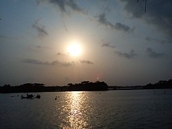
Baleshwari River

Last updated
Baleshwari River
Baleshwar river.jpg
Baleshwar River
Baleshwari River
Location
Country Bangladesh
Region Barisal Division
Districts Bagerhat and Barguna
Physical characteristics
Source Kaliganga River
  coordinates 22°44′03″N89°59′50″E / 22.734102°N 89.997233°E / 22.734102; 89.997233
Mouth Haringhata River (to the Bay of Bengal)
  coordinates
22°29′25″N89°58′48″E / 22.490253°N 89.980103°E / 22.490253; 89.980103
Length146 km (91 mi)

The Baleshwari River is located in Bangladesh, forming part of the eastern border of Bagerhat District and the western border of Barguna District. [1] It borders on the east the largest mangrove forest in the world, in the Ganges-Brahmaputra delta, the Bangladesh part of which is set aside as the Sundarbans Reserve Forest. The 146 kilometers long Baleshwar flows south into the Haringhata River, which empties into the Bay of Bengal.

See also

Related Research Articles

<span class="mw-page-title-main">Khulna Division</span> Division of Bangladesh

The Khulna Division is the second largest of the eight divisions of Bangladesh. It has an area of 22,285 km2 (8,604 sq mi) and a population of 17,416,645 at the 2022 Bangladesh census. Its headquarters and largest city is Khulna city in Khulna District.

<span class="mw-page-title-main">Khulna</span> Metropolis in Khulna Division, Bangladesh

Khulna is the third-largest city in Bangladesh, after Dhaka and Chittagong. It is the administrative center of the Khulna District and the Khulna Division. Khulna's economy is the third-largest in Bangladesh, contributing $53 billion in gross regional domestic product and $95 billion in purchasing power parity (PPP) in 2020. In the 2024 census, the city corporation area had a population of 884,445.

<span class="mw-page-title-main">Sundarbans National Park</span> National park and nature reserve in West Bengal, India

The Sundarbans National Park is a national park in West Bengal, India, and core part of tiger reserve and biosphere reserve. It is part of the Sundarbans on the Ganges Delta and adjacent to the Sundarban Reserve Forest in Bangladesh. It is located to south-west of Bangladesh. The delta is densely covered by mangrove forests, and is one of the largest reserves for the Bengal tiger. It is also home to a variety of bird, reptile and invertebrate species, including the salt-water crocodile. The present Sundarban National Park was declared as the core area of Sundarban Tiger Reserve in 1973 and a wildlife sanctuary in 1977. On 4 May 1984 it was declared a national park. It is a UNESCO World Heritage Site inscribed in 1987, and it has been designated as a Ramsar site since 2019. It is considered as a World Network of Biosphere Reserve from 1989.

<span class="mw-page-title-main">Sundarbans</span> Mangrove forest in the Bay of Bengal

Sundarbans is a mangrove area in the delta formed by the confluence of the Ganges, Brahmaputra and Meghna Rivers in the Bay of Bengal. Spread across parts of India and Bangladesh, this forest is the largest Mangrove forest in the world. It spans the area from the Baleswar River in Bangladesh's division of Khulna to the Hooghly River in India's state of West Bengal. It comprises closed and open mangrove forests, land used for agricultural purpose, mudflats and barren land, and is intersected by multiple tidal streams and channels. Sundarbans is home to the world's largest area of mangrove forests. Four protected areas in the Sundarbans are enlisted as UNESCO World Heritage Sites, viz. Sundarbans West (Bangladesh), Sundarbans South (Bangladesh), Sundarbans East (Bangladesh) and Sundarbans National Park (India).

<span class="mw-page-title-main">Barguna District</span> District of Bangladesh in Barisal Division

Barguna is a district in the division of Barisal, in southern Bangladesh. Barguna subdivision was established in 1969 and promoted to a district on 28 February 1984.

<span class="mw-page-title-main">Pirojpur District</span> District in Barisal, Bangladesh

Pirojpur is a district (zilla) in south-western Bangladesh. It is a part of Barisal Division.

<span class="mw-page-title-main">Bagerhat District</span> District of Bangladesh in Khulna Division

Bagerhat District is a district in south-western Bangladesh. It is a part of the Khulna Division.

<span class="mw-page-title-main">Mosque City of Bagerhat</span> UNESCO World Heritage Site in Bagerhat District, Bangladesh

The Mosque City of Bagerhat is a UNESCO World Heritage Site in Bagerhat District, Bangladesh. It contains 360 mosques, public buildings, mausoleums, bridges, roads, water tanks and other public buildings constructed from baked brick. The mosques were built during the Bengal Sultanate in the 15th century, of which the Sixty Dome Mosque is the largest. Other mosques include the Singar Mosque, the Nine Dome Mosque, the Tomb of Khan Jahan, the Bibi Begni Mosque and the Ronvijoypur Mosque. The mosques were built during the governorship of Ulugh Khan Jahan, a Turkic military officer appointed as governor in the Sundarbans by Sultan Mahmud Shah of Bengal.

<span class="mw-page-title-main">Khulna District</span> District of Bangladesh in Khulna

The Khulna District is a district of Bangladesh. It is located in the Khulna Division, bordered on the north by Jessore District and Narail District, on the south by the Bay of Bengal, on the east by the Bagerhat District, and on the west by the Satkhira District. It was the first sub-division of United Bengal Province established in 1842.On 1 June 1882, by notification of the official gazette published from Kolkata, Khulna and Bagerhat sub-division of Jessore district and Satkhira sub-division of 24 Pargana district together formed the new district of Khulna.

<span class="mw-page-title-main">Sixty Dome Mosque</span> Mosque in Bagerhat, Bangladesh

The Sixty Dome Mosque, is a mosque in Bagerhat, Bangladesh. It is a part of the Mosque City of Bagerhat, a UNESCO World Heritage Site. It is the largest mosque in Bangladesh from the sultanate period (1352–1576). It was built during the Bengal Sultanate by Khan Jahan Ali, the governor of the Sundarbans. It has been described as "one of the most impressive Muslim monuments in the whole of South Asia."

<span class="mw-page-title-main">Bagerhat Sadar Upazila</span> Upazila in Khulna, Bangladesh

Bagerhat Sadar is an upazila of Bagerhat District in the Division of Khulna, Bangladesh. The municipality was established in 1958. It consists of 9 wards and 31 mahallas.

<span class="mw-page-title-main">Fakirhat Upazila</span> Upazila in Khulna, Bangladesh

Fakirhat is a Upazila (sub-district) of Bagerhat District in the Division of Khulna, Bangladesh. The medieval Sixty Dome Mosque and the Khan Jahan Ali Mazar are situated here.

<span class="mw-page-title-main">Kachua Upazila, Bagerhat</span> Upazila in Khulna, Bangladesh

Kachua is an upazila of Bagerhat District in the Division of Khulna, Bangladesh. Kachua Thana was turned into an upazila in 1983. Distance from Kachua to the district town is 16 km.

<span class="mw-page-title-main">Mongla Upazila</span> Upazila in Khulna, Bangladesh

Mongla is an upazila of Bagerhat District in the Division of Khulna, Bangladesh. Its headquarters are the town of Mongla.

<span class="mw-page-title-main">Morrelganj Upazila</span> Upazila in Khulna, Bangladesh

Morrelganj is an upazila of Bagerhat District in the Division of Khulna, Bangladesh. Morrelganj thana was established in 1909 and became an upazila in 1985.

<span class="mw-page-title-main">Tourism in Bangladesh</span>

Tourism in Bangladesh includes tourism to World Heritage Sites, historical monuments, resorts, beaches, picnic spots, forests, tribal people, and wildlife of various species. Activities for tourists include angling, water skiing, river cruising, hiking, rowing, yachting, beachgoing and sea bathing.

<span class="mw-page-title-main">Rampal Power Station</span> Coal-fired power station in Bangladesh

The Rampal Power Station is a 1320 megawatt coal-fired power station currently under construction at Rampal Upazila of Bagerhat District in Khulna, Bangladesh. The power plant, being constructed over 1834 acres of land, is situated 14 kilometres north of the world's largest mangrove forest Sundarbans, which is a UNESCO World Heritage Site. It will be the country's largest power plant.

The Haringhata River is located in Bangladesh. It is one of the large coastal rivers of the Ganges-Padma system south of the confluence of the Bhola and the Baleshwar, and sets part of the boundary between Bagerhat District and Barguna District before emptying into the Bay of Bengal. The Haringhata flows between Sarankhola Upazila in Bagerhat district, and Patharghata Upazila of Barguna district.

<span class="mw-page-title-main">Masjidkur Mosque</span> Archaeological site of Bangladesh

Masjidkur Mosque is one of the archaeological sights of Bangladesh, located in Koyra Upazila of Khulna District. The Kapotaksha River is beside the mosque and very close to the Sundarbans.

Dudhmukhi Wildlife Sanctuary is a wildlife sanctuary located near Sarankhola in Bagerhat District of Bangladesh. The area of the sanctuary is 170 ha. It was officially declared as a wildlife sanctuary by the government of Bangladesh on 29 January 2012.

References

  1. Kamal, HM Khaled (2012). "Bagerhat District". In Islam, Sirajul; Jamal, Ahmed A. (eds.). Banglapedia: National Encyclopedia of Bangladesh (Second ed.). Asiatic Society of Bangladesh.