
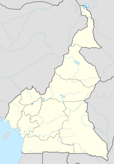
Cameroon, officially the Republic of Cameroon, is a country in west-central Africa. It is bordered by Nigeria to the west and north; Chad to the northeast; the Central African Republic to the east; and Equatorial Guinea, Gabon and the Republic of the Congo to the south. Its coastline lies on the Bight of Biafra, part of the Gulf of Guinea and the Atlantic Ocean. The country is sometimes identified as West African and other times as Central African, due to its strategic position at the crossroads between West and Central Africa. Its nearly 25 million people speak 250 native languages.

The demographic profile of Cameroon is complex for a country of its population. Cameroon comprises an estimated 250 distinct ethnic groups, which may be formed into five large regional-cultural divisions:
An arrondissement is any of various administrative divisions of France, Belgium, Haiti, certain other Francophone countries, as well as the Netherlands.

The Northwest Region, or North-West Region is one of ten regions in Cameroon. Its regional capitol is Bamenda. The Northwest Region is part of the Southern Cameroons, found in the western highlands of Cameroon. It is bordered to the southwest by the Southwest Region, to the south by the West Region, to the east by the Adamawa Region, and to the north by Nigeria. Various Ambazonian nationalist and separatist factions regard the region as being distinct as a polity from Cameroon.

Ambazonia, officially the Federal Republic of Ambazonia, also referred to as Amba Land, is a self-declared state in West Africa constituting the Northwest Region and Southwest Region of Cameroon, part of the country historically known as the Southern Cameroons. No country has formally recognized Ambazonia's independence, and it is currently the site of an armed conflict between Ambazonian separatists and the Cameroonian military known as the Anglophone Crisis. Ambazonia is located in the west of Cameroon and southeast of Nigeria on the Gulf of Guinea.
The Ekang are a group of closely related Bantu ethnic groups located in rain forest regions of Cameroon, Republic of the Congo, Equatorial Guinea, Gabon, and São Tomé and Príncipe. Though they separate themselves into several individual clans, they all share a common origin, history and culture.

Mbalmayo is a city in Cameroon's Centre Province. The town had 60,091 inhabitants in 2012. It is the capital of the Nyong-et-So'o Department. It is located at the banks of the Nyong river between Ebolowa and Yaoundé. It is an agricultural centre and has an important function as a centre of education. Site of the Mbalmayo National Forestry School.

The Musgum or Mulwi are a Chadic ethnic group in Cameroon and Chad. They speak Musgu, a Chadic language, which had 61,500 speakers in Cameroon in 1982 and 24,408 speakers in Chad in 1993. The Musgum call themselves Mulwi.
Moloundou is an arrondissement (district) in the Boumba-et-Ngoko Division of southeastern Cameroon's East Province. Mouloundou is close to Boumba Bek and Nki National Parks on the Dja River. It has a mayor and several decentralised administrative services.
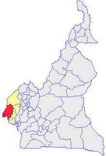
Ndian is a department of Southwest Region in Cameroon. It is located in the humid tropical rainforest zone about 650 km (400 mi) southeast of Yaoundé, the capital.
The Widikum people are an ethnic group of Cameroon and are one of the largest ethnic groups of the North-West Region of Cameroon.
Ndu is a town and commune in Donga-Mantung, a division in the Northwest Region of Cameroon. It lies at the northeast edge of the Bamenda Grassfields, on the eastern arc of the Ring Road. It is the highest elevation town in Cameroon.
Nyong (Daganyonga), also known as Mubako and Bali-Kumbat, is a Leko language spoken in two well-separated enclaves in Cameroon and Nigeria. Cameroonian speakers consider themselves to be ethnically Chamba.
Limbum is a Grassfields language of Cameroon, with a small number of speakers in Nigeria. It is used as a trade language by some, but is primarily the mother tongue of the Wimbum people, who live in Donga-Mantung division of the Northwest Region, at the top of the Ring Road.
Abortion in Cameroon is only legal if the abortion will save the woman's life, the pregnancy gravely endangers the woman's physical or mental health, or the pregnancy is a result of rape.

Babungo is one of the four villages of Babessi Sub Division, Ngoketunjia Division of the North West Region Cameroon. It is situated on the Ring Road from Bamenda about ten kilometers from Bamunka on the high plain of Ndop which is fertile and rich in water, intensely cultivated and surrounded by a ring of hills covered with pastures, making it an ideal grazing land.
Babessi is one of the four villages that make up the Babessi Sub-Division, and the Babessi Sub-Division is one of three sub-divisions of Ngoketunjia Division of the North West Region of Cameroon with a population of 26,802.

Bamessing village is one of four villages that make up Ndop central Central Sub Division, and one of thirteen villages of Ngoketunjia division of the North West region of Cameroon. Bamessing is located along the ring road from Bamenda, some 38 km from the town of Bamenda, on the Bamenda-Nkambe stretch of the ring road, just before Bamunka.
Bamali village is one of the four villages that make up Ndop Central sub division and one of the thirteen villages of Ngoketunjia division of the North West region of Cameroon. Bamali village is located partly along the ring road from Bamenda some 40 km away from Bamenda town on the Bamenda-Nkambe stretch of the ring road just before reaching Bamunka.
Bangolan village is one of the four villages that make up Babessi sub division and one of the thirteen villages of Ngoketunjia division of the North West region of Cameroon. Since 2016, Bangolan village have been flooded with armed forces following the dethronement of their Fon and villagers have since been deserting the village.
