
Greenwich Village often referred to by locals as simply "the Village", is a neighborhood on the west side of Lower Manhattan, New York City. In the 20th century, Greenwich Village was known as an artists' haven, the Bohemian capital, the cradle of the modern LGBT movement, and the East Coast birthplace of both the Beat and '60s counterculture movements. Groenwijck, one of the Dutch names for the village, was Anglicized to Greenwich. Greenwich Village contains Washington Square Park, as well as two of New York's private colleges, New York University (NYU) and the New School.

A municipality is usually a single administrative division having corporate status and powers of self-government or jurisdiction as granted by national and regional laws to which it is subordinate. It is to be distinguished (usually) from the county, which may encompass rural territory or numerous small communities such as towns, villages and hamlets.

A village is a clustered human settlement or community, larger than a hamlet but smaller than a town, with a population ranging from a few hundred to a few thousand. Though villages are often located in rural areas, the term urban village is also applied to certain urban neighborhoods. Villages are normally permanent, with fixed dwellings; however, transient villages can occur. Further, the dwellings of a village are fairly close to one another, not scattered broadly over the landscape, as a dispersed settlement.
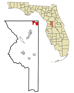
The Villages is a census-designated place (CDP) in Sumter County, Florida, United States. It shares its name with a broader master-planned age-restricted community that spreads into portions of Lake and Marion counties. The overall development lies in central Florida, approximately 20 miles (32 km) south of Ocala and approximately 45 miles (72 km) northwest of Orlando.

Northbrook is a suburb of Chicago, located at the northern edge of Cook County, Illinois, United States.
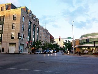
Oak Park is a village adjacent to the West Side of Chicago, Illinois. It is the 29th largest municipality in Illinois as measured by population in the 2010 U.S. census. As of the 2010 United States Census the village had a population of 51,878.

Streamwood is a village in Cook County, Illinois, United States. The population was 39,858 at the 2010 census. It is a northwest suburb of Chicago, and is a part of the Chicago metropolitan area.

The administrative divisions of New York are the various units of government that provide local government services in the state of New York.

According to the Moldovan law on territorial administrative organisation, Moldova is divided administratively into the following administrative territorial units: districts, cities/towns and villages. The administrative territorial organization of Moldova is made on 2 levels:
- villages (communes), sectors and cities/towns (municipalities) constitute the first level,
- districts, Chișinău municipality, Bălți municipality and Bender municipality constitute the second level.
The administrative divisions of India are subnational administrative units of India; they compose a nested hierarchy of country subdivisions. Indian states and territories frequently use different local titles for the same level of subdivision.
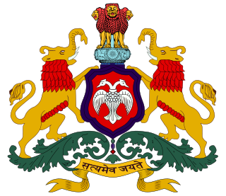
The Government of Karnataka is a democratically elected body with the governor as the constitutional head. The governor who is appointed for five years appoints the chief minister and on the advice of the chief minister appoints his council of ministers. Even though the governor remains the ceremonial head of the state, the day-to-day running of the government is taken care of by the chief minister and his council of ministers in whom a great amount of legislative powers are vested.

Ludhiana District is one of the 22 districts in the state of Punjab in northwest India. Ludhiana city, the district headquarters, is the hub of industry in Punjab. The main industries are bicycle parts and hosiery. Ludhiana is the biggest city of the state. It has eight tehsils, seven sub-tehsils and twelve development blocks. As of 2018, Total Population of Punjab is estimated to be 30,452,879.

Muban is the lowest administrative sub-division of Thailand. Usually translated as village and sometimes as hamlet, they are a subdivision of a tambon. As of 2008, there were 74,944 administrative muban in Thailand. As of the 1990 census, the average village consisted of 144 households or 746 persons.
The administrative divisions of Wisconsin include counties, cities, villages and towns. In Wisconsin, all of these are units of general-purpose local government. There are also a number of special-purpose districts formed to handle regional concerns, such as school districts.
A bakhsh is a type of administrative division of Iran. While sometimes translated as county, it should be more accurately translated as district, similar to a township in the United States or a district of England.
In the United States, the meaning of "village" varies by geographic area and legal jurisdiction. In many areas, "village" is a term, sometimes informal, for a type of administrative division at the local government level. Since the Tenth Amendment to the United States Constitution prohibits the federal government from legislating on local government, the states are free to have political subdivisions called "villages" or not to and to define the word in many ways. Typically, a village is a type of municipality, although it can also be a special district or an unincorporated area. It may or may not be recognized for governmental purposes.
A tehsil is an administrative division in some countries of South Asia. It is an area of land with a city or town that serves as its administrative centre, with possible additional towns, and usually a number of villages. The terms in India have replaced earlier geographical terms, such as pargana, pergunnah and thannah, used under Delhi Sultanate and the British Raj.
Karambal is a village in Belgaum district in Karnataka, India. Karambal village is located in Khanapur Tehsil of Belgaum district in Karnataka, India. It is situated 3km away from sub-district headquarter Khanapur and 28km away from district headquarter Belgaum. As per 2009 stats, Karmbla is the gram panchayat of Karambal village. The total geographical area of village is 387.3 hectares. Karambal has a total population of 1,400 peoples. There are about 294 houses in Karambal village. Khanapur is nearest town to Karambal which is approximately 3km away.

Bijoynagar is a town in the Kamrup district. It is on the south bank of the river Brahmaputra.
Sutargaon is a village in Kamrup rural district, situated in north bank of river Brahmaputra, surrounded by Baihata, Goreswar.

