This is a list of the extreme points of Ireland – the points that are farthest north, south, east or west in Ireland. It includes the Republic of Ireland and Northern Ireland.

The River Swale in Yorkshire, England, is a major tributary of the River Ure, which becomes the River Ouse, that empties into the North Sea via the Humber Estuary. The river gives its name to Swaledale, the valley through which it flows.

The River Bann is one of the longest rivers in Northern Ireland, its length, Upper and Lower Bann combined, being 129 km (80 mi). However, the total length of the River Bann, including its path through the 30 km (19 mi) long Lough Neagh is 159 km (99 mi). Another length of the River Bann given is 90 mi. The river winds its way from the southeast corner of Northern Ireland to the northwest coast, pausing in the middle to widen into the enormous Lough Neagh. The River Bann catchment has an area of 5,775 km2. The River Bann has a mean discharge rate of 92 m3/s. According to C. Michael Hogan, the Bann River Valley is a settlement area for some of the first human arrivals in Ireland after the most recent glacial retreat. The river has played an important part in the industrialisation in Northern Ireland, especially in the linen industry. Today salmon and eel fisheries are the most important economic features of the river. The river is often used as a dividing line between the eastern and western areas of Northern Ireland, often labelled the "Bann divide". Towns, councils and businesses "west of the Bann" are often seen as having less investment and government spending than those to the east. It is also seen as a religious, economic and political divide, with Catholics and Irish nationalists being in the majority to the west, and Ulster Protestants and unionists in the majority to the east; and with the financial and industrial capital of Greater Belfast to the east with the west of the Bann being more agricultural and rural.
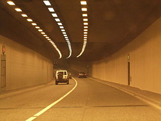
The Jack Lynch Tunnel is an immersed tube tunnel and an integral part of the N40 road network in Cork, Ireland. It is named after former Taoiseach, Jack Lynch, a native of Cork.

The N26 road is a national primary road in northeast County Mayo in Ireland connecting the N5 road at Swinford with the N58 at Foxford and then on to the N59 road at Ballina. The road also meets six regional roads along its route, and it is 29.79 kilometres (18.51 mi) long.

Dowra is a village and townland in northwest County Cavan, Ireland. Located in a valley on Lough Allen, it is the first village on, and marks the most uppermost navigable point of, the River Shannon. On one side of its bridge is County Cavan; on the other is County Leitrim. The nucleus of the village is situated on the Cavan side. It is located on the junction of the R200 and R207 regional roads.
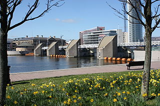
The Lagan Weir, in Belfast, Northern Ireland, crosses the River Lagan between the Queen Elizabeth Bridge and the M3 cross-harbour bridge. Prior to the building of the weir, the river would be subject to tidal fluctuations, and low tide would expose mudflats, which were unsightly and emitted a strong odour, particularly in the summer months. Opened in 1994, the weir was seen by the Laganside Corporation as a catalyst for its redevelopment projects and was judged to be the "centrepiece" of that effort. The weir also incorporates a footbridge.

The River Blackwater or Ulster Blackwater is a river mainly in County Armagh and County Tyrone, Northern Ireland. It also forms part of the border between the United Kingdom and the Republic of Ireland, flowing between Counties Tyrone and Monaghan, intersecting into County Monaghan briefly. Its source is to the north of Fivemiletown, County Tyrone. The river divides County Armagh from County Tyrone and also divides County Tyrone from County Monaghan.
Douglas Bridge is a small village near Strabane in County Tyrone, Northern Ireland. In the 2011 Census it had a population of 124. It lies within the Derry City and Strabane area.

The Strabane Canal is a short (6.5 km) canal in County Tyrone, Northern Ireland. It connected the market town of Strabane to the navigable River Foyle and from there to the port of Foyle Port on the north coast of Ireland. The canal opened in 1796 and closed in 1962.

Shanmaghery or Shanmaghry is a small hamlet and townland in County Tyrone, Northern Ireland, situated three miles from Pomeroy and three miles from Galbally. It is situated in the barony of Dungannon Middle and the civil parish of Pomeroy and covers an area of 426 acres. In 1841 the population of the townland was 193 people and in 1851 it was 161 people. "Paul's Planting" was a notable landmark on top of the hill.

The Oakland Estuary is the strait in the San Francisco Bay Area, California, separating the cities of Oakland and Alameda and the Alameda Island from the East Bay mainland. On its western end, it connects to San Francisco Bay proper, while its eastern end connects to San Leandro Bay.

The River Swilly is a river in County Donegal, Ireland, which flows in an eastern direction through Letterkenny. Letterkenny, the largest town in County Donegal, is built on the river and became the first crossing point on the river in the 17th century.

The R747 road is a regional road in Ireland running north-west/south-east from the M9 near Ballitore in County Kildare to Arklow in County Wicklow, a distance of 66 km (41 mi).

European route E1 is a series of roads in Europe, part of the United Nations International E-road network, running from Larne, Northern Ireland to Seville, Spain. There is a sea crossing between Rosslare Harbour, in Ireland, and Ferrol, but no ferry service. The road also passes through Portugal – past the city of Porto, through the capital, Lisbon, and then south to the Algarve, passing Faro before reaching the Spanish border west of Huelva.

The Castlederg and Victoria Bridge Tramway was a 3 ft narrow gauge railway operating in County Tyrone, Northern Ireland. It opened in 1883 and closed in 1933.
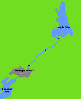
The River Eske is a river in County Donegal, Ireland. It begins at Lough Eske in the southeast of the county before flowing mainly westwards to the town of Donegal and into the Atlantic Ocean via Donegal Bay.
James Dredge (1794–1863) was an English civil engineer, architect and brewer. He was born in Bath and was a brewer by trade for much of his life. He designed over 50 bridges and piers in his later years, such as the Victoria Bridge in Bath in 1836, and the Birnbeck Pier in Weston-super-Mare in 1845.
The Walney Channel separates Walney Island from the British mainland. The northern portion of the channel opens into the Duddon Estuary and is both narrower and shallower. The southern half of the channel is wider and is regularly dredged to allow shipping to access the Port of Barrow. This half opens into Morecambe Bay.

The River Clady is a mid-scale river in County Londonderry, Northern Ireland, a tributary of the Lower Bann. It forms from the confluence of the Grillagh River and Knockoneil River.

