
Galway-Mayo Institute of Technology (GMIT) is a third-level institute of education and is based at five locations in the west of Ireland. GMIT's campuses are located in Galway City, Castlebar, Letterfrack and Mountbellew. GMIT won The Sunday Times Institute of Technology of the Year award in 2004, 2007, 2015 and 2022. GMIT also has a number of specialist research centres and two Innovation Hubs.

Doolin is a coastal village in County Clare, Ireland, on the Atlantic coast. It is southwest of the spa town of Lisdoonvarna. It is a noted centre of traditional Irish music, which is played nightly in its pubs, making it a popular tourist destination. There are numerous nearby archaeological sites, many dating to the Iron Age and earlier. Doonagore Castle and Ballinalacken Castle are also in the area. The area was officially classified as part of the West Clare Gaeltacht prior to the 1950s, and maintains a connection with Irish-speaking areas - including via its maritime connection with the Aran Islands.

Connemara is a region on the Atlantic coast of western County Galway, in the west of Ireland. The area has a strong association with traditional Irish culture and contains much of the Connacht Irish-speaking Gaeltacht, which is a key part of the identity of the region and is the largest Gaeltacht in the country. Historically, Connemara was part of the territory of Iar Connacht. Geographically, it has many mountains, peninsulas, coves, islands and small lakes. Connemara National Park is in the northwest. It is mostly rural and its largest settlement is Clifden.

Ballinakill is a small village in County Laois, Ireland on the R432 regional road between Abbeyleix, Ballyragget and Castlecomer, County Kilkenny. As of the 2016 census, there were 445 people living in Ballinakill.

Inishbofin is a small island off the coast of Connemara, County Galway, Ireland. Inishbofin has around 180 inhabitants and is a tourist destination.

Letterfrack or Letterfrac is a small village in the Connemara area of County Galway, Ireland. It was founded by Quakers in the mid-19th century. The village is south-east of Renvyle peninsula and 15 kilometres north-east of Clifden on Barnaderg Bay and lies at the head of Ballinakill harbour. Letterfrack contains the visitors centre for Connemara National Park.

Spike Island is an island of 103 acres (42 ha) in Cork Harbour, Ireland. Originally the site of a monastic settlement, the island is dominated by an 18th-century bastion fort now named Fort Mitchel.

Kilmore Quay is a fishing village near Kilmore, in County Wexford, Ireland. As of 2016, it has a population of 372. It is a fishing village, but its leisure facilities such as sailing, and sea angling charters are also of economic importance.
The Rock GAA is a Gaelic Athletic Association gaelic football club based just outside the town of Mountmellick in County Laois, Ireland.
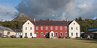
St Joseph's Industrial School was an industrial school for young boys in Letterfrack, County Galway, Ireland. The school was built in 1886/7 after the designs of the architect William Hague, opened in 1887, and run by the Congregation of Christian Brothers.
Peter Tyrrell was an Irish author and former inmate of St Joseph's Industrial School, Letterfrack, an institution run by the Christian Brothers.
Garinish or Garnish Island is an island in Glengarriff Bay, an inlet of Bantry Bay, near the shore of the Beara Peninsula in County Cork, Ireland. It is a popular tourist attraction with walled gardens and a Martello tower.
Letter Hill is a large hill near the coast to the north-west of Letterfrack in County Galway, Ireland. It is 356 m (1,168 ft) high and been listed as a Special Area of Conservation.

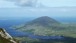
Diamond Hill or Bengooria is an isolated peak overlooking the village of Letterfrack, in the northwest corner of the Twelve Bens in Connemara National Park in County Galway, Ireland. At only 442 metres (1,450 ft), it does not rank as an Arderin, or a Vandeleur-Lynam; however, it has the prominence to rank as a Marilyn. Diamond Hill is It lies just west of Knockbrack and the small massif of Benbrack, and looks into the Polladirk valley, around which several major Bens are located. Despite its moderate size and isolation, Diamond Hill is a popular peak with tourists due to its paths and boarded mountain trail, and relative ease of access, together with well-regarded views of the core Twelve Bens range, and western Connemara.

Tully Cross is a small village located on the Renvyle Peninsula in north-west Connemara, in County Galway, Ireland. It is actually situated in the townland of Gorteenclough. The village lies close to the sea and is on the Wild Atlantic Way coastal route.

Renvyle or Rinvyle is a peninsula and electoral division in North-West Connemara in County Galway, close to the border with County Mayo in Ireland.

