Ballineen and Enniskean | |||||||||||
|---|---|---|---|---|---|---|---|---|---|---|---|
| General information | |||||||||||
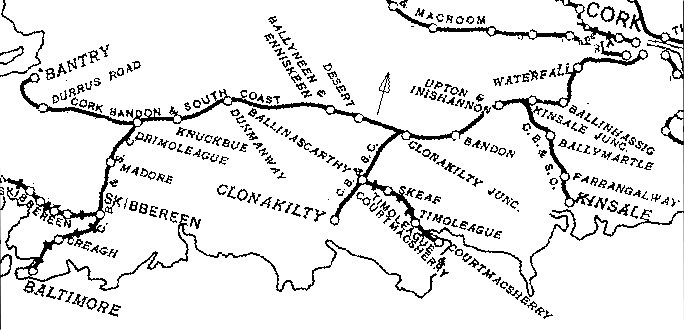
| Location | Ballineen and Enniskean, County Cork Ireland | ||||||||||
| Coordinates | 51°44′08″N8°56′29″W / 51.7355°N 8.9413°W | ||||||||||
| History | |||||||||||
| Opened | 1891 | ||||||||||
| Original company | West Cork Railway | ||||||||||
| Pre-grouping | Cork, Bandon and South Coast Railway | ||||||||||
| Post-grouping | Great Southern Railways | ||||||||||
| Key dates | |||||||||||
| 12 June 1866 | Two stations opened separately | ||||||||||
| 15 May 1891 | Stations merged | ||||||||||
| 15 May 1961 | Station closes | ||||||||||
| Services | |||||||||||
| |||||||||||
| |||||||||||


Ballineen and Enniskean railway station was on the West Cork Railway and served the twin villages of Ballineen and Enniskean in County Cork, Ireland.