
Ochroma pyramidale, commonly known as the balsa tree, is a large, fast-growing tree native to the Americas. It is the sole member of the genus Ochroma. The name balsa comes from the Spanish word for "raft."

Manaus is the capital and largest city of the Brazilian state of Amazonas. It is the seventh-largest city in Brazil, with an estimated 2020 population of 2,219,580 distributed over a land area of about 11,401 km2 (4,402 sq mi). Located at the east center of the state, the city is the center of the Manaus metropolitan area and the largest metropolitan area in the North Region of Brazil by urban landmass. It is situated near the confluence of the Negro and Solimões rivers.
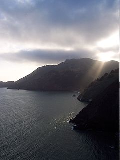
The Marin Headlands is a hilly peninsula at the southernmost end of Marin County, California, United States, located just north of San Francisco across the Golden Gate Bridge, which connects the two counties and peninsulas. The entire area is part of the Golden Gate National Recreation Area. The Headlands are famous for their views of the Bay Area, especially of the Golden Gate Bridge.

Google Earth is a computer program, formerly known as Keyhole EarthViewer, that renders a 3D representation of Earth based primarily on satellite imagery. The program maps the Earth by superimposing satellite images, aerial photography, and GIS data onto a 3D globe, allowing users to see cities and landscapes from various angles. Users can explore the globe by entering addresses and coordinates, or by using a keyboard or mouse. The program can also be downloaded on a smartphone or tablet, using a touch screen or stylus to navigate. Users may use the program to add their own data using Keyhole Markup Language and upload them through various sources, such as forums or blogs. Google Earth is able to show various kinds of images overlaid on the surface of the earth and is also a Web Map Service client. Recently Google has revealed that Google Earth now covers more than 98 percent of the world, and has captured 10 million miles of Street View imagery, a distance that could circle the globe more than 400 times.

Clackmannan, is a small town and civil parish set in the Central Lowlands of Scotland. Situated within the Forth Valley, Clackmannan is 1.8 miles (2.9 km) south-east of Alloa and 3.2 miles (5.1 km) south of Tillicoultry. The town is within the county of Clackmannanshire, of which it was formerly the county town, until Alloa overtook it in size and importance.

The Saemangeum Seawall, located on the southwest coast of the Korean peninsula, is the world's longest man-made dyke, measuring 33 kilometres (21 mi). It runs between two headlands, and separates the Yellow Sea and the former Saemangeum estuary.
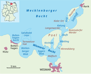
The Bay of Wismar or more commonly Wismar Bay or Wismarbucht is a well sheltered multi-sectioned bay in the southwestern Baltic Sea, in Mecklenburg-Vorpommern, Germany, and is considered the south-central part of the much larger arm of the Baltic known as the Mecklenburg Bay —a long fingerlike gulf oriented to the west-southwest (WSW) from the (central) Baltic proper. Wismar bay is considered one of the finest natural harbors on the Baltic, and served as the destination for much seaborne shipping until circa the 1910s when its minimum depths of 5 meters (16 ft) became too shallow for larger more modern ships. Today, because of the shallow sheltered waters the bay is the subject of much research via underwater archeology
The Roman Catholic Diocese of Balsas is a diocese located in the city of Balsas in the Ecclesiastical province of São Luís do Maranhão in Brazil.
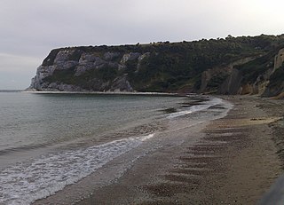
Whitecliff Bay is a sandy bay near Foreland which is the easternmost point of the Isle of Wight, England, about two miles south-west of Bembridge and just to the north of Culver Down. The bay has a shoreline of around three-quarters of a mile (1.2 km) and has a popular sandy shingle beach which is over half a mile long. It is a tourist site with three holiday parks in the vicinity of the bay; it has two cafes though minimal facilities. Access is limited and only possible down two steeply sloping concrete tracks.
Balsa is the tree Ochroma pyramidale or the light-weight wood it produces.
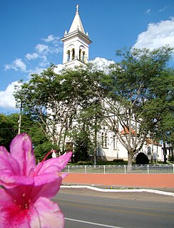
Balsa Nova is a municipality in the state of Paraná in the Southern Region of Brazil. It has a population of 13,092 and covers 348.926 square kilometres (134.721 sq mi). Balsa Nova borders the municipalities of Araucária, Campo Largo, Contenda, Lapa, Palmeira and Porto Amazonas, all in the east of the state of Paraná.
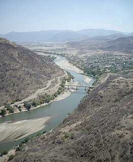
The Balsas River is a major river of south-central Mexico.

Kelsey Head is a coastal Site of Special Scientific Interest (SSSI) and headland in north Cornwall, England, UK, noted for its biological interest. The site contains an Iron Age hill fort.

Ptichy Island is a small island in the Sea of Okhotsk. It lies close to the mainland off the western coast of the Kamchatka Peninsula.

Cape Yakan is a headland on the northern coast of Chukotka, Russian Federation. This conspicuous cape, whose name in the Chukchi language means "use", was mentioned by Adolf Erik Nordenskiöld in his Vega Expedition.
A peninsula is a landform surrounded by water on most of its border while being connected to a mainland from which it extends. The surrounding water is usually understood to be continuous, though not necessarily named as a body of water. A river which courses through a very tight meander is also sometimes said to form a "peninsula" within the loop of water. A peninsula is land with bodies of water on three sides of it.

Bay of Hawakil or Howakil Bay is a bay on the Red Sea, on the coast of Eritrea. The bay is full of islands.
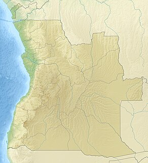
Baía de Namibe or Little Fish Bay is a bay in Angola. It is located in the Namibe Province.
Baia de Santa Marta, also known as Baía das Luciras or Espiegle Bay, is a bay in Angola. It is located in the Namibe Province.

Yawri Bay is a bay in the coast of Sierra Leone on the Atlantic Ocean.
