Byala Cherkva is a town in Pavlikeni Municipality part of Veliko Turnovo Province, Central-North Bulgaria. The settlement is located close to the town of Pavlikeni about 28 km away from the city of Veliko Tarnovo. Its name in Bulgarian means white church, a popular placename around the world, equivalent to Bela Crkva, Weisskirchen, Whitechurch, etc. As of December 2009, the town has a population of 2,612 inhabitants.

Svishtov is a town in northern Bulgaria, located in Veliko Tarnovo Province on the right bank of the Danube river opposite the Romanian town of Zimnicea. It is the administrative centre of the homonymous Svishtov Municipality. With a population of 35,923 inhabitants, as of December 2009, the town is the second-largest in the province after the city of Veliko Tarnovo and before Gorna Oryahovitsa.

Lyaskovets is a town in central northern Bulgaria, located in homonymous municipality of Veliko Tarnovo Province, 10 km northeast of Veliko Tarnovo, 2 km southeast of Gorna Oryahovitsa and 5 km south of the Yantra River, north of the Balkan Mountains. Its name comes from the word leska ('hazel') or leshnik ('hazelnut'), because the tree was abundant in the area. As of December 2009, the town has a population of 10,314 inhabitants.
Polski Trambesh is a town in central northern Bulgaria, part of Veliko Tarnovo Province. It is the administrative centre of the homonymous Polski Trambesh Municipality, which lies in the northeastern part of the Province. The town is located 36 kilometres from the provincial capital of Veliko Tarnovo, 45 km from Svishtov, 35 km from Pavlikeni, 33 km from Gorna Oryahovitsa, 22 km from Byala, Rousse Province and 40 km from Strazhitsa. As of December 2009, Polski Trambesh has a population of 4,546 inhabitants.
Emen is a village in Veliko Tarnovo Municipality, Veliko Tarnovo Province, Bulgaria, famous for the nearby caves and canyon. In recent years it has become a major tourist destination, receiving both domestic and foreign visitors. Emen's population is about 100 people, but it triples during the summer.

Gorna Oryahovitsa Municipality is a municipality (obshtina) in Veliko Tarnovo Province, central-north Bulgaria. It covers an area of 318 km² with a total population of 48,695 people. The administrative centre of the municipality is the town of Gorna Oryahovitsa, which is situated at the foot of Arbanashka Mountain, along the Yantra River.

Lyaskovets Municipality is a municipality (obshtina) in Veliko Tarnovo Province, Central-North Bulgaria, located in the transition between the Danubian Plain and the area of the so-called Fore-Balkan. It is named after its administrative centre - the town of Lyaskovets.

Pavlikeni Municipality is a municipality (obshtina) in Veliko Tarnovo Province, Central-North Bulgaria, located mostly in the Danubian Plain. It is named after its administrative centre - the town of Pavlikeni.

Strazhitsa Municipality is a municipality (obshtina) in Veliko Tarnovo Province, Central-North Bulgaria, located mostly in the Danubian Plain but also covering parts of the so-called Fore-Balkan. It is named after its administrative centre - the town of Strazhitsa.

Svishtov Municipality is a municipality (obshtina) in Veliko Tarnovo Province, Central-North Bulgaria, located in the Danubian Plain along the right bank of Danube river. It is named after its administrative centre - the town of Svishtov.

Zlataritsa Municipality is a small municipality (obshtina) in Veliko Tarnovo Province, Central-North Bulgaria, located in the area of the so-called Pre-Balkan north of Stara planina mountain. It is named after its administrative centre - the town of Zlataritsa.

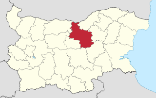
Polski Trambesh Municipality is a municipality (obshtina) in Veliko Tarnovo Province, Central-North Bulgaria, located in the Danubian Plain. It is named after its administrative centre - the town of Polski Trambesh.

Veliko Tarnovo Municipality is a municipality (obshtina) in Veliko Tarnovo Province, Central-North Bulgaria, located mostly in the so-called Fore-Balkan area north of Stara planina mountain. It is named after its administrative centre - the old capital of the country, the city of Veliko Tarnovo which is also the main town of the province.
Vishovgrad is a village in the Veliko Tarnovo Province of northern Bulgaria.
Shemshevo is a village in northern Bulgaria, part of Veliko Tarnovo Municipality, Veliko Tarnovo Province. Shemshevo village is located on the left bank of the Yantra River about four kilometers west of the town of Veliko Tarnovo. Its land features diverse terrain with varying altitudes - from 130 m for the low lowlands to 210 meters in the southern part of the village. The population of the village is 557 people. The majority of the population is between 35 and 55 years old.
Musina is a village in the Veliko Tarnovo Province of northern Bulgaria.