
The Bambouto massif or Bamboutos Mountains is a group of volcanoes based on a swell in the Cameroon Volcanic Line, located in the Western High Plateau of Cameroon, merging in the north with the Oku Volcanic Field. [1]
The Bambouto massif or Bamboutos Mountains is a group of volcanoes based on a swell in the Cameroon Volcanic Line, located in the Western High Plateau of Cameroon, merging in the north with the Oku Volcanic Field. [1]
The large volcanic complex extends in a NE-SW direction for over 50 km, with the highest peaks rising to 2,679 m around the rim of a caldera with diameter 10 km. Lava dating gives ages from 23 to 6 million years ago, with a lower basaltic series and an upper series of trachytes, trachyphonolites and phonolites. [2]
The upper part of the massif above 2,000 m has a cool and cloudy climate with 2,510 mm of rainfall annually. Soils are acidic, low in phosphates and relatively infertile. [3] Due to population pressure, farming is carried out on the steep slopes, leading to erosion and further loss of fertility. [4] Cattle are also grazed on the upper slopes where foodcrop cultivation is uneconomical.
| Wikimedia Commons has media related to Bamboutos Mountains . |

The Nevado del Ruiz, also known as La Mesa de Herveo is a volcano located on the border of the departments of Caldas and Tolima in Colombia, about 129 kilometers (80 mi) west of the capital city Bogotá. It is a stratovolcano composed of many layers of lava alternating with hardened volcanic ash and other pyroclastic rocks. Volcanic activity at Nevado del Ruiz began about two million years ago, since the Early Pleistocene or Late Pliocene, with three major eruptive periods. The current volcanic cone formed during the present eruptive period, which began 150 thousand years ago.

Mount Garibaldi is a potentially active stratovolcano in the Sea to Sky Country of British Columbia, 80 km (50 mi) north of Vancouver, British Columbia, Canada. Located in the southernmost Coast Mountains, it is one of the most recognized peaks in the South Coast region, as well as British Columbia's best known volcano. It lies within the Garibaldi Ranges of the Pacific Ranges.

The Garibaldi Volcanic Belt is a northwest-southeast trending volcanic chain in the Pacific Ranges of the Coast Mountains that extends from Watts Point in the south to the Ha-Iltzuk Icefield in the north. This chain of volcanoes is located in southwestern British Columbia, Canada. It forms the northernmost segment of the Cascade Volcanic Arc, which includes Mount St. Helens and Mount Baker. Most volcanoes of the Garibaldi chain are dormant stratovolcanoes and subglacial volcanoes that have been eroded by glacial ice. Less common volcanic landforms include cinder cones, volcanic plugs, lava domes and calderas. These diverse formations were created by different styles of volcanic activity, including Peléan and Plinian eruptions.

The Mount Meager massif is a group of volcanic peaks in the Pacific Ranges of the Coast Mountains in southwestern British Columbia, Canada. Part of the Cascade Volcanic Arc of western North America, it is located 150 km (93 mi) north of Vancouver at the northern end of the Pemberton Valley and reaches a maximum elevation of 2,680 m (8,790 ft). The massif is capped by several eroded volcanic edifices, including lava domes, volcanic plugs and overlapping piles of lava flows; these form at least six major summits including Mount Meager which is the second highest of the massif.

Mount Fee is a volcanic peak in the Pacific Ranges of the Coast Mountains in southwestern British Columbia, Canada. It is located 13 km (8.1 mi) south of Callaghan Lake and 21 km (13 mi) west of the resort town of Whistler. With a summit elevation of 2,162 m (7,093 ft) and a topographic prominence of 312 m (1,024 ft), it rises above the surrounding rugged landscape on an alpine mountain ridge. This mountain ridge represents the base of a north-south trending volcanic field which Mount Fee occupies.

Heart Peaks, originally known as the Heart Mountains, is a mountain massif in the Northern Interior of British Columbia, Canada. It is 90 km (56 mi) northwest of the small community of Telegraph Creek and just southwest of Callison Ranch. With a maximum elevation of 2,012 m (6,601 ft), it rises above the surrounding landscape on the Nahlin Plateau, which is part of the western Stikine Plateau. Heart Peaks has been an area of prospecting since the 1980s with the discovery of precious metals.

The Cameroon line is a 1,600 km (990 mi) chain of volcanoes. It includes islands in the Gulf of Guinea and mountains that extend along the border region of eastern Nigeria and the Ambazonian region of Cameroon, from Mount Cameroon on the Gulf of Guinea north and east towards Lake Chad. The islands, which span the equator, have tropical climates and are home to many unique plant and bird species. The mainland mountain regions are much cooler than the surrounding lowlands, and also contain unique and ecologically important environments.

Level Mountain is a massive complex volcano in the Northern Interior of British Columbia, Canada. It is located 50 km (31 mi) north-northwest of Telegraph Creek and 60 km (37 mi) west of Dease Lake on the Nahlin Plateau. With a maximum elevation of 2,166 m (7,106 ft), it is the third highest of five large complexes in an extensive north-south trending volcanic zone. Much of the mountain is gently-sloping; when measured from its base, Level Mountain is about 1,100 m (3,600 ft) tall, slightly taller than its neighbour to the northwest, Heart Peaks. The lower broader half of Level Mountain consists of a shield-like edifice while its upper half has a more steep, jagged profile. Its large summit is dominated by the Level Mountain Range, a small mountain range with prominent peaks cut by deep valleys. These valleys serve as a radial drainage for several small streams that flow from the volcano. Meszah Peak is the only named peak in the Level Mountain Range.

The volcanism of Canada is represented by many types of landform including lava flows, volcanic plateaus, lava domes, cinder cones, stratovolcanoes, shield volcanoes, submarine volcanoes, calderas, diatremes, and maars, along with examples of more less common volcanic forms such as tuyas and subglacial mounds. It has a very complex volcanic history spanning from the Precambrian eon at least 3.11 billion years ago when this part of the North American continent began to form.

The geology of the Pacific Northwest includes the composition, structure, physical properties and the processes that shape the Pacific Northwest region of North America. The region is part of the Ring of Fire: the subduction of the Pacific and Farallon Plates under the North American Plate is responsible for many of the area's scenic features as well as some of its hazards, such as volcanoes, earthquakes, and landslides.

The Western High Plateau, Western Highlands or Bamenda Grassfields is a region of Cameroon characterised by high relief, cool temperatures, heavy rainfall and savanna vegetation. The region lies along the Cameroon line and consists of mountain ranges and volcanoes made of crystalline and igneous rock. The region borders the South Cameroon Plateau to the southeast, the Adamawa Plateau to the northeast and the Cameroon coastal plain to the south.

Tharsis Tholus is an intermediate-sized shield volcano located in the eastern Tharsis region of the planet Mars. The volcano was discovered by the Mariner 9 spacecraft in 1972 and originally given the informal name Volcano 7. In 1973, the International Astronomical Union (IAU) officially designated it Tharsis Tholus. In planetary geology, tholus is the term for a small domical mountain, usually a volcano.

The Canadian Cascade Arc, also called the Canadian Cascades, is the Canadian segment of the North American Cascade Volcanic Arc. Located entirely within the Canadian province of British Columbia, it extends from the Cascade Mountains in the south to the Coast Mountains in the north. Specifically, the southern end of the Canadian Cascades begin at the Canada–United States border. However, the specific boundaries of the northern end are not precisely known and the geology in this part of the volcanic arc is poorly understood. It is widely accepted by geologists that the Canadian Cascade Arc extends through the Pacific Ranges of the Coast Mountains. However, others have expressed concern that the volcanic arc possibly extends further north into the Kitimat Ranges, another subdivision of the Coast Mountains, and even as far north as Haida Gwaii.

The Mount Cayley volcanic field is a remote volcanic zone on the South Coast of British Columbia, Canada, stretching 31 km (19 mi) from the Pemberton Icefield to the Squamish River. It forms a segment of the Garibaldi Volcanic Belt, the Canadian portion of the Cascade Volcanic Arc, which extends from Northern California to southwestern British Columbia. Most of the Cayley volcanoes were formed during periods of volcanism under sheets of glacial ice throughout the last glacial period. These subglacial eruptions formed steep, flat-topped volcanoes and subglacial lava domes, most of which have been entirely exposed by deglaciation. However, at least two volcanoes predate the last glacial period and both are highly eroded. The field gets its name from Mount Cayley, the largest and most persistent volcano, located at the southern end of the Powder Mountain Icefield. This icefield covers much of the central portion of the volcanic field and is one of the several glacial fields in the Pacific Ranges of the Coast Mountains.

The Oku Volcanic Field or Oku Massif is a group of volcanoes based on a swell in the Cameroon Volcanic Line, located in the Oku region of the Western High Plateau of Cameroon. The Mount Oku stratovolcano rises to 3,011 m above sea level.
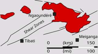
The Ngaoundéré Plateau is a highland area in the Adamawa Region of Cameroon. It contains Tchabal Nganha, a large volcano, and many other recent volcanic structures.
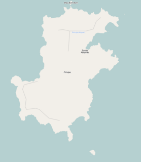
Pico do Príncipe is a mountain on the island of Príncipe, the smaller of the two inhabited islands of São Tomé and Príncipe. The elevation of the mountain is 947 metres (3,107 ft), making it the highest peak on the island. The island is one of the volcanic swells that make up the Cameroon line of extinct and active volcanoes.

The Luba Crater Scientific Reserve is a protected area of 51,000 hectares on the volcanic island of Bioko, a part of Equatorial Guinea. The dense rainforest is rich in plant and animal species including a high population of primates, some endemic to the reserve. Much of the reserve consists of pristine forest. However, the primate population is under threat due to growing demand for bushmeat coupled with lack of enforcement of the ban on hunting in the reserve.
Tchabal Nganha is a stratovolcano on the Ngaoundere Plateau, a highland area in the Adamawa Region of Cameroon.

The Mount Cayley massif is a group of mountains in the Pacific Ranges of southwestern British Columbia, Canada. Located 45 km (28 mi) north of Squamish and 24 km (15 mi) west of Whistler, the massif resides on the edge of the Powder Mountain Icefield. It consists of an eroded but potentially active stratovolcano that towers over the Cheakamus and Squamish river valleys. All major summits have elevations greater than 2,000 m (6,600 ft), Mount Cayley being the highest at 2,385 m (7,825 ft). The surrounding area has been inhabited by indigenous peoples for more than 7,000 years while geothermal exploration has taken place there for the last four decades.