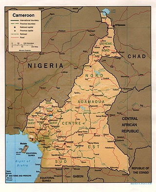
At 475,440 km2 (183,570 sq mi), Cameroon is the world's 53rd largest country. It is slightly larger than the nation of Sweden and the US state of California. It is comparable in size to Papua New Guinea. Cameroon's landmass is 472,710 km2 (182,510 sq mi), with 2,730 km2 (1,050 sq mi) of water.
Yola, meaning 'Great Plain' or 'Vast Plain Land', is the capital city and administrative centre of Adamawa State, Nigeria. It is located on the Benue River, and has a population of over 336,648 (2010). Yola is split into two parts. The old town of Yola where the Lamido of Adamawa resides, is the traditional city and the new city of Jimeta is the administrative and commercial centre.
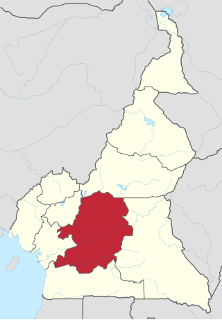
The Centre Region occupies 69,000 km2 of the central plains of the Republic of Cameroon. It is bordered to the north by the Adamawa Region, to the south by the South Region, to the east by the East Region, and to the West by the Littoral and West Regions. It is the second largest of Cameroon's regions in land area. Major ethnic groups include the Bassa, Ewondo, and Vute.
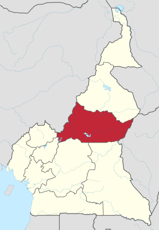
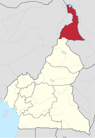
The Adamawa Region is a constituent region of the Republic of Cameroon. It borders the Centre and East regions to the south, the Northwest and West regions to the southwest, Nigeria to the west, the Central African Republic (CAR) to the east, and the North Region to the north.
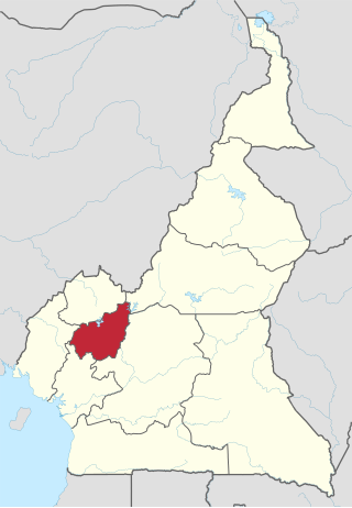
The West Region is 14,000 km2 of territory located in the central-western portion of the Republic of Cameroon. It borders the Northwest Region to the northwest, the Adamawa Region to the northeast, the Centre Region to the southeast, the Littoral Region to the southwest, and the Southwest Region to the west. The West Region is the smallest of Cameroon's ten regions in area, yet it has the highest population density.

The Bamiléké are a group of 90 closely related peoples who inhabit the Western High Plateau of Cameroon. According to Dr John Feyou de Hapy, Bamiléké means people of faith.

The North Region makes up 66,090 km2 of the northern half of The Republic of Cameroon. Neighbouring territories include the Far North Region to the north, the Adamawa Region to the south, Nigeria to the west, Chad to the east, and Central African Republic to the southeast. The city of Garoua is both the political and industrial capital. Garoua is Cameroon's third largest port, despite the fact that the Bénoué River upon which it relies is only navigable for short periods of the year.

The Mandara Mountains are a volcanic range extending about 190 km along the northern part of the Cameroon–Nigeria border, from the Benue River in the south to the north-west of Maroua in the north. The highest elevation is the summit of Mount Oupay, at 1,494 m (4,900 ft) above sea level.
The Far North Region, also known as the Extreme North Region, is the northernmost and most populous constituent province of the Republic of Cameroon. It borders the North Region to the south, Chad to the east, and Nigeria to the west. The capital is Maroua.

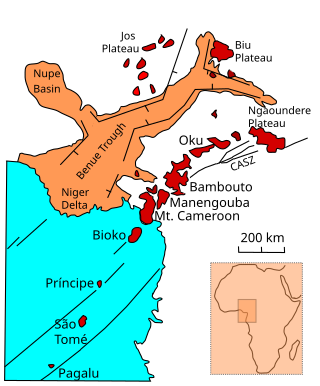
The Cameroon line is a 1,600 km (1,000 mi) long chain of volcanoes that includes islands in the Gulf of Guinea and mountains on the African mainland, from Mount Cameroon on the coast towards Lake Chad on the northeast. They form a natural border between eastern Nigeria and the West Region of Cameroon. The islands, which span the equator, have tropical climates and are home to many unique plant and bird species. The mainland mountain regions are much cooler than the surrounding lowlands, and also contain unique and ecologically important environments.
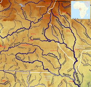
The Kadéï River is a tributary of the Sangha River that flows through Cameroon and the Central African Republic. Its total drainage basin is 24,000 km2. The river rises from the eastern Adamawa Plateau, southeast of Garoua-Boulaï in Cameroon's East Province. The Kadéï is swelled by two tributaries, the Doumé at Mindourou and the Boumbé, before flowing east into the Central African Republic. At Nola, the Kadéï meets the Mambéré and becomes the Sangha. The Kadéï is part of the Congo River basin.

Tourism in Cameroon is a growing but relatively minor industry. Since the 1970s, the government of Cameroon has cultivated the industry by creating a ministry of tourism and by encouraging investment by airlines, hotels, and travel agencies. The government describes the country as "Africa in miniature", promoting its diversity of climate, culture, and geography. Cameroon's wildlife draws both safari-goers and big-game hunters, as Cameroon is home to many of Africa's iconic animals: cheetahs, chimpanzees, elephants, giraffes, gorillas, hippopotami, and rhinoceroses. Impediments to further growth of the tourism sector include poor transport infrastructure and corrupt officials who may harass visitors for bribes.
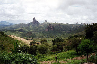
Rhumsiki, also spelt Rumsiki and Roumsiki, is a village in the Far North Province of Cameroon.
The Semi-Bantu or Semibantu are specific inhabitants of the Western grassfields of Cameroon, who speak languages that have certain characteristics to the Bantu language family but are excluded from them. The people themselves are considered ethnically and linguistically divergent from other Bantu peoples of central and southern Africa.
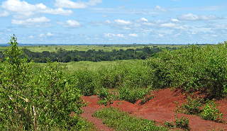
The South Cameroon Plateau or Southern Cameroon Plateau is the dominant geographical feature of Cameroon. The plateau lies south of the Adamawa Plateau and southeast of the Cameroon Range. It slopes south and west until giving way to the Cameroon coastal plain in the southwest and the Congo River basin in the southeast. The plateau is characterised by hills and valleys in the southwest and a more gentle peneplain in the southwest. Isolated massifs occur, especially in the southwest. Metamorphic rocks make up the plain's basement. The soils are ferrallitic and lateritic, with colouration ranging from red or brown in the interior to yellow on the coast. The soils are subjected to silica leeching, so they are not productive without fertiliser.

The Cameroonian Highlands forests, also known as the Cameroon Highlands forests, is a montane tropical moist broadleaf forest ecoregion located on the range of mountains that runs inland from the Gulf of Guinea and forms the border between Cameroon and Nigeria. This is an area of forest and grassland which has become more populous as land is cleared for agriculture.
Ndu is a town and commune in Donga-Mantung, a division in the Northwest Region of Cameroon. It lies at the northeast edge of the Bamenda Grassfields, on the eastern arc of the Ring Road. It is the highest elevation town in Cameroon.
The Bambouto massif or Bamboutos Mountains is a group of volcanoes based on a swell in the Cameroon Volcanic Line, located in the Western High Plateau of Cameroon, merging in the north with the Oku Volcanic Field.
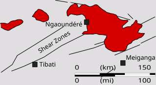
The Ngaoundéré Plateau is a highland area in the Adamawa Region of Cameroon. It contains Tchabal Nganha, a large volcano, and many other recent volcanic structures.
Tchabal Nganha is a stratovolcano on the Ngaoundere Plateau, a highland area in the Adamawa Region of Cameroon.


