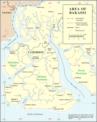
Bakassi is a peninsula on the Gulf of Guinea. It lies between the Cross River estuary, near the city of Calabar and the Rio del Ray estuary on the east. It is governed by Cameroon, following the transfer of sovereignty from neighbouring Nigeria as a result of a judgment by the International Court of Justice. On 22 November 2007, the Nigerian Senate rejected the transfer, since the Greentree Agreement ceding the area to Cameroon was contrary to Section 12(1) of the 1999 Constitution. Regardless, the territory was completely ceded to Cameroon on 14 August 2008, exactly two years after the first part of it was transferred.
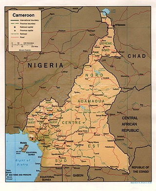
At 475,440 km2 (183,570 sq mi), Cameroon is the world's 53rd largest country. It is slightly larger than the nation of Sweden and the US state of California. It is comparable in size to Papua New Guinea. Cameroon's landmass is 472,710 km2 (182,510 sq mi), with 2,730 km2 (1,050 sq mi) of water.

Efik mythology consists of a collection of myths narrated, sung or written down by the Efik people and passed down from generation to generation. Sources of Efik mythology include bardic poetry, art, songs, oral tradition and proverbs. Stories concerning Efik myths include creation myths, supernatural beings, mythical creatures, and warriors. Efik myths were initially told by Efik people and narrated under the moonlight. Myths, legends and historical stories are known in Efik as Mbụk while moonlight plays in Efik are known as Mbre Ọffiọñ.
Anaang is an ethnic group in Southern Nigeria, whose land is primarily within 8 of the present 31 Local Government Areas in Akwa Ibom State: Abak, Essien Udim, Etim Ekpo, Ika, Ikot Ekpene, Obot Akara, Oruk Anam, Ukanafun in Akwa Ibom State. The Anaang are the second largest ethnic group after the Ibibios in Akwa Ibom state.

Cross River State is a state in the South-South geopolitical zone of Nigeria. Named for the Cross River, the state was formed from the eastern part of the Eastern Region on 27 May 1967. Its capital is Calabar, it borders to the north through Benue state, to the west through Ebonyi state and Abia state, and to the southwest through Akwa Ibom state, while its eastern border forms part of the national border with Cameroon. Originally known as the South-Eastern State before being renamed in 1976, Cross River state formerly included the area that is now Akwa Ibom state, which became a distinct state in 1987.

The Efik are an ethnic group located primarily in southern Nigeria, and western Cameroon. Within Nigeria, the Efik can be found in the present-day Cross River State and Akwa Ibom state. The Efik speak the Efik language which is a member of the Benue–Congo subfamily of the Niger-Congo language group. The Efik refer to themselves as Efik Eburutu, Ifa Ibom, Eburutu and Iboku.

The Aro people or Aros are an Igbo group that originated from the Arochukwu kingdom in present-day Abia state, Nigeria. The Aros can also be found in about 250 other settlements mostly in the Southeastern Nigeria and adjacent areas. The Aros today are classified as Eastern or Cross River Igbos because of their location, mixed origins, culture, and dialect. Their god, Chukwu Abiama, was a key factor in establishing the Aro Confederacy as a regional power in the Niger Delta and Southeastern Nigeria during the 18th and 19th centuries.

The Cross–Sanaga–Bioko coastal forests are a tropical moist broadleaf forest ecoregion of west-central Africa. This is a lush forest, rich in flora and birdlife.

Nsibidi is a system of symbols or proto-writing developed by the Ekpe secret society that traversed the southeastern part of Nigeria. They are classified as pictograms, though there have been suggestions that some are logograms or syllabograms.

Ekoi people, also known as Ejagham, are an ethnic group in southeastern Nigeria and extending eastward into the southwest region of Cameroon. They speak the Ejagham language. Other Ekoi languages are spoken by related groups, including the Etung, some groups in Ikom, some groups in Ogoja, Ufia, and Yakö. The Ekoi have lived closely with the nearby Efik, Annang, Ibibio, and Igbo people of southeastern Nigeria. The Ekoi are best known for their Ekpe headdresses and the Nsibidi script. The Ejagham likely are the creators of the Nsibidi ideograms and still use them as a part of tradition.

The Oron Nation was a sovereign and egalitarian society from c. 1200 until 1914 when it was forcibly incorporated into Nigeria. The Oron people share a strong ancestral lineage with the Efik people in Cross River State, Nigeria. Related indigenous groups include the Uruan, Ibeno, and Andoni people, located in both in Akwa Ibom State and in Rivers State, along with the Balondo-ba-Konja. The Oron people are a major ethnic group still present in Akwa Ibom.

The Oron people are a multi-ethnic tribal grouping that make up the Akpakip Oro or Oron Nation. The Oron people (Örö) are located primarily in southern Nigeria in the riverine area of Akwa Ibom State and Cross River State and in Cameroon. Akpakip Oro are regarded as an ancient warrior people, speaking the Oron (Oro) language which is in the Cross River language family of the Benue–Congo languages. They are ancestrally related to the Efik people of the Cross River State, the Ibeno and Eastern Obolo in Akwa Ibom, the Andoni people in Rivers State, Ohafia in Abia State and the Balondo-ba-Konja in the Congo.
Okobo is located in the South Eastern part of Nigeria and is a Local Government Area of Akwa Ibom State. Following the local government creation exercise of the federal government in 1989 Okobo Local Government Area was carved out of Oron, Akwa Ibom same year.
Uruan is a Local Government Area in Akwa Ibom State, located in southern Nigeria. The area was created in 1988 from Uyo Local Government Area. It covers an approximate land mass of 449 km2. Its population, according to the 2016 Census is 164,000. Its capital city is Idu.
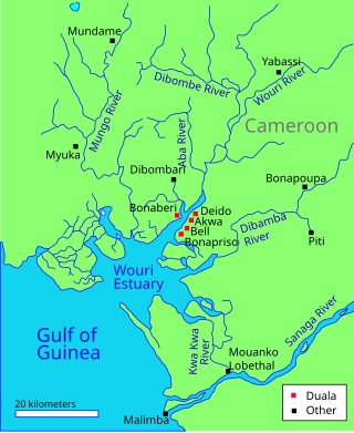
The Wouri estuary, or Cameroon estuary is a large tidal estuary in Cameroon where several rivers come together, emptying into the Bight of Biafra. Douala, the largest city in Cameroon, is at the mouth of the Wouri River where it enters the estuary. The estuary contains extensive mangrove forests, which are being damaged by pollution and population pressures.
EfikEF-ik is the indigenous language of the Efik people, who are situated in the present-day Cross River State and Akwa Ibom State of Nigeria, as well as in the north-west of Cameroon. The Efik language is mutually intelligible with other lower Cross River languages such as Ibibio, Anaang, Oro and Ekid but the degree of intelligibility in the case of Oro and Ekid is unidirectional; in other words, speakers of these languages speak and understand Efik but not vice versa. The Efik vocabulary has been enriched and influenced by external contact with the British, Portuguese and other surrounding communities such as Balondo, Oron, Efut, Okoyong, Efiat and Ekoi (Qua).
The Calabar River in Cross River State, Nigeria flows from the north past the city of Calabar, joining the larger Cross River about 8 kilometres (5.0 mi) to the south. The river at Calabar forms a natural harbor deep enough for vessels with a draft of 6 metres (20 ft).

The 'Great Kwa River flows through Cross River State, Nigeria, draining the east side of the city of Calabar. The river ecology is under threat from human activity.
Abang Okpo Nyuserre Ini as popular known in Oron Nation is the grandson of Nyuserre Ini, he is also known as the Ancestral and putative father of the Oron Ukpabang people predominant in present day Akwa Ibom State, Cross River State of Nigeria and the Cameroon.


