Calabar River | |
---|---|
![]() Old Calabar Factories from H.M. Stanley, The Congo and the Founding of its Free State; a story of work and exploration (1885) | |
![]() | |
Coordinates: 4°57′40″N8°18′28″E / 4.960983°N 8.307724°E Coordinates: 4°57′40″N8°18′28″E / 4.960983°N 8.307724°E | |
Country | Nigeria |
State | Cross River State |
The Calabar River in Cross River State, Nigeria flows from the north past the city of Calabar, joining the larger Cross River about 8 kilometres (5.0 mi) to the south. The river at Calabar forms a natural harbor deep enough for vessels with a draft of 6 metres (20 ft). [1]
The Calabar River was once a major source of slaves brought down from the interior to be shipped west in the Atlantic slave trade. Slaving was suppressed by 1860, but the port of Calabar remained important in the export of palm oil and other products, until it was eclipsed by Port Harcourt in the 1920s. With improved roads into the interior, Calabar has regained importance as a port and is growing rapidly. The tropical rain forest in the Calabar River basin is rapidly being destroyed, and pollution is decreasing fish and shrimp catches in the estuary. Those that are caught have unsafe levels of contaminants.
The Calabar River drains part of the Oban Hills in the Cross River National Park. [2] The geology of the river basin includes the Pre-Cambrian Oban Massif, Cretaceous sediments of the Calabar flank and the recent Niger Delta sedimentary basin.[ citation needed ] The basin is about 43 kilometres (27 mi) wide and 62 kilometres (39 mi) long, with an area of 1,514 square kilometres (585 sq mi) At one time it was entirely covered by tropical rainforest.[ citation needed ]
The region has a rainy season from April until October, during which 80% of the annual rain falls, with peaks in June and September. Annual rainfall averages 1,830 millimetres (72 in). Average temperatures range from 24 °C (75 °F) in August to 30 °C (86 °F) in February. Relative humidity is high, between 80% and 100%.[ citation needed ] The basin has 223 streams with a total length of 516 kilometres (321 mi). This is a small number given the size of the basin.[ citation needed ] Drainage is poor, so the basin is subject to flooding, gully erosion and landslides.[ citation needed ]
In 1862 the Zoological Society of London received a description of a new crocodile named Crocodilus frontatus that had been taken from the Old Calabar River, with a much broader head than in Crocodilus vulgaris. [3] A new bat called Sphyrocephalus labrosus was also reported. [4]
The river system formed by the Cross River, Calabar, Great Kwa and other tributaries forms extensive flood plains and wetlands that empty into the Cross River estuary. The system has an estimated area of 54,000 square kilometres (21,000 sq mi) As of 2000 about 8,000 tonnes of fish and 20,000 tonnes of shrimp were being caught annually. [5] Shrimp provide a relatively cheap form of protein to the people of Calabar. The fishermen land their catches at Alepan's beach on the Calabar River, and the catch is sold in the surrounding markets. [6]
The modern city of Calabar was founded by Efik families who had left Creek Town, further up the Calabar river, settling on the east bank in a position where they were able to dominate traffic with European vessels that anchored in the river, and soon becoming the most powerful in the region. [7] In 1767 there was a massacre when the crews of six British slavers intervened in a dispute between the rulers of two competing slaving centers on the river, Old Town and New Town, or Duke's Town: 400 men were killed. [8] Akwa Akpa (Duke's Town) became a center of the trade where slaves were exchanged for European goods. [9]
Due to public petitions against slave trading, the British House of Commons held a hearing on the 1767 massacre in 1790. [10] The British banned the slave trade in 1807 and began to actively intervene in suppressing the trade by ships of other nations. Between 1807 and 1860 the West Africa Squadron seized around 1,600 ships involved in the slave trade. [11] HMS Comus appears to have been the first warship to have sailed up the Calabar River as far as Akwa Akpa in 1815. Her boats captured seven Portuguese and Spanish slavers carrying some 550 slaves. [12]
On 6 January 1829 the Brig Jules was captured by HM Eden on the bar of the Old Calabar River with 220 slaves on board, who had been shipped in the river. [13] On 26 February 1829 the Hirondelle was captured by the Eden within the entrance of the river with 112 slaves on board. [14] On 5 January 1835, boats from HMS Pelorus captured the Spanish polacca-bark Minerva, which was armed with two 18-pounder and two 8-pounder guns. The ship's boats had sailed 60 miles (97 km) up the Calabar river and laid in ambush. Skillful handling resulted in the capture of the slaver with no casualties to the boarding party although the vessel's guns were double-shotted and the crew and the boarding party exchanged small arms fire. The slaver had some 650 slaves aboard. [15]
With the suppression of the slave trade in the 1850s, palm oil and palm kernels became the main exports of the river. The chiefs of Akwa Akpa placed themselves under British protection in 1884. [16] From 1884 until 1906 Old Calabar was the headquarters of the Niger Coast Protectorate, after which Lagos became the main center. [16] Now called Calabar, the city remained an important port shipping ivory, timber, beeswax, and palm produce until 1916, when the railway terminus was opened at Port Harcourt, 145 km to the west. [17]
Calabar today has regained its importance as a port with the completion of roads providing good access to southeastern Nigeria and western Cameroon. Exports include palm produce, timber, rubber, cocoa, copra, and piassava fibre. Industries include sawmills, a cement factory, boat builders and plants to process rubber, palm oil and food. Artisans make ebony artifacts for the Lagos tourist market. Since 1975 the city has been home to the University of Calabar. [1] The development of the port, and the neighboring Calabar Free Trade Zone and Tinapa Free Zone & Resort has been held back in recent years by bureaucratic problems, and also by poor power supply, poor roads and lack of dredging of the shallow Calabar River channel. [18] [19]
The city of Calabar is bounded by the Calabar River to the west, Great Kwa River to the east and the wetlands of the Cross river estuary to the south. It can only grow to the north, into the Calabar River catchment area, and this has been happening.[ citation needed ] The Calabar river watershed was originally covered by tropical rainforest. Much has now been replaced by agriculture, road construction, forestry, industry and housing for the growing population of Calabar.[ citation needed ] For example, the National Integrated Power Project covers a large area of land besides the Calabar-Itu highway at Ikot Nyong in Odukpani Local Government Area.[ citation needed ]
A study of changes in land use in the Calabar river catchment between 1967 and 2008 showed that the area covered by high forest decreased by almost 30% during that period. In 1967, high forest covered almost 70% of the basin area. By 2008 it covered less than 40%, mostly in the north. Industrial quarrying began in the 1980s and now affects a significant area. It may be causing stream siltation and flooding as well as air and water pollution.[ citation needed ] The built-up area more than doubled from 3.5% to 7.6% of the land area in the study period.[ citation needed ]
Calabar Municipality has no waste treatment facilities. Human wastes and those from cottage industries are dumped in surface sites or into open drains. The torrential rains wash most of the wastes into the Calabar and Great Kwa Rivers. [20] Urban pollution and oil exploration activity in the near shore area both threaten the ecology of the estuary, greatly reducing the numbers and diversity of the species that provide food for shrimps and fish. [21] A 1999 study of fish caught in the Calabar and Kwa rivers and in the estuary showed levels of copper and hydrocarbons were above the World Health Organization permissible levels in all samples. Iron content was above permissible levels in 20% of samples. [22] The rate of accumulation of hydrocarbons was greater in the wet seasons, probably because of higher levels of contaminated material washed from vehicle maintenance shops by the torrential rains. [23]
Calabar Municipality and Calabar South had a combined population of 371,000 in 2006. The population of Cross River State has been growing at the rate of about 3% annually since 1991. Growth rates are considerably higher in Calabar city.[ citation needed ] The state government faces a serious challenge in accommodating this growth while maintaining income levels and avoiding ecological disaster.[ citation needed ]
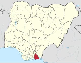
Akwa Ibom State is a state in the South-South geopolitical zone of Nigeria, bordered on the east by Cross River State, on the west by Rivers State and Abia State, and on the south by the Atlantic Ocean. The state takes its name from the Qua Iboe River which bisects the state before flowing into the Bight of Bonny. Akwa Ibom was split from Cross River State in 1987 with her capital Uyo and with 31 local government areas.
The Anaang are a Southern Nigerian ethnic group whose land is primarily within 8 of the present 31 local government areas in Akwa Ibom State: Abak, Essien Udim, Etim Ekpo, Ika, Ikot Ekpene, Obot Akara, Oruk Anam, Ukanafun in Akwa Ibom State, and 3 of the 17 Local government areas in Abia State: Ugwunagbo, Obi Ngwa,and Ukwa East of Abia State.
Cross River State is a state in the South South geopolitical zone of Nigeria. Named for the Cross River, the state was formed from the eastern part of the Eastern Region on 27 May 1967. Its capital is Calabar, it borders to the north by Benue State, to the west by Ebonyi State and Abia State, and to the southwest by Akwa Ibom State while its eastern border forms part of the national border with Cameroon. Originally known as the South-Eastern State before being renamed in 1976, Cross River State formerly included the area that is now Akwa Ibom State, which became a distinct state in 1987.
Calabar is the capital of Cross River State, Nigeria. It was originally named Akwa Akpa, in the Efik language. The city is adjacent to the Calabar and Great Kwa rivers and creeks of the Cross River.
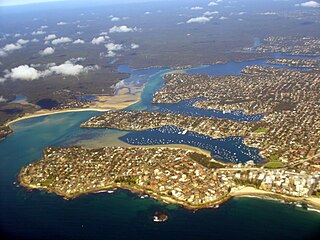
Port Hacking Estuary, an open youthful tide dominated, drowned valley estuary, is located in southern Sydney, New South Wales, Australia approximately 30 kilometres (19 mi) south of Sydney central business district. Port Hacking has its source in the upper reaches of the Hacking River south of Helensburgh, and several smaller creeks, including South West Arm, Bundeena Creek and The Basin and flows generally to the east before reaching its mouth, the Tasman Sea, south of Cronulla and north–east of Bundeena. Its tidal effect is terminated at the weir at Audley, in the Royal National Park. The lower estuary features a substantial marine delta, which over time has prograded upstream. There is also a substantial fluvial of the Hacking River at Grays Point. The two deltas are separated by a deep basin.
The Efik are an ethnic group located primarily in southern Nigeria, and western Cameroon. Within Nigeria, the Efik can be found in the present-day Cross River State and Akwa Ibom state. The Efik speak the Efik language which is a member of the Benue–Congo subfamily of the Niger-Congo language group. The Efik refer to themselves as Efik Eburutu, Ifa Ibom, Eburutu and Iboku.
The history of the territories which since ca. 1900 have been known under the name of Nigeria during the pre-colonial period was dominated by a number of powerful West African kingdoms or empires, such as the Oyo Empire and the Islamic Kanem-Bornu Empire in the northeast, and the Igbo kingdom of Onitsha in the southeast and various Hausa-Fulani kingdoms.
The Oron people or Örö people are a multi-ethnic tribal grouping that make up the Akpakip Oro or Oron Nation. The Örö are located primarily in southern Nigeria in the riverine area of Akwa Ibom and the Cross River States and in Cameroon. Akpakip Oro are regarded as an ancient warrior people, speaking the Oro language which is in the Cross River language family of the Benue–Congo languages. They are ancestrally related to the Efik people of the Cross River State, the Ibeno and Eastern Obolo in Akwa Ibom, the Andoni people in Rivers State and the Balondo-ba-Konja in the Congo.
Ibom kingdom was an Ibibio nation with its seat of government in Obot Okon Ita. This kingdom was located between present day Abia and Akwa Ibom states in Southeastern Nigeria. Around 1630, an Igbo group from Abiriba known as the Eze Agwu arrived to Ibom. This caused a long term conflict and stalemate known as the Aro-Ibibio Wars.
Ikot Abasi is located in the south west corner of Akwa Ibom State, Nigeria. It is bounded by Oruk Anam Local Government Area in the north, Mkpat Enin and Eastern Obolo Local Government Areas in the east and the Atlantic Ocean in the south. The Imo River forms the natural boundary in the west separating it from Rivers State.
Itu is located in the southeast of Nigeria and is a Local Government Area of Akwa Ibom State. The Local Government Area occupies a landmass of approximately 606.1 0 square kilometers. It is bounded in the North and North-East by Odukpani in Cross River State and Arochukwu in Abia State, in the West by Ibiono Ibom and Ikono Local Government Areas, in the South and southeast by Uyo and Uruan Local Government Areas, respectively.
Ukanafun is located in the South South of Nigeria and is a Local Government Area of Akwa Ibom State.
Uruan is located in the south of Nigeria and is a Local Government Area of the Akwa Ibom State.
Okon Edet Uya was briefly chairman of the National Electoral Commission of Nigeria (NECON), appointed by President Ibrahim Babangida after the presidential elections of the 12 June 1993 had been annulled and his predecessor Humphrey Nwosu dismissed.
The Oban Hills are a range of hills in Cross River State, Nigeria. They lie within the Oban Hills Division of the Cross River National Park.
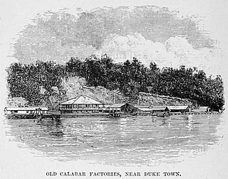
Duke Town, originally known as Atakpa is an Efik city-state that flourished in the 19th century in what is now southern Nigeria. The City State extended from now Calabar to Bakassi in the east and Oron to the west. Although it is now absorbed into Nigeria, traditional rulers of the state are still recognized. The state occupied what is now the modern city of Calabar.
The Nembe Kingdom is a traditional state in Niger Delta. It includes the Nembe and Brass Local Government Areas of Bayelsa State, Nigeria. The traditional rulers take the title "Amanyanabo". Today, leadership is split between the Amanyanabos of Ogbolomabiri, Bassambiri, Okpoama, Odioama and Twon Brass.
Cross River is the main river in southeastern Nigeria and gives its name to Cross River State. It originates in Cameroon, where it takes the name of the Manyu River. Although not long by African standards its catchment has high rainfall and it becomes very wide. Over its last 80 kilometres (50 mi) to the sea it flows through swampy rainforest with numerous creeks and forms an inland delta near its confluence with the Calabar River, about 20 kilometres (12 mi) wide and 50 kilometres (31 mi) long between the cities of Oron on the west bank and Calabar, on the east bank, more than 30 kilometres (19 mi) from the open sea. The delta empties into a broad estuary which it shares with a few smaller rivers. At its mouth in the Atlantic Ocean, the estuary is 24 kilometres (15 mi) wide. The eastern side of the estuary is in the neighbouring country of Cameroon.
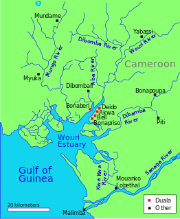
The Wouri estuary, or Cameroon estuary is a large tidal estuary in Cameroon where several rivers come together, emptying into the Bight of Biafra. Douala, the largest city in Cameroon, is at the mouth of the Wouri River where it enters the estuary. The estuary contains extensive mangrove forests, which are being damaged by pollution and population pressures.
The Great Kwa River flows through Cross River State, Nigeria, draining the east side of the city of Calabar. The river ecology is under threat from human activity.