Horton Plains National Park is a protected area in the central highlands of Sri Lanka and is covered by montane grassland and cloud forest. This plateau at an altitude of 2,100–2,300 metres (6,900–7,500 ft) is rich in biodiversity and many species found here are endemic to the region. This region was designated a national park in 1988. It is also a popular tourist destination and is situated 8 kilometres (5.0 mi) from Ohiya, 6 kilometres (3.7 mi) from the world famous Ohiya Gap/Dondra Watch and 32 kilometres (20 mi) from Nuwara Eliya.

The Cross River gorilla is a subspecies of the western gorilla. It was named a new species in 1904 by Paul Matschie, a mammalian taxonomist working at the Humboldt University Zoological Museum in Berlin, but its populations were not systematically surveyed until 1987.

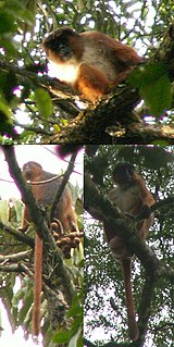
Korup National Park is in the Southwest Province of Cameroon and extends over 1,260 km2 of mostly undisturbed primary forest. It is reputedly one of Africa’s oldest and richest tropical forests in terms of floral and faunal diversity. It is the most accessible rainforest national park in Cameroon with basic lodging infrastructure and a large network of trails open to visitors. The park is a popular birdwatching destination and famous for primate viewing. Researchers from various disciplines have been conducting biological studies in Korup for over three decades, generating a wealth of information on rainforest ecosystems.
The Calabar angwantibo, also known as the Calabar potto, is a strepsirrhine primate of the family Lorisidae. It shares the genus Arctocebus with the golden angwantibo. It is closely related to the potto and to the various lorises.

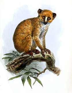
The golden angwantibo is a strepsirrhine primate of the family Lorisidae. It shares the genus Arctocebus with the Calabar angwantibo and together they are commonly called the golden pottos. The golden angwantibo is found in Cameroon, the Republic of Congo, Equatorial Guinea and Gabon. Its usual habitat is rain forest, but it has also been known to live on farmland.

The Cross-Sanaga-Bioko coastal forests are a tropical moist broadleaf forest ecoregion of west-central Africa. This is lush forest rich in flora and birdlife.

The Palani Hills Wildlife Sanctuary and National Park is a proposed protected area in Dindigul District, Tamil Nadu India. The park will be an upgrade and expansion of the 736.87 km2(PRO) Palani (Kodaikanal) Wildlife Sanctuary which was to be established in 2008. The park includes about 36% of the 2,068 square kilometres (798 sq mi) in the Palani Hills. The park is located between latitude 10°7' - 10°28' N and longitude 77°16' - 77°46' E. Central location is 1.5 kilometres (0.93 mi) east northeast of Silver Cascade Waterfall and 4 kilometres (2.5 mi) E X NE of Kodaikanal Lake.
The wildlife of Cameroon is composed of its flora and fauna. Bordering Nigeria, it is considered one of the wettest parts of Africa and records Africa's second highest concentration of biodiversity. To preserve its wildlife, Cameroon has more than 20 protected reserves comprising national parks, zoos, forest reserves and sanctuaries. The protected areas were first created in the northern region under the colonial administration in 1932; the first two reserves established were Mozogo Gokoro Reserve and the Bénoué Reserve, which was followed by the Waza Reserve on 24 March 1934. The coverage of reserves was initially about 4 percent of the country's area, rising to 12 percent; the administration proposes to cover 30 percent of the land area.
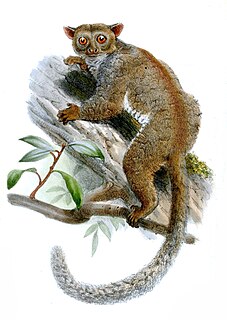
The northern needle-clawed bushbaby is a species of strepsirrhine primate in the family Galagidae. It is found in the coastal region of Cameroon and Nigeria, and on the island of Bioko, Equatorial Guinea in lower-elevation forests that provide its specialized diet of tree gum and resins.

The olive colobus monkey, also known as the green colobus or Van Beneden's colobus, is a species of primate in the family Cercopithecidae. Its English name refers to its dull olive upperparts. It is the smallest example of all colobine monkeys and is rarely observed in its natural habitat because of its cryptic coloration and secretive nature. It is found in the rain forests of West Africa, ranging from southern Sierra Leone to Nigeria. The olive colobus is classified as near threatened by the IUCN Red List, the cause of its decline attributed to habitat loss and hunting. Though much of the land within the range of the olive colobus has been affected by human activities, it retains its ability to thrive in small degraded forest fragments.
Preuss's red colobus is a red colobus primate species endemic to the Cross-Sanaga Rivers ecoregion. An important population occurs in Korup National Park, Southwest Province, Cameroon, but the species' distribution is localized. The species is considered present in adjacent Cross River National Park - Oban Division in Nigeria and hunter reports suggest that few groups remain in Nkwende Hills and Nta Ali Forest Reserve in the broader Korup region. A population is also present in Ebo forest, Littoral Province of Cameroon.

Anjanaharibe-Sud Reserve is a wildlife reserve in the north-east of Madagascar. The reserve was designated in 1958 and contains some of the last intact primary rainforest, along with several, rare and endemic animals and plants. The area was nominated to the UNESCO Tentative List of World Heritage Sites in Madagascar in 2008, as an extension of the rainforests of the Atsinanana.

Borneo lowland rain forest is an ecoregion, within the tropical and subtropical moist broadleaf forests biome, of the large island of Borneo in Southeast Asia. It supports approximately 10,000 plant species, 380 bird species and several mammal species. The Borneo lowland rain forest is diminishing due to logging, hunting and conversion to commercial land use. The Borneo lowland rain forest is widely considered the second-oldest rainforest in the world after the Daintree Rainforest in Australia.

Gashaka-Gumti National Park (GGNP) is a national park in Nigeria, It was gazetted from two game reserves in 1991 and is Nigeria’s largest national park. It is located in the eastern provinces of Taraba and Adamawa to the border with Cameroon. The total area covers about 6,402 km2, much of the northern GGNP is savannah grassland, while the southern GGNP sector of the park has a rugged terrain characterized by very mountainous, steep slopes as well as deep valleys and gorges, and is home to montane forests. Altitude ranges from ranging from about 457 metres (1,499 ft) in the northern flatter corner of the park, up to 2,419 metres (7,936 ft) at Chappal Waddi, Nigeria’s highest mountain in the park's southern sections. It is an important water catchment area for the Benue River. There is abundant river flow even during the markedly dry season. Enclaves for local Fulani pastoralists exist within the park boundary that allow for farming and grazing.

The Douala-Edéa National Park, formerly known as the Douala-Edéa Wildlife Reserve, is a national park in the Littoral Region of Cameroon. It is located on either side of the mouth of the Sanaga River along the shores of the Bight of Biafra opposite the island of Bioko.

The Southwest Amazon moist forests (NT0166) is an ecoregion located in the Upper Amazon basin.

The Kahuzi-Biega National Park is a protected area near Bukavu town in eastern Democratic Republic of the Congo. It is situated near the western bank of Lake Kivu and the Rwandan border. Established in 1970 by the Belgian photographer and conservationist Adrien Deschryver, the park is named after two dormant volcanoes, Mount Kahuzi and Mount Biega, which are within its limits. With an area of 6,000 square kilometres (2,300 sq mi), Kahuzi-Biega is one of the biggest national parks in the country. Set in both mountainous and lowland terrain, it is one of the last refuges of the rare species of Eastern lowland gorilla, an endangered category under the IUCN Red List. The park is a UNESCO World Heritage Site, inscribed in 1980 for its unique biodiversity of rainforest habitat and its eastern lowland gorillas.