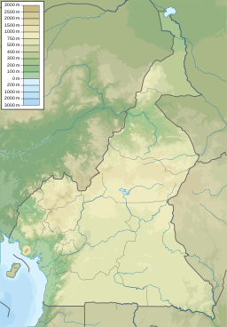
Lake Nyos is a crater lake in the Northwest Region of Cameroon, located about 315 km (196 mi) northwest of Yaoundé, the capital. Nyos is a deep lake high on the flank of an inactive volcano in the Oku volcanic plain along the Cameroon line of volcanic activity. A volcanic dam impounds the lake waters.

Oku is a subdivision in North West Region,, Cameroon. The term Oku also refers to the people who live in this region and the primary language that they speak. Oku is a rural area containing about 36 villages. The nearest really large city is Bamenda, but Kumbo, which is closer, is large enough to have telephone lines and a Baptist-run hospital. Oku also has a Sub-divisional hospital. However, three mobile telephone networks are available in Oku. As such, mobile internet facilities are available.

Kumba is a metropolitan city in the Meme department, Southwest Region, Western Cameroon, referred as "K-town" in local slang. Kumba is the most developed and largest city in the Meme Department and has attracted people from the local villages like Mbonge, Ekondo Titi, etc. Kumba has an estimated population of about 400,000 with three quarters of this population being youth. As a result of improvement in infant health care, rural-urban migration and infant mortality is falling while birthrates rise, causing the population of Kumba to increase. The N8 and N16 highways meet at Kumba.

The Cameroon line is a 1,600 km (990 mi) chain of volcanoes. It includes islands in the Gulf of Guinea and mountains that extend along the border region of eastern Nigeria and the West Region of Cameroon, from Mount Cameroon on the Gulf of Guinea north and east towards Lake Chad. The islands, which span the equator, have tropical climates and are home to many unique plant and bird species. The mainland mountain regions are much cooler than the surrounding lowlands, and also contain unique and ecologically important environments.

The Cameroonian Highlands forests, also known as the Cameroon Highlands forests, are a montane tropical moist broadleaf forest ecoregion located on the range of mountains that runs inland from the Gulf of Guinea and forms the border between Cameroon and Nigeria. This is an area of forest and grassland which has become more populous as land is cleared for agriculture.

The wildlife of Cameroon is composed of its flora and fauna. Bordering Nigeria, it is considered one of the wettest parts of Africa and records Africa's second highest concentration of biodiversity. To preserve its wildlife, Cameroon has more than 20 protected reserves comprising national parks, zoos, forest reserves and sanctuaries. The protected areas were first created in the northern region under the colonial administration in 1932; the first two reserves established were Mozogo Gokoro Reserve and the Bénoué Reserve, which was followed by the Waza Reserve on 24 March 1934. The coverage of reserves was initially about 4 percent of the country's area, rising to 12 percent; the administration proposes to cover 30 percent of the land area.
The Mount Oku hylomyscus is a species of rodent in the family Muridae. Found only on Mount Oku, Cameroon, in tropical Central Africa, its natural habitat is tropical moist montane forests. It has a very small range and is threatened by habitat destruction, so the International Union for Conservation of Nature has rated its conservation status as being "critically endangered".
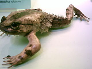
The hairy frog also known as the horror frog or Wolverine frog, is a Central African species of frog in the family Arthroleptidae. It is monotypic within the genus Trichobatrachus. Its common name refers to the somewhat hair-like structures on the body and thighs of the breeding male.
The Lake Oku clawed frog is a species of frog in the family Pipidae, endemic to Lake Oku, a small crater lake in northwest Cameroon. It is a small, dark-coloured, fully aquatic frog with a length of 28 to 36 mm, males being slightly smaller than females. The International Union for Conservation of Nature has rated this frog as "critically endangered" on the basis of its small area of occurrence at a single location, and the possibility that introduction of non-native fish into the lake could cause the frog to be wiped out.
Crotaphatrema lamottei, the Mount Oku caecilian or Lamotte's caecilian, is a species of caecilian in the family Scolecomorphidae. It is endemic to Mount Oku in Cameroon. The specific name lamottei honours Maxime Lamotte, French biologist. There is some doubt whether Crotaphatrema tchabalmbaboensis really is distinct from this species.

Lake Barombi Mbo or Barombi-ma-Mbu is a lake near Kumba in the Southwest Region of Cameroon. It is located in the Cameroon volcanic chain, and is the largest volcanic lake in this region. It is one of the oldest radiocarbon-dated lakes in Africa, with the youngest lava flow in it being about one million years old. On old colonial maps the area was known as Elefanten Sea, but the elephants living in the area were extirpated due to ivory trading.

The Oku Volcanic Field or Oku Massif is a group of volcanoes based on a swell in the Cameroon Volcanic Line, located in the Oku region of the Western High Plateau of Cameroon. The Mount Oku stratovolcano rises to 3,011 m above sea level.
Mount Oku, or Kilum Mountain, is the largest volcano in the Oku Massif, in the Cameroon Volcanic Line, located in the Oku region of the Western High Plateau of Cameroon. It is the second highest mountain in mainland Central Africa. The stratovolcano rises to 3,011 metres (9,879 ft) above sea level, and is cut by a large caldera.

The Rumpi Hills are an undulating mountain range with its highest peak, Mount Rata about 1,800 m (5,900 ft) located between the villages of Dikome Balue and Mofako Balue, Ndian division in the Southwest region of Cameroon. The hills are situated at 4°50’N 9°07’E, cutting across four local councils, with the eastern slopes in Dikome Balue, southern slopes in Ekondo Titi, western slopes in Mundemba, and northern slopes in Toko local councils respectively. These hills are located about 80 km (50 mi) north of Mount Cameroon; about 50 km (31 mi) west of the Bakossi Mountains and some 15 km (9.3 mi) southeast of the Korup National Park.
Lake Bermin is a small lake in the volcanic chain in the Southwest Region of Cameroon. It is a volcanic lake with a diameter of about 700 m (2,300 ft) and a crater rim that rises to a height of about 46 m (150 ft). This highly isolated lake is roughly circular in shape, lacks an inflow, but has an outflow into the Cross River system.
Lake Ejagham is a small lake near Eyumodjock in the Southwest Region of Cameroon. Unlike many other lakes in the region, it is not a volcanic lake, but is likely a solution basin formed by groundwater during the last Ice Age. This highly isolated lake is roughly oval in shape, lacks an inflow, but has an outflow into the Munaya River. The outflow is impassable to most fishes because of a waterfall.
Lake Barombi Koto, also known as Lake Barombi Kotto or Lake Barombi-ba-Kotto, is a small lake in the volcanic chain in the Southwest Region of Cameroon. It is a volcanic lake with a diameter of about 1.2 km (0.75 mi). There is a small island in the middle, which is densely inhabited by the Barombi, a tribe of fishers. The Tung Nsuia and Tung Nsuria streams, each about 1–2 m wide and 0.3 m deep near their mouth, are the only inflows into the lake, and they dry out in dry season.
Lake Dissoni, also known as Lake Soden, is a small lake in the volcanic chain in the Southwest Region of Cameroon. This volcanic lake has diameter of about 1.25 km (0.78 mi) and is at the southeastern foot of the Rumpi Hills.

A volcanic crater lake is a lake in a crater that was formed by explosive activity or a collapse during a volcanic eruption.
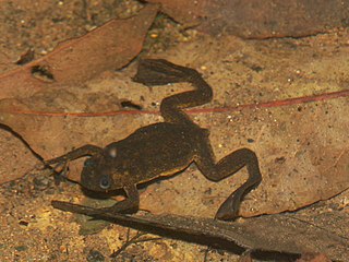
Phrynobatrachus chukuchuku, the spiny puddle frog, is a species of frog in the family Phrynobatrachidae. They are endemic to Cameroon, and considered Critically Endangered.