
Teak is a tropical hardwood tree species in the family Lamiaceae. It is a large, deciduous tree that occurs in mixed hardwood forests. Tectona grandis has small, fragrant white flowers arranged in dense clusters (panicles) at the end of the branches. These flowers contain both types of reproductive organs. The large, papery leaves of teak trees are often hairy on the lower surface. Teak wood has a leather-like smell when it is freshly milled and is particularly valued for its durability and water resistance. The wood is used for boat building, exterior construction, veneer, furniture, carving, turnings, and various small projects.

The Clocaenog Forest is in west Denbighshire and east Conwy, Wales on Mynydd Hiraethog. It takes its name from the village of Clocaenog, near Ruthin.

Urban forestry is the care and management of single trees and tree populations in urban settings for the purpose of improving the urban environment. Urban forestry involves both planning and management, including the programming of care and maintenance operations of the urban forest. Urban forestry advocates the role of trees as a critical part of the urban infrastructure. Urban foresters plant and maintain trees, support appropriate tree and forest preservation, conduct research and promote the many benefits trees provide. Urban forestry is practiced by municipal and commercial arborists, municipal and utility foresters, environmental policymakers, city planners, consultants, educators, researchers and community activists.
The Afan Forest Park is a 48-square-mile (120 km2) forest park in Britain. It is set in the Afan Valley in Neath Port Talbot, in south Wales. It is well known for its mountain biking and hiking or hillwalking trails. It is situated seven miles (11 km) from Junction 40 of the M4.
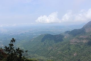
The Nilgiri Biosphere Reserve is a biosphere reserve in the Nilgiri Mountains of the Western Ghats in South India. It is the largest protected forest area in India, spreading across Tamil Nadu, Karnataka and Kerala. It includes the protected areas Mudumalai National Park, Mukurthi National Park, Sathyamangalam Wildlife Sanctuary in Tamil Nadu; Nagarhole National Park, Bandipur National Park, both in Karnataka; Silent Valley National Park, Aralam Wildlife Sanctuary, Wayanad Wildlife Sanctuary, and Karimpuzha Wildlife Sanctuary in Kerala.

Glen Affric is a glen south-west of the village of Cannich in the Highland region of Scotland, some 15 miles west of Loch Ness. The River Affric runs along its length, passing through Loch Affric and Loch Beinn a' Mheadhoin. A minor public road reaches as far as the end of Loch Beinn a' Mheadhoin, but beyond that point only rough tracks and footpaths continue along the glen.

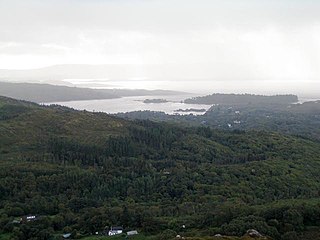
Glenmore Forest Park is a remnant of the Caledonian Forest near Aviemore in the Badenoch and Strathspey district of Highland, Scotland. Owned and managed by Forestry and Land Scotland, it lies within the Cairngorms National Park, and is one of six forest parks in the country. The forest park, which was established in 1948, covers 35.7 km2, of which 21.1 km2 is designated as a national nature reserve (NNR). Glenmore surrounds Loch Morlich, and is below the rise of the Cairngorms to the south; to the north the park extends to the summit of Meall a' Bhuachaille. The forest forms part of an expanse of Caledonian Forest that stretches from Glen Feshie to Abernethy, and which as a whole forms the largest single area of this habitat remaining in Scotland. It is home to much wildlife including Scottish crossbills, crested tits, capercaillie, narrow-headed ants, red squirrels and red deer.

Abernethy Forest is a remnant of the Caledonian Forest in Strathspey, in the Highland council area of Scotland. It lies within the Cairngorms National Park, close to the villages of Nethy Bridge, Boat of Garten, and Aviemore. The forest is an RSPB reserve, close to Loch Garten Osprey Centre, which is also owned by the RSPB. It is popular with walkers, as there are various trails throughout the reserve. The forest forms part of the wider Abernethy National Nature Reserve.

Bamse was a St. Bernard dog that became the heroic mascot of the Free Norwegian Forces during the Second World War. He became a symbol of Norwegian freedom during the war.

Bedford Purlieus is a 211-hectare (520-acre) ancient woodland in Cambridgeshire, in the United Kingdom. It is a national nature reserve and Site of Special Scientific Interest owned and managed by the Forestry Commission. In Thornhaugh civil parish, 10 km (6.2 mi) south of Stamford and 14 km (8.7 mi) west of Peterborough, the wood is within the Peterborough unitary authority area of Cambridgeshire, and borders Northamptonshire. In Roman times it was an iron smelting centre, during the medieval period it was in the Royal Forest of Rockingham, and later it became part of the estates of the Duke of Bedford. Bedford Purlieus appears to have been continuously wooded at least from Roman times, and probably since the ice receded. The woodland may have the richest range of vascular plants of any English lowland wood. It acquired particular significance in the 1970s as an early subject for the historical approach to ecology and woodland management.
Potton Wood covers an area of 85ha and is two miles east of the small town of Potton in the county of Bedfordshire, England. It is part of Ampthill Forest and is managed by Forest Enterprise and owned by the Forestry Commission.

Ganllwyd is a small village and community in southern Gwynedd, Wales. It lies in the Snowdonia National Park to the north of Dolgellau. A470 passes through it. The Community population taken at the 2011 Census was 179.

Lady Park Wood National Nature Reserve is a 45-hectare (110-acre) nature reserve straddling the borders of Gloucestershire in England and Monmouthshire in Wales. Most of the wood is in Wales – where it forms Wales' easternmost point – but it is managed under agreement with Natural England.
The United Kingdom, being in the British Isles, is ideal for tree growth, thanks to its mild winters, plentiful rainfall, fertile soil and hill-sheltered topography. In the absence of people, much of Great Britain would be covered with mature oaks, except for Scotland. Although conditions for forestry are good, trees do face damage threats arising from fungi, parasites and pests. The development of afforestation and the production and supply of timber in Wales come under Natural Resources Wales, as set out in the Forestry Act 1967.
Glengarriff Forest is an area of woodland near Glengarriff, West Cork, Ireland. Most of the woodland is a nature reserve in public ownership which is sometimes referred to as Glengarriff "forest park" or "state forest".

Ise Forest Reserve is located in Ekiti State, southwestern Nigeria, covering 142 km2, 5° 20.804'E to 5° 25.331'E longitude and 7°21.069'N to 7° 25.579'N latitude in the tropical hemisphere. The protected area is about 9 km to the southern part of the reserve along the Akure-Benin expressway from the Uso community in Ondo State. It remains one of the remaining forest fragments in southwest Nigeria, militated with intense human anthropogenic activities such as farming, logging, and hunting. However, they are considered to be integral and desirable components of forest ecosystems. It is one of the priority conservation areas for the endangered Nigeria-Cameroun chimpanzees in Nigeria with a degrading forest environment. The estimated terrain elevation above sea level is 366 meters. This is the chimpanzees' primary and most frequently recorded habitat in southwest Nigeria. It is also a habitat for about 661 species of butterflies and a large community of other animals and plants. It has been in the spotlight for nearly 20 years. One of the protected sites in the tropical hemisphere is the Ise Forest Reserve. Most of the forests in Nigeria, including protected areas, are under severe fragmentation. The result is that smaller fragments have fewer numbers of animals than the single larger fragments.

Scotland is ideal for tree growth, thanks to its mild winters, plentiful rainfall, fertile soil and hill-sheltered topography. As of 2019 about 18.5% of the country was wooded. Although this figure is well below the European Union (EU) average of 43%, it represents a significant increase compared to the figure of 100 years previously: in 1919 it was estimated that only 5% of the country's total land area was covered in forest. The Scottish Government's Draft Climate Change Plan has set an aim of increasing coverage to 21% of Scotland by 2032, with the rate of afforestation rising to 15,000 hectares per year by 2024.

Dyfnant Forest is a remote forest in northeastern-central Powys, Wales.

Glen Nant is a glen lying to the south of Taynuilt in the Argyll and Bute council area of Scotland. An area of woodland of 339 hectares on the western side of the River Nant is designated as national nature reserve (NNR), which is owned and managed by Forestry and Land Scotland (FLS). It is an example of an Atlantic Oakwood, and is one of largest areas of upland oak woodland in north Argyll.