Bamus Volcano is a volcano on New Britain near Ulawun. It last erupted in 1886. [1]

It is classified as a stratovolcano and noted to have a breached crater. [1]
Bamus Volcano is a volcano on New Britain near Ulawun. It last erupted in 1886. [1]

It is classified as a stratovolcano and noted to have a breached crater. [1]

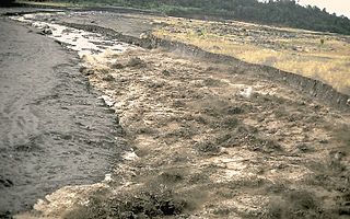
A lahar is a violent type of mudflow or debris flow composed of a slurry of pyroclastic material, rocky debris and water. The material flows down from a volcano, typically along a river valley.

Nevado del Ruiz, also known as La Mesa de Herveo is a volcano on the border of the departments of Caldas and Tolima in Colombia, about 129 km (80 mi) west of the capital city Bogotá. It is a stratovolcano composed of many layers of lava alternating with hardened volcanic ash and other pyroclastic rocks. Volcanic activity at Nevado del Ruiz began about two million years ago, since the Early Pleistocene or Late Pliocene, with three major eruptive periods. The current volcanic cone formed during the present eruptive period, which began 150,000 years ago.

Parícutin is a cinder cone volcano located in the Mexican state of Michoacán, near the city of Uruapan and about 322 kilometers (200 mi) west of Mexico City. The volcano surged suddenly from the cornfield of local farmer Dionisio Pulido in 1943, attracting both popular and scientific attention.

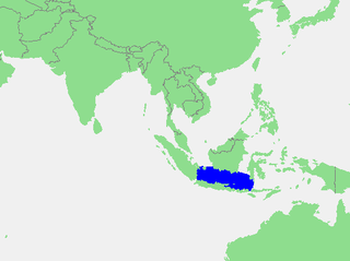
The Java Sea is an extensive shallow sea on the Sunda Shelf, between the Indonesian islands of Borneo to the north, Java to the south, Sumatra to the west, and Sulawesi to the east. Karimata Strait to its northwest links it to the South China Sea. It is a part of the western Pacific Ocean.

Arsia Mons is the southernmost of three volcanoes on the Tharsis bulge near the equator of the planet Mars. To its north is Pavonis Mons, and north of that is Ascraeus Mons. The tallest volcano in the Solar System, Olympus Mons, is to its northwest. Its name comes from a corresponding albedo feature on a map by Giovanni Schiaparelli, which he named in turn after the legendary Roman forest of Arsia Silva. Historically, it was known as Nodus Gordii before being renamed.
A volcano tectonic earthquake or volcano earthquake is caused by the movement of magma beneath the surface of the Earth. The movement results in pressure changes where the rock around the magma has experienced stress. At some point, this stress can cause the rock to break or move. This seismic activity is used by scientists to monitor volcanoes. The earthquakes may also be related to dike intrusion or occur as earthquake swarms.

Mount Takahe is a 3,460-metre-high (11,350 ft) snow-covered shield volcano in Marie Byrd Land, Antarctica, 200 kilometres (120 mi) from the Amundsen Sea. It is a c. 30-kilometre-wide (19 mi) mountain with parasitic vents and a caldera up to 8 kilometres (5 mi) wide. Most of the volcano is formed by trachytic lava flows, but hyaloclastite is also found. Snow, ice, and glaciers cover most of Mount Takahe. With a volume of 780 km3 (200 cu mi), it is a massive volcano; the parts of the edifice that are buried underneath the West Antarctic Ice Sheet are probably even larger. It is part of the West Antarctic Rift System along with eighteen other known volcanoes.

Barrington River, a perennial river of the Manning River catchment, is located in the Upper Hunter district of New South Wales, Australia.

Aguas Calientes Volcano or Cerro Aguas Calientes, also called Simba, is a cone-shaped stratovolcano located 5 kilometres (3 mi) east of the Lascar volcano and 10 kilometres (6.2 mi) north of Laguna Lejía, Chile. It is located within a 500 square kilometres (190 sq mi) area where the Cordón de Puntas Negras and the Cordón Chalviri volcanic chains intersect. The volcano is constructed from andesite and dacite containing hornblende and also anhydrite and its pyroclastics are all older than Lascar. It has a diameter of about 7 kilometres (4.3 mi). Some xenoliths of calc-alkaline material are found in Aguas Calientes lavas, and magma mixing has generated lavas containing andesite inclusions in dacites. One eruption of Aguas Calientes postdates the first centre of Lascar and was originally linked to the Lascar Piedras Grandes eruption, before sampling on the deposits of this eruption indicated a relationship with the Lascar volcano itself. Effusion of lava ceased after the cone was built. One summit lava flow may be of Holocene age, but no evidence of historical activity is found.

The Schouten Islands are a group of six small volcanic islands in the province of East Sepik in Papua New Guinea, north of the island of New Guinea. The group is also called Eastern Schouten Islands or Le Maire Islands to separate it from unrelated Schouten Islands in Indonesia. The combined land area is approximately 50 km2 (19 sq mi).
Nifiloli is an island in the Reef Islands, in the Solomon Islands province of Temotu. The estimated terrain elevation above sea level is 19 metres. Despite its location in Melanesia, the population of the islands is Polynesian.
Wangat River, a perennial river of the Hunter River catchment, is located in the Hunter region of New South Wales, Australia.

Bagabag is an island in the Madang Province of Papua New Guinea having a dormant volcano.
Gamble Cone is a cone 0.6 nautical miles (1.1 km) south-southeast of Post Office Hill in the Kyle Hills of Ross Island. The feature rises to about 400 metres (1,300 ft). At the suggestion of P.R. Kyle, it was named by the Advisory Committee on Antarctic Names (2000) after John A. Gamble, a geologist at the Victoria University of Wellington, New Zealand, who participated in three United States Antarctic Program field projects under Kyle's leadership, 1981–82, 1982–83, and 1984–85. He later worked with the New Zealand Antarctic Programme on the West Antarctic Volcano Exploration, 1989–90, a collaborative US–UK–NZ effort in Marie Byrd Land, and did extensive work on xenoliths that occur in volcanic rocks, including work at Cape Crozier and Cape Bird on Ross Island.
The Murgon fossil site is a paleontological site of early Eocene age in south-eastern Queensland, Australia. It lies near the town of Murgon, some 270 km north-west of Brisbane. The Murgon site is important as the only site on the continent with a diverse range of vertebrate fossils dating from the early Paleogene Period, making it a crucial period in mammal evolution. It is also important in demonstrating Australia's Gondwanan links with South America in the form of similar fossils from the two continents.

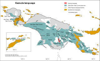
Kamula is a Trans–New Guinea language that is unclassified within that family in the classification of Malcolm Ross (2005). Noting insufficient evidence, Pawley and Hammarström (2018) leave it as unclassified.

Tabo, also known as Waia (Waya), is a Papuan language of Western Province, Papua New Guinea, just north of the Fly River delta. The language has also been known as Hiwi and Hibaradai.
Bamu, or Bamu Kiwai, is a Papuan language of southern Papua New Guinea.

Arago hotspot is a hotspot in the Pacific Ocean, presently located below the Arago seamount close to the island of Rurutu, French Polynesia.
The Bamu River is a river in southwestern Papua New Guinea.
5°12′S151°14′E / 5.200°S 151.233°E