
The Dogon are an ethnic group indigenous to the central plateau region of Mali, in West Africa, south of the Niger bend, near the city of Bandiagara, and in Burkina Faso. The population numbers between 400,000 and 800,000. They speak the Dogon languages, which are considered to constitute an independent branch of the Niger–Congo language family, meaning that they are not closely related to any other languages.

Mopti is the fifth administrative region of Mali, covering 79,017 km2. Its capital is the city of Mopti. During the 2012 Northern Mali conflict, the frontier between Southern Mali which is controlled by the central government and the rebel-held North ran through Mopti Region.

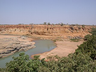
The Bandiagara Escarpment is an escarpment in the Dogon country of Mali. The sandstone cliff rises about 500 m (1,600 ft) above the lower sandy flats to the south. It has a length of approximately 150 km (90 mi).
Mali is a multilingual country. The languages spoken there reflect ancient settlement patterns, migrations, and its long history. Ethnologue counts more than 80 languages. Of these, French is the official language and Bambara is the most widely spoken. All together 13 of the indigenous languages of Mali have the legal status of national language.

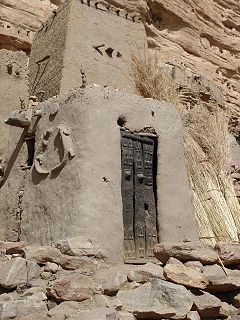
The Tellem were the people who inhabited the Bandiagara Escarpment in Mali between the 11th and 16th centuries CE. The Dogon people migrated to the escarpment region around the 14th century. In the rock cells of this red cliff, clay constructions shelter the bones of the Tellem as well as vestiges witnessing their civilization, well before that of the Dogons.
The wildlife of Mali, composed of its flora and fauna, is widely varying from the Saharan desert zone to the Sahelian east–west zone, to Mali, a landlocked francophone country in North Africa; large swathes of Mali remain unpopulated but has three sub-equal vegetation zones; the country has Sahara Desert in the north, the Niger River Basin at its center and the Senegal River on the south.
Religion in Mali is predominantly Islam with an estimated 95 percent of the population are Muslim, with the remaining 5 percent of Malians adhere to traditional African religions such as the Dogon religion, or Christianity. Atheism and agnosticism are believed to be rare among Malians, most of whom practice their religion daily, although some are Deist.

Sangha is a rural commune in the Cercle of Bandigara in the Mopti Region of Mali. The commune contains around 44 small villages and in the 2009 census had a population of 32,513. The administrative centre (chef-lieu) is the village of Sangha Ogol Leye, one of a cluster of at least 10 small villages at the top of the Bandiagara Escarpment.
Yoro is a village and commune and seat of the Cercle of Koro in the Mopti Region of Mali. In 1998 the commune had a population of 10,535. The village and Gangafani were attacked by suspected Fulani gunmen, who killed 41 people according to a MINUSMA count.
Youdiou (Yú:jú) is a village and commune and seat of the Cercle of Koro in the Mopti Region of Mali. In 1998 the commune had a population of 14,737.

Dogon country is a region of eastern Mali and northwestern Burkina Faso populated mainly by the Dogon people, a diverse ethnic group in West Africa with diverse languages. Like the term Serer country occupied by the Serer ethnic group, Dogon country is very vast, and lies southwest of the Niger River belt. The region is composed of three zones: the plateau, the escarpment and the Seno-Gondo plain.
Budu Dogon or Bunoge, also known as Korandabo, is a recently discovered Dogon language spoken in Mali. It was first reported online. The plural suffix on nouns is closest to Kolum so, suggesting it should be classified as a West Dogon language.
Bankan Tey Dogon, at first called Walo-Kumbe Dogon after the two main villages it is spoken in, also known as Walo and Walonkore, is a divergent, recently described Dogon language spoken in Mali. It was first reported online by Roger Blench, who reports that it is "clearly related to Nanga", which is only known from one report from 1953.
The Dogon dialects of the western plains below the Bandiagara Escarpment is Mali are mutually intelligible. They are sometimes called the Kan Dogon because they use the word kan for varieties of speech. The dialects are:
Ounjougou is the name of a lieu-dit found in the middle of an important complex of archaeological sites in the Upper Yamé Valley on the Bandiagara Plateau, in Dogon Country, Mali. The Ounjougou archaeological complex consists of over a hundred sites. The analysis of many layers rich in archaeological and botanical remains has enabled establishment of a major chronological, cultural and environmental sequence crucial to understand settlement patterns in the Inland Niger Delta and West Africa. Ounjougou has yielded the earliest pottery found in Africa, and is believed to be one of the earliest regions in which the independent development of pottery occurred.
On 10 June 2019, the Dogon village of Sobane Da in Mali was attacked. Moulaye Guindo, mayor of neighbouring Bankass, blamed a Fulani militia group. The attack killed 35 people, revised from an earlier claim of 95 killed with 19 missing. A survivor said the attackers numbered about 50, driving motorbikes and pickup trucks. The government of Mali has suspected that terrorists have committed the attack.
Youga Dogorou is one of the Dogon villages in Mali. It is one of the Youga group of villages, the others being Youga Piri and Youga Na. The village is about 12km northeast of Banani.
The Lebe or Lewe is a Dogon religious, secret institution and primordial ancestor, who arose from a serpent. According to Dogon cosmogony, Lebe is the reincarnation of the first Dogon ancestor who, resurrected in the form of a snake, guided the Dogons from the Mandé to the cliff of Bandiagara where they are found today.
The Binou is a Dogon totemic, religious order and secret ceremonial practice which venerates the immortal ancestors. It can also mean a water serpent or protector of a family or clan in Dogon. It is one of the four tenets of Dogon religion—an African spirituality among the Dogon people of Mali. Although the Dogons' "Society of the Masks" is more well known, due in part to Dogon mask–dance culture which attracts huge tourism, it is only one aspect of Dogon religion, which apart from the worship of the Creator God Amma, a rather distant and abstract deity in the Dogon world-view, is above all made up of ancestor veneration. The Binou serves as one of the four aspects of Dogon religion's ancestor veneration. Other than the Binou and the worship of Amma, the other three aspects of the religion includes the veneration of Lebe, which pertains to an immortal ancestor (Lebe) who suffered a temporary death in Dogon primordial time but was resurrected by the Nommo; the veneration of souls; and lastly, the Society of the Masks, which relates to dead ancestors in general. These myths are in oral form—known to us in a secret language. They form the framework of Dogon's religious knowledge, and are the fixed Dogon's sources relating to the creation of the universe; the invention of fire, speech and culture.

Tireli is a village in Dogon country in Mali on the Bandiagara Escarpment in the Bandiagara Cercle. It is located 11 km south-south-west of Sangha and Banani and 28 km east of Bandiagara.

