Bang Khun Thian subdistrict

Last updated • 2 min readFrom Wikipedia, The Free Encyclopedia
Bang Khun Thian
บางขุนเทียน
wadaekwaiphthuury ekhtcch`mth`ng krungethphmhaankhr (4).jpg
Chedi of Wat Kaeo Phaithun, formerly known as Wat Bang Prathun Nai the local historic temple
Khwaeng 103501.png
Location in Chom Thong District
CountryFlag of Thailand.svg  Thailand
Province Bangkok
Khet Chom Thong
Area
[1]
  Total5.789 km2 (2.235 sq mi)
Population
 (2020)
  Total35,779
Time zone UTC+7 (ICT)
Postal code
10150
TIS 1099 103501

Bang Khun Thian (Thai : บางขุนเทียน, pronounced [bāːŋkʰǔntʰīa̯n] ) is a khwaeng (sub-district) of Chom Thong district, Bangkok.

Contents

History

Bang Khun Thian is a name after a Khlong Bang Khun Thian, a khlong (canal) flows through the area.

The name "Bang Khun Thian" is not clear where it came from. Possibly distorted from the word Bang Khun Thiam or Bang Khun Kwian, because it was the resting place of the kwian (wagon) of a traveler or caravan. It is also proposed that the name comes from the name of a nobleman Khun Thian (ขุนเทียน), who played a role in overseeing the area and vicinity. [2]

In the past, Bang Khun Thian had a wide area extending to the Bangkok Bay (upper Gulf of Thailand) in the present Bang Khun Thian area. But from the new zoning of Bangkok Metropolitan Administration (BMA) in the year 1989, Chom Thong area has become a full district and Bang Khun Thian became part of this newly established district. [3]

Wat Sai floating market used to be in the area of Wat Sai rim Klong Dan or Khlong Sanam Chai used to be a very popular and famous floating market in the 1960s, when it was promoted as a tourist destination by Field Marshal Sarit Thanarat government, but has now closed completely. [4]

Geography

Bang Khun Thian is regarded as the northwest part of the district, with a total area of 5.789 km2 (2.235 mi2). [5]

The area is bounded by other sub-districts (from north clockwise): Bang Wa in Phasi Charoen District, Bang Kho in its district (Khlong Bang Prathun, Khlong Ta Cham, Khlong Rang Bua, Khlong Suan Luang Tai, Khlong Bang Wa are the borderlines), Chom Thong in its district (Khlong Sanam Chai is a borderline), Chom Thong in its district, Samae Dam in Bang Khun Thian District (Khlong Sanam Chai and Khlong Wat Sing are the borderlines), Khlong Bang Phran in Bang Bon District, Bang Wa in Phasi Charoen District (Khlong Wat Sing and Khlong Bang Ranae are the borderlines). [6]

Population

In 2018 it had a population of 36,479 people. [7]

Transportation

Wutthakat and Ekkachai Roads are the main routes of the sub-district.

Bang Khun Thian can also be reached by train via the Maeklong Railway that passes through the area.

While the canals that cross through the area can still serve as a thoroughfare as in the past. [3]

Related Research Articles

<span class="mw-page-title-main">Chom Thong district, Bangkok</span> Khet in Bangkok, Thailand

Chom Thong is one of the 50 districts (khet) of Bangkok, Thailand. The district is bounded by the districts Phasi Charoen, Thon Buri, Rat Burana, Thung Khru, Bang Khun Thian, and Bang Bon.

<span class="mw-page-title-main">Bang Khun Thian district</span> Khet in Bangkok, Thailand

Bang Khun Thian is one of the 50 districts (khet) of Bangkok, Thailand. Its neighbors, clockwise from the north, are Bang Bon, Chom Thong, and Thung Khru Districts of Bangkok, Phra Samut Chedi district of Samut Prakan province and Mueang Samut Sakhon district of Samut Sakhon province. Bang Khun Thian is Bangkok's southernmost district, and the only one bordering the Bay of Bangkok.

<span class="mw-page-title-main">Phahonyothin Road</span> Road in Thailand

Phahonyothin Road or Highway 1 is a main road in Bangkok and one of the four primary highways in Thailand, which include Mittraphap Road, Sukhumvit Road, and Phet Kasem Road. It begins at Victory Monument in Bangkok and runs north to the Burmese border, with a total length of 1,005 km (624 mi).

<span class="mw-page-title-main">Khlong Phasi Charoen</span>

Khlong Phasi Charoen is a canal west of the Chao Phraya River in the Thonburi area of the Bangkok conurbation. The canal links the Tha Chin River to Khlong Bangkok Yai. It starts at Khlong Bangkok Yai near Wat Paknam Bhasicharoen, Bangkok and ends south of Wat Ang Thong, Tambon Don Kai Di, Krathum Baen District, Samut Sakhon Province. It is approximately 24 km (14.9 mi) long.

<span class="mw-page-title-main">Ban Chang Lo</span> Khwaeng in Thailand

Ban Chang Lo is one of five subdistricts (khwaeng) and namesake historic neighbourhood in Bangkok Noi District, Bangkok's Thonburi side.

<span class="mw-page-title-main">Wat Nang Chi Chotikaram</span> Buddhist temple in Bangkok, Thailand

Wat Nang Chi Chotikaram or Wat Nang Chi Worawihan (วัดนางชีวรวิหาร), simply known as Wat Nang Chai (วัดนางชี) is a Thai Buddhist third-class royal temple in Bangkok.

<span class="mw-page-title-main">Bang Phrom subdistrict, Bangkok</span> Khwaeng in Thailand

Bang Phrom is a khwaeng (subdistrict) of Taling Chan district, Bangkok's Thonburi side.

<span class="mw-page-title-main">Khlong Sanam Chai</span> Canal connecting Bangkok and Samut Sakhon, Thailand

Khlong Sanam Chai and Khlong Mahachai are names of a khlong (canal) in Thailand, which links the Chao Phraya River in Bangkok's Thonburi side to the Tha Chin River river in Samut Sakhon Province.

<span class="mw-page-title-main">Samae Dam</span> Sub-district in Bangkok, Thailand

Samae Dam is a khwaeng (sub-district) of Bang Khun Thian District, Bangkok.

<span class="mw-page-title-main">Tha Kham, Bangkok</span> Khwaeng in Thailand

Tha Kham is a khwaeng (subdistrict) in Bang Khun Thian District, Bangkok.

<span class="mw-page-title-main">Bang Khae Nuea</span> Khwaeng in Thailand

Bang Khae Nuea is a khwaeng (sub-district) of Bang Khae District, Bangkok.

<span class="mw-page-title-main">Khuha Sawan, Bangkok</span> Khwaeng in Thailand

Khuha Sawan is a khwaeng (subdistrict) of Phasi Charoen District, in Bangkok, Thailand. In 2020, it had a total population of 6,063 people.

<span class="mw-page-title-main">Chomphon subdistrict</span> Khwaeng in Thailand

Chomphon, also spelled Chom Phon, is a khwaeng (subdistrict) of Chatuchak District, Bangkok, Thailand.

<span class="mw-page-title-main">Wat Sam Phraya subdistrict</span> Khwaeng in Thailand

Wat Sam Phraya is a khwaeng (subdistrict) in Phra Nakhon District, Bangkok.

<span class="mw-page-title-main">Khlong Bang Bon subdistrict</span> Khwaeng in Thailand

Khlong Bang Bon is a khwaeng (subdistrict) of Bang Bon District in southwest Bangkok.

<span class="mw-page-title-main">Talat Phlu subdistrict</span> Khwaeng in Thailand

Talat Phlu is a khwaeng (sub-district) in Thon Buri district, Bangkok. It encompasses a historic district and a bustling day and night marketplace known as Talat Phlu.

<span class="mw-page-title-main">Wat Ratchaorasaram</span>

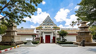
Wat Ratchaorasaram Ratchaworawihan, often called shortened to Wat Ratchaorot (วัดราชโอรส) is an ancient Thai Buddhist temple in Bangkok.

<span class="mw-page-title-main">Wat Nang Ratchaworawihan</span>

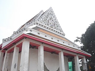
Wat Nang Ratchaworawihan, usually shortened to Wat Nang (วัดหนัง) is classified as the third class abbey in royal temple within Ratchaworawihan classification.

<span class="mw-page-title-main">Min Buri subdistrict</span> Khwaeng in Thailand

Min Buri is a khwaeng (subdistrict) of Min Buri district, Bangkok, Thailand.

<span class="mw-page-title-main">Lat Phrao subdistrict</span> Khwaeng in Thailand

Lat Phrao is a khwaeng (subdistrict) of Lat Phrao district, Bangkok.

References

  1. Administrative Strategy Division, Strategy and Evaluation Department, Bangkok Metropolitan Administration (2021). สถิติกรุงเทพมหานครประจำปี 2563 [Bangkok Statistics 2020](PDF) (in Thai). Retrieved 27 November 2021.{{cite web}}: CS1 maint: multiple names: authors list (link)
  2. Bangkok Metropolitan Cultural Council (2015-06-15). "ประวัติความเป็นมาชื่อเขต "บางขุนเทียน"" [History of the name of the district "Bang Khun Thian"]. Facebook (in Thai).
  3. 1 2 Wongtes, Sujit; Boonpan, Khanchai (2018). ย่านข้าหลวงเดิม บางขุนเทียน: เส้นทางคลองประวัติศาสตร์ ฝั่งทะเลทวารวดี กรุงเทพฯ[The old nobles quarter Bang Khun Thian: The historic canal route Dvaravati seaside, Bangkok] (in Thai). Matichon.
  4. Sor.Sot (2018-09-06). "ตำนานตลาดน้ำวัดไทร" [Legend of Wat Sai floating market]. Posttoday (in Thai).
  5. กองนโยบายและแผนงาน. สำนักผังเมือง. กรุงเทพมหานคร. ประชากรกรุงเทพมหานครและปริมณฑล พ.ศ. 2549. Archived 2020-06-24 at the Wayback Machine Thai : Thai
  6. "ประกาศกรุงเทพมหานคร เรื่อง พื้นที่แขวงบางขุนเทียน แขวงบางค้อ แขวงบางมด และเปลี่ยนแปลงพื้นที่แขวงจอมทอง เขตจอมทอง" (PDF). ราชกิจจานุเบกษา (in Thai). 114 (พิเศษ 121 ง): 110–117. 1997-12-24. Archived from the original (PDF) on March 4, 2016.
  7. กรมการปกครอง. กระทรวงมหาดไทย. "รายงานสถิติจำนวนประชากรและบ้าน ประจำปี พ.ศ. 2561." [ออนไลน์]. เข้าถึงได้จาก: http://stat.dopa.go.th/stat/statnew/statTDD/views/showZoneData.php?rcode=1035&statType=1&year=61 2562. สืบค้น 15 สิงหาคม 2562. Thai : Thai

13°41′48″N100°27′26″E / 13.6967°N 100.4572°E / 13.6967; 100.4572