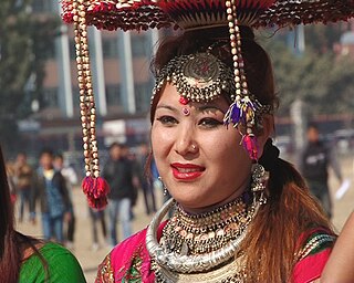
The Tharu people are an ethnic group indigenous to the Terai in southern Nepal and northern India. They are recognized as an official nationality by the Government of Nepal.

Gorakhpur is a city in the Indian state of Uttar Pradesh, along the banks of the Rapti river in the Purvanchal region. It is situated 270 kilometres east of the state capital Lucknow. It is the administrative headquarters of Gorakhpur district, North Eastern Railway Zone and Gorakhpur division. The city is home to the Gorakhnath Math, a Gorakhnath temple. The city also has an Indian Air Force station, since 1963. Gita Press, the world's largest publisher of Hindu religious texts is also located in Gorakhpur.

The Shri Gorakhnath Mandir is a temple of the Nath monastic order group of the Nath tradition. The name Gorakhnath derives from the medieval saint, Gorakshanath, a yogi who travelled widely across India and authored a number of texts that form a part of the canon of Nath Sampradaya. The Nath tradition was founded by guru Matsyendranath. This math is situated in Gorakhpur, Uttar Pradesh, India within large premises. The temple performs various cultural and social activities and serves as the cultural hub of the city.

Ballia is a city with a municipal board in the Indian state of Uttar Pradesh. The eastern boundary of the city lies at the junction of two major rivers, the Ganges and the Ghaghara.The city is situated 140 km (87 mi) east of Varanasi and about 380 km from the state capital Lucknow. It has a plant sanctuary protected area, the Jai Prakash Narayan bird sanctuary.

Maharajganj district is one of the 75 districts of Uttar Pradesh state in northern India, and the town of Maharajganj is the district headquarter. District is a part Gorakhpur division. It is located in Terai regions of Himalayas, bordering Nepal in North.

Kapilvastu district, often Kapilbastu, is one of the districts of Lumbini Province, Nepal. The district, with Kapilbastu municipality as its district headquarters, covers an area of 1,738 square kilometres (671 sq mi) and in 2001 had a population of 481,976, which increased to 571,936 in 2011. Kapilvastu district has 3 number of seats for central whereas 6 seats for state level elections.
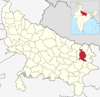
Gorakhpur district is a district of Uttar Pradesh in India. Gorakhpur is the administrative headquarters of the district.
Bansi is a town and a municipal board in Siddharthnagar district in the state of Uttar Pradesh, India Bansi is situated on the bank of Rapti River in Siddharthnagar District.
Barhalganj (बड़हलगंज) is a town in the municipality of Gorakhpur, Uttar Pradesh. The town is surrounded by several rivers, which are of religious significance to the Hindu population in Uttar Pradesh. Barhalganj is situated on the left bank of the Ghaghra river, a tributary of the Ganges, and the town is connected to the district of Mau by a bridge over the Saryu river.
Nautanwa is a town and Nagar Palika in Maharajganj district in the state of Uttar Pradesh, India. It is about 87 km from Gorakhpur, NH24 and 68 km NH730 from Maharajganj and 7 km from Sonauli Indo-Nepal Border.
Pharenda, or Anandnagar, is a city in the Maharajganj district of the province of Uttar Pradesh in northern India. It is located approximately 44 kilometres north of Gorakhpur near the border with Nepal. District of Pharenda is Maharajganj. This is situated on the Buddhist Circuit which is built from Sarnath to Lumbini. It lies on NH-24 and near NH 29. It is about 45 km from Gorakhpur, 40 km from Siddharthnagar, 30 km from Maharajganj and 55 km from Sonauli Indo-Nepal Border. This place is named after Seth Anandram Jaypuriya. There is closed sugar Mill which was started in about 1935 and closed in 1995. Near Anand Nagar there is a temple is Durga devi mandir, popularly known as Lehara Devi mandir.
Padrauna is a city and district headquarter of Kushinagar in the Indian state of Uttar Pradesh. Its ancient name was Pava where Buddha took his last meal. It is the place where Rama spent a few days of his life. After passing from Padrauna, Rama reached at Ramkola where he made a hut with his wife Sita and younger brother Lakshman to stay. Padrauna is also the place of ancient Malla Kshatriyas who were following a democratic form of government from their Santhagara. It is situated 21 kilometers east of Kushinagar town.
Madheshi people is a term used for several groups of people living in the Terai region of Nepal, literally meaning the people of Madhesh. It has also been used as a political pejorative term by the Pahari people of Nepal to refer to non-pahari people with a non-Nepali language as their mother tongue, regardless of their place of birth or residence. The term Madheshi became a widely recognised name for Nepali citizens with an Indian cultural background only after 1990. Madheshi people comprise various cultural groups such as Hindu caste groups, Muslims, Marwaris, Brahmin and Dalit caste groups, ethnic groups like Maithils, Bhojpuri, Awadhi and Bajjika speaking people and indigenous people of the Terai. Many of these groups share cultural traditions, educational and family ties with people living south of the international border in Bihar, Uttar Pradesh and West Bengal. Tharu people and Pahari people living in the Terai do not consider themselves as Madheshi. In recent times, some politicians and journalists use the term for all Nepali citizens of the Terai.
Hardauna is a village in the sub-metropolitan municipality of Maharajganj in the Kapilvastu District of the Lumbini Province. The village is in a terai region in southern Nepal. It is on the Banganga, a river which arises on the southern slopes of the Sivalik Hills and flows across the terai, reaching into Uttar Pradesh state in India.
West Rapti drains Rapti Zone in Mid-Western Region, Nepal, then Awadh and Purvanchal regions of Uttar Pradesh state, India before joining the Ghaghara—a major left bank tributary of the Ganges known as the Karnali inside Nepal.
The Rauniyar is a Hindu caste mostly found in India and Nepal. They are also known as Rauniyar, Roniyar and Roniaur, they use Rauniyar, Gupta, Sah, Shah, Keshri, Ranjan as their surnames.
Belwania is a small village situated between Padrauna and Chhitauni on the National Highway 28B in the Kushinagar District of Uttar Pradesh State in India. It is under the Gram Panchayat of Dargauli and the current Gram Pradhan of the Dargauli Gram Panchayat is Mr. Phul Badan 'Saroj'. The village is situated almost on the border of Uttar Pradesh and Bihar.
Khajuriya Sarki is a village near Dhebarua in Shoratgarh Assembly Constituency of Siddharthnagar District, Uttar Pradesh state, India. The village has a nearby railway station Barhni on the Gorakhpur–Gonda Indian Railways. It is 6 km from the Nepal border Krishnanagar (JhandeNagar)
Siddharthnagar also known as Naugarh is a city and the district headquarters of Siddharthnagar in Uttar Pradesh, India. It is one of the five Vidhan Sabha constituencies in Siddharthnagar district, though the constituency has been renamed to Kapilvastu. It is a town located near Lumbini, the birthplace of Gautam Buddha. Lumbini is the best place to visit from Siddharthnagar, It is situated north from Siddharthnagar railway station at the distance of 20 Kilometer.
Shyam Dhani is an Indian politician and a member of 17th Legislative Assembly of Uttar Pradesh of India. He represents the Kapilvastu constituency in Siddharthnagar district of Uttar Pradesh and is a member of the Bharatiya Janata Party.
