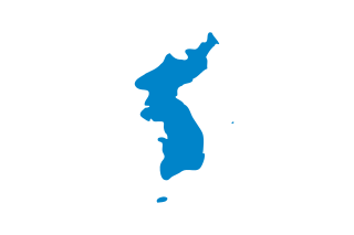
Korea is a peninsular region in East Asia. Since 1945, it has been divided at or near the 38th parallel, now known as the Korean Demilitarized Zone. In 1948, two states declared independence, both claiming sovereignty over all of Korea: South Korea comprising its southern half and North Korea comprising its northern half. The region consists of the Korean Peninsula, Jeju Island, and a number of minor islands near the peninsula. The peninsula is bordered by China (Manchuria) to the north and Russia to the northeast, across the Amnok and Duman rivers. It is separated from Japan to the southeast by the Korea Strait.

North Korea is located in East Asia in the Northern half of Korea, partially on the Korean Peninsula. It borders three countries: China along the Yalu (Amnok) River, Russia along the Tumen River, and South Korea to the south.

The Yalu River or Amnok River is a river on the border between China and North Korea. Together with the Tumen River to its east, and a small portion of Paektu Mountain, the Yalu forms the border between China and North Korea. Its valley became the scene of several military conflicts in the past centuries.

Paektu Mountain or Baekdu Mountain (Korean: 백두산) is an active stratovolcano on the Chinese–North Korean border. In China, it is known as Changbai Mountain. At 2,750 m (9,022 ft), it is the tallest mountain in North Korea and Northeast China and the tallest mountain of the Baekdu-daegan and Changbai mountain ranges. The highest peak, called Janggun Peak, belongs to North Korea. The mountain notably has a caldera that contains a large crater lake called Heaven Lake, and is also the source of the Songhua, Tumen, and Yalu rivers. Korean and Manchu people assign a mythical quality to the mountain and its lake, and consider the mountain to be their ancestral homeland.
Buddhist temples are an important part of the Korean landscape. Most Korean temples have names ending in -sa, which means "monastery" in Sino-Korean. Many temples participate in the Templestay program, where visitors can experience Buddhist culture and even stay at the temple overnight.

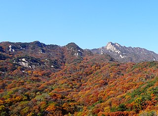
Chungju (충주시) is a city in North Chungcheong province, South Korea. Uamsan is a mountain located within the outskirts of the city.

Yeoju is a city in Gyeonggi Province, South Korea. Yeoju was a county but was raised to the status of a city in September 2013. Together with the neighboring city of Icheon, it is known as a major center of contemporary South Korean ceramics, and hosts the World Ceramic Exposition every year. Other local products of note include rice, sweet potatoes, and yellow melons. Yeoju is the birthplace of Korea's last queen, Empress Myeongseong.
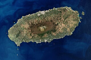
Jeju Island is South Korea's largest island, covering an area of 1,833.2 km2 (707.8 sq mi), which is 1.83 percent of the total area of the country. Alongside outlying islands, it is part of Jeju Province.

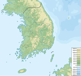
Korea comprises the Korean Peninsula and 3,960 nearby islands. The peninsula is located in Northeast Asia, between China and Japan. To the northwest, the Amnok River separates Korea from China and to the northeast, the Duman River separates Korea from China and Russia. The Yellow Sea lies to the west, the East China Sea and Korea Strait to the south, and the Korean East Sea to the east. Notable islands include Jeju Island (Jejudo), Ulleung Island (Ulleungdo), and the Liancourt Rocks.
The Taego Order or Taego-jong is the second largest order in Korean Seon, the Korean branch of Chan Buddhism.

McFarland & Company, Inc., is an American independent book publisher based in Jefferson, North Carolina, that specializes in academic and reference works, as well as general-interest adult nonfiction. Its president is Rhonda Herman. Its former president and current editor-in-chief is Robert Franklin, who founded the company in 1979. McFarland employs a staff of about 50, and as of 2019 had published 7,800 titles. McFarland's initial print runs average 600 copies per book.
Cheonmasan (Korean: 천마산) is a mountain in Gyeonggi Province, South Korea. It can be found within the boundaries of the city of Namyangju. Cheonmasan has an elevation of 810.2 m (2,658 ft).
Cheonghwasan (Korean: 청화산) is a mountain between the county of Goesan, North Chungcheong Province and the city of Sangju, North Gyeongsang Province, South Korea. It has an elevation of 984 m (3,228 ft).

Eunsusa is a small Korean Buddhist temple that sits at the base of Sutmaibong (peak), or Elephant Rock, in the Maisan in Jinan County, North Jeolla Province, South Korea.

Taesŏngsan (Korean: 대성산) is a mountain in Taesong-guyok, Pyongyang, North Korea. It has an elevation of 270 metres (890 ft). One popular visitor attraction on Taesŏngsan is the outdoor ice rink. Others include the Revolutionary Martyrs' Cemetery and the Korea Central Zoo.

Jangsan is a mountain in Haeundae District, Busan, South Korea. It has an elevation of 634 metres.

Maisan (Korean: 마이산) is a mountain of Jeollabuk-do, western South Korea. It has an elevation of 686 metres.
Muryongsan is a mountain of Jeollabuk-do, western South Korea. It has an elevation of 1,492 metres (4,895 ft).
Bohyeonsan or Bohyeon Mountain or Mount Bohyeon is located in the province of Gyeongsangbuk-do, eastern South Korea. Its peak has an elevation of 1,121 metres (3,678 ft), and is near the city of Yeongcheon.

The Korean International School of Shenzhen is a South Korean international school that opened in 2005. KIS is located near the Nanshan Mountain, within the Shekou Industrial Zone, Nanshan District. KIS is a private international school with 300 students ranging from kindergarten to high school. However, KIS has only one campus, despite the large number of students. This figure has risen over time and continues to rise.