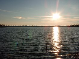
Lake Erie is the fourth-largest lake by surface area of the five Great Lakes in North America and the eleventh-largest globally. It is the southernmost, shallowest, and smallest by volume of the Great Lakes and also has the shortest average water residence time. At its deepest point, Lake Erie is 210 feet (64 m) deep, making it the only Great Lake whose deepest point is above sea level.

Lake Michigan is one of the five Great Lakes of North America. It is the second-largest of the Great Lakes by volume and depth after Lake Superior and the third-largest by surface area, after Lake Superior and Lake Huron. To the east, its basin is conjoined with that of Lake Huron through the wide and deep Straits of Mackinac, giving it the same surface elevation as its easterly counterpart; hydrologically, the two bodies are a single lake that is, by area, the largest freshwater lake in the world.

Lake County is a county located in the northeastern corner of the U.S. state of Illinois, along the shores of Lake Michigan. As of the 2020 census, it has a population of 714,342, making it the third-most populous county in Illinois. Its county seat is Waukegan, the tenth-largest city in Illinois. The county is primarily suburban, with some urban areas and some rural areas. Due to its location, immediately north of Cook County, Lake County is one of the collar counties of the Chicago metropolitan area. Its northern boundary is the Wisconsin state line.

Lakemoor is a village in Lake and McHenry counties in the U.S. state of Illinois. Per the 2020 census, the population was 6,182.

Wauconda is a village in Lake County, Illinois, United States, a northwest suburb of Chicago. Per the 2020 census, the population was 14,084. It is the site of the Wauconda Bog Nature Preserve, a National Natural Landmark. Wauconda Community Unit School District 118 serves students from Pre-K through 12th grade who live in Wauconda and surrounding communities. Fremont School District 79 also serves students from communities from northern part of Wauconda.

Waukegan is the most populous city in and county seat of Lake County, Illinois, United States. Located 36 miles (58 km) north of Chicago, Waukegan is a satellite city within the greater Chicagoland area. As of the 2020 census, its population was 89,321, making it the seventh-most populous city within the Chicago metropolitan area and the 10th-most populous city in Illinois.

Balatonfüred is a resort town in Veszprém county, in Hungary. The town with a population of 13,000 is situated on the northern shore of Lake Balaton. It is considered to be the capital of the Northern lake shore and is a yachting destination. It is also a location for fishing although the introduction of eels and other non-indigenous species has caused ecological damage in recent years.

Indiana Dunes National Park is a national park of the United States located in northwestern Indiana managed by the National Park Service. It was authorized by Congress in 1966 as the Indiana Dunes National Lakeshore and was redesignated as the nation's 61st national park on February 15, 2019. The park runs for about 20 miles (32 km) along the southern shore of Lake Michigan and covers 15,349 acres (6,212 ha). Along the lakefront, the eastern area is roughly the lake shore south to U.S. 12 or U.S. 20 between Michigan City, Indiana, on the east and the Cleveland-Cliffs steel plant on the west. This area's conservation scheme is enhanced by the older Indiana Dunes State Park. To the west of the steel plant lies West Beach and a small extension south of the steel mill continues west along Salt Creek to Indiana 249. The western area is roughly the shoreline south to U.S. 12 between the Burns Ditch west to Broadway in downtown Gary, Indiana. In addition, there are several outlying areas, including Pinhook Bog, in LaPorte County to the east; the Heron Rookery in Porter County, the center of the park; and the Hoosier Prairie State Nature Preserve and the Hobart Prairie Grove, both in Lake County, the western end of the park.

Bear Lake is a natural freshwater lake on the Idaho–Utah border in the Western United States. About 109 square miles (280 km2) in size, it is split about equally between the two states; its Utah portion comprises the second-largest natural freshwater lake in Utah, after Utah Lake. The lake has been called the "Caribbean of the Rockies" for its unique turquoise-blue color, which is due to the refraction of calcium carbonate (limestone) deposits suspended in the lake. Its water properties have led to the evolution of several unique species of fauna that occur only within the lake. Bear Lake is over 250,000 years old. It was formed by fault subsidence that continues today, slowly deepening the lake along the eastern side. In 1911 the majority of the flow of the Bear River was diverted into Bear Lake via Mud Lake and a canal from Stewart Dam, ending 11,000 years of separation between the lake and that river system.
Lake Attitash is a lake located on the border of Merrimac, Massachusetts and Amesbury, Massachusetts, and constitutes at least a portion of Amesbury's water supply.

Northern Michigan, also known as Northern Lower Michigan, is a region of the U.S. state of Michigan. A popular tourist destination, it is home to several small- to medium-sized cities, extensive state and national forests, lakes and rivers, and a large portion of Great Lakes shoreline. The region has a significant seasonal population much like other regions that depend on tourism as their main industry. Northern Lower Michigan is distinct from the more northerly Upper Peninsula and Isle Royale, which are also located in "northern" Michigan. In the northernmost 21 counties in the Lower Peninsula of Michigan, the total population of the region is 506,658 people.

Indian Lake, also known as North Pond, is a lake located in northern Worcester, Massachusetts. The most recent water quality report from 2023 indicated that "Water Clarity at Indian Lake. Between 6Jun and 5-Jul, Secchi depth readings were high compared to past results at Indian Lake ranging between 6.75 ft and 10.75 ft, indicating clearer water. From mid-July through September, readings ranged between 4.5 ft and 5.25 ft, closer to past observations for summertime in Indian Lake. Secchi depth was in the range considered “Poor” on two occasions late in the season 19-Sep (3.75 ft), and 17-Oct (2.75 ft). This late season drop in clarity is expected based on past program monitoring results. Figure 4 - Secchi depth was considered "fair" for most of the season with some values in the "good" and "fair" categories. Depths ranged from 2.75-10.75 feet. At both in-lake sites, surface TSS results ranged between 1.5 mg/L and 8.9 mg/L, remaining in the range considered “Excellent” during all sampling events. These results were comparable to those in years past. All but one bottom TSS result from the Northern Site fell below 10 mg/L. As expected, TSS increased as Secchi depth decreased at Indian Lake. L&P rates water clarity at Indian Lake as “Fair” in 2023." The mean and maximum depths are 8 and 15 feet respectively. The bottom is sand and rock. The shoreline is heavily developed with residential dwellings and commercial buildings.

Dug Pond is a small body of water in Natick, Massachusetts. Most notably it is home to Memorial Beach, one of few swimming beaches in Natick, and its eastern shore is the site of Natick High School.
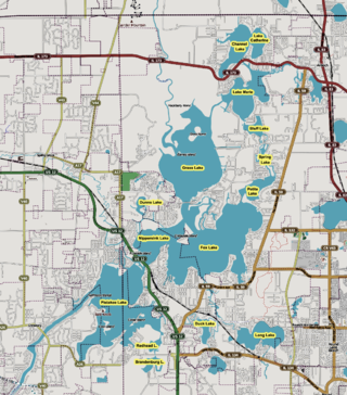
The Chain O'Lakes, or simply "The Chain", is a waterway system in northeast Illinois composed of 15 lakes connected by the Fox River and man-made channels. Encompassing more than 7,100 acres (29 km2) of water, 488 miles (785 km) of shoreline and 45 miles (72 km) of river, the Chain is the busiest inland recreational waterway per acre in the United States.

Crystal Lake is a 455-acre (1.8 km2) water body located in Belknap County in the Lakes Region of central New Hampshire, United States, in the town of Gilmanton. Crystal Lake is at the head of the Suncook River watershed. Water flows into Crystal Lake from the Belknap Range through Manning and Sunset lakes to the north. Water from Manning Lake enters Crystal Lake via Nelson Brook. Other waterways flowing into Crystal Lake include Wasson Brook and Mill Brook. Water flows out of a dam from the southern end of Crystal Lake via the Suncook Lakes and Suncook River to the Merrimack River. Shoreline development along Crystal Lake consists primarily of summer cottages, with a few year-round residents. Belknap Mountain and Mount Major can be seen from the shoreline.

Madge Lake is a freshwater lake located in eastern Saskatchewan, 18 km east of the town of Kamsack and just a few kilometres west of the province's eastern boundary. Road access to the lake is via Highway 57, which passes by the south shore of Madge Lake as it connects Highway 5 to Manitoba Highway 83.
Fishing Lake is a closed basin freshwater lake in the Canadian province of Saskatchewan. The lake is 22 kilometres (14 mi) north of the town of Foam Lake, and 24 kilometres (15 mi) east of the town of Wadena and is accessed from Highways 5 and 310. The northern and eastern shore is in the RM of Sasman No. 336 and the southern and western shore is in the RM of Foam Lake No. 276. The north-east portion of the lake–on the east side of McCormick Bay–is designated as Fishing Lake Wildlife Refuge.
Wooster Lake is a lake in Lake County, Illinois, United States. It is located near Illinois Route 134 and Wilson Road, predominantly in unincorporated Ingleside, northeast of the Village of Volo, northwest of the Village of Round Lake, and southeast of the Village of Fox Lake.
Echo Lake is a lake along the course of the Qu'Appelle River in the Canadian province of Saskatchewan. Echo Lake is so named because of the echo heard by the First Nations while paddling on the lake. It is one of four lakes that make up the Fishing Lakes. Pasqua Lake is upstream and Mission Lake is downstream. The lake can be accessed by Highway 56 and Highway 210. In 1942, a 4-metre (13 ft) high dam was built on the Qu'Appelle River at Echo Lake's outflow to control the lake's water levels. In the summer of 2024, Saskatchewan's Water Security Agency begun "interim repairs" on Echo Lake Dam to "improve safety and extend the dam's life until a replacement can be completed".