Related Research Articles

Transportation in Malawi is poorly developed. The country of almost 14 million has 39 airports, 6 with paved runways and 33 with unpaved runways. It has 797 kilometres of railways, all narrow-gauge and about 45 percent of its roads are paved. Though it is landlocked, Malawi also has 700 km (435 mi) of waterways on Lake Malawi and along the Shire River.

The British Central Africa Protectorate (BCA) was a British protectorate proclaimed in 1889 and ratified in 1891 that occupied the same area as present-day Malawi: it was renamed Nyasaland in 1907. British interest in the area arose from visits made by David Livingstone from 1858 onward during his exploration of the Zambezi area. This encouraged missionary activity that started in the 1860s, undertaken by the Universities' Mission to Central Africa, the Church of Scotland and the Free Church of Scotland, and which was followed by a small number of settlers. The Portuguese government attempted to claim much of the area in which the missionaries and settlers operated, but this was disputed by the British government. To forestall a Portuguese expedition claiming effective occupation, a protectorate was proclaimed, first over the south of this area, then over the whole of it in 1889. After negotiations with the Portuguese and German governments on its boundaries, the protectorate was formally ratified by the British government in May 1891.

Nsanje is the main city in Nsanje District within the Southern Region of Malawi.
The Shire is the largest river in Malawi. It is the only outlet of Lake Malawi and flows into the Zambezi River in Mozambique. Its length is 402 kilometres (250 mi). The upper Shire River issues from Lake Malawi and runs approximately 19 km (12 mi) before it enters shallow Lake Malombe. It then drains Lake Malombe and flows south through Liwonde National Park where large concentrations of hippopotamus are common along its shores. Between the towns of Matope and Chikwawa, the middle river drops approximately 400 m (1,300 ft) through a series of falls and gorges, including Kapachira Falls. Two hydroelectric dams have been built along the Shire northwest of Blantyre.
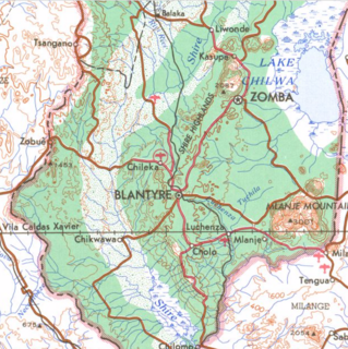
The Shire Highlands are a plateau in southern Malawi, located east of the Shire River. It is a major agricultural area and the most densely populated part of the country.

Nsanje is a district in the Southern Region of Malawi. The capital is Nsanje. The district covers an area of 1,942 square kilometres (750 sq mi) and has a population of 194,924.
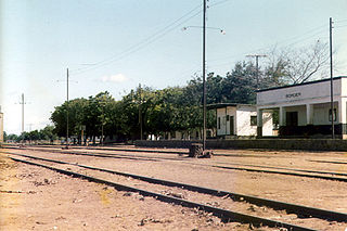
Malawi Railways was a government corporation that ran the national rail network of Malawi, Africa, until privatisation in 1999. With effect from 1 December 1999, the Central East African Railways consortium led by Railroad Development Corporation won the right to operate the network. This was the first rail privatisation in Africa which did not involve a parastatal operator.
The Kluskus First Nation is the band government of the Lhoosk’uz, a Dakelh people whose main reserve located on the Chilcotin Plateau 130 km west of the city of Quesnel, British Columbia, Canada. The First Nation is a member of the Carrier-Chilcotin Tribal Council, which includes both Tsilhqot'in and Carrier (Dakelh) communities.
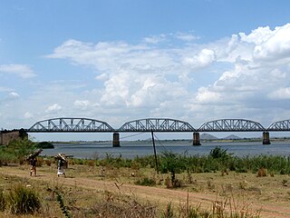
The Dona Ana Bridge spans the lower Zambezi River between the towns of Vila de Sena and Mutarara in Mozambique, effectively linking the two halves of the country. It was originally constructed as a railway bridge to link Malawi and the Moatize coal fields to the port of Beira.
Central East African Railways is a consortium formed in 1999, led by the Railroad Development Corporation, which won the right to operate the Malawi Railways network. The company was sold in September 2008 to INSITEC, an investment group based in Mozambique.
Malawi Railways is the national rail network in Malawi, run by a government corporation until privatisation in 1999. As of 1 December 1999 the Central East African Railways, a consortium led by Railroad Development Corporation, won the right to operate the network.
Moi's Bridge is a small town that has its roots both in Uasin Gishu County, Trans Nzoia County and Kakamega County, Kenya. It is a town that has since grown as an agricultural center with the third largest NCPB in East Africa. Moi's Bridge is an electoral ward of the Soy Constituency and Uasin Gishu County. It is an important Kenyan area, often named as the 'bread basket' of Kenya. Moi's Bridge is also a location in the Soy division of Uasin Gishu District.
Chiromo is a town in southern Malawi by the Shire River.
Darajani is a small town in the region of Eastern in central Kenya. 204 km from South-East of Nairobi, Kenya capital city.
Ruo River is the largest tributary of the Shire River in southern Malawi and Mozambique. It originates from the Mulanje Massif (Malawi) and forms 80 km (50 mi) of the Malawi-Mozambique border. It joins the Shire River at Chiromo.

The Daedong Bay Important Bird Area lies on the north-eastern coast of the Yellow Sea on the west coast of North Korea near the mouth of the Taedong River. It comprises 3,500 ha of marine, intertidal and beach wetlands, encompassing a 2,000 ha protected area. It has been identified by BirdLife International as an Important Bird Area (IBA) because it supports significant populations of various birds, including greater white-fronted geese, Oriental storks, black-faced spoonbills, Chinese egrets, great bustards, hooded cranes, red-crowned cranes, Far Eastern curlews, Nordmann's greenshanks and spoon-billed sandpipers. Threats to the site include agricultural intensification and aquacultural development.

The history of rail transport in Malawi began shortly after the turn of the twentieth century.

The Shire Highlands Railway Company Ltd was a private railway company in colonial Nyasaland, incorporated in 1895 with the intention of constructing a railway from Blantyre to the effective head of navigation of the Shire River. After problems with routing and finance, a South African 3 ft 6 in gauge railway was constructed between 1903 and 1907, and extended in 1908 to a Nsanje, a distance of 113 miles (182 km) as water levels in the Shire River fell.

Sena railway, also called Shire Highlands railway, Dondo-Malawi railway and North-South Malawi railway, is a railway that connects Dondo, Mozambique, to Chipata, in Zambia. It is c. 1000 km long, in a 1067 mm gauge.
Marka is a town located in Nsanje District in Malawi. It is the southernmost location in the country, serving as a border post for road and rail control between Malawi and Mozambique.
References
- ↑ Work on Malawi road-rail bridge to start soon. Creamer Media. 12 September 2003.
Coordinates: 16°35′00″S35°07′00″E / 16.58333°S 35.11667°E
| | This Malawi location article is a stub. You can help Wikipedia by expanding it. |