
The Gambia, officially the Republic of the Gambia, is a country in West Africa. It is the smallest country within mainland Africa and is surrounded by Senegal, except for its western coast on the Atlantic Ocean. The Gambia is situated on both sides of the lower reaches of the Gambia River, the nation's namesake, which flows through the centre of the Gambia and empties into the Atlantic Ocean. It has an area of 10,689 square kilometres (4,127 sq mi) with a population of 1,857,181 as of the April 2013 census. Banjul is the Gambian capital and the country's largest metropolitan area. The largest cities are Serekunda and Brikama.

The Gambia is a very small and narrow African country with the border based on the Gambia River. The country is less than 48 km wide at its greatest width. The country's present boundaries were defined in 1889 after an agreement between the United Kingdom and France. It is often claimed by Gambians that the distance of the borders from the Gambia River corresponds to the area that British naval cannon of the time could reach from the river's channel. However, there is no historical evidence to support the story, and the border was actually delineated using careful surveying methods by the Franco-British boundary commission. Apart from its coastline, where the Gambia borders the Atlantic Ocean, it is almost an enclave of Senegal and is by far the smallest country on mainland Africa.

Basse Santa Su, usually known as Basse, is a town in the Gambia, lying on the south bank of the River Gambia. The easternmost major town in the nation, it is the capital of the Upper River Region and is known for its important market. As of 2009 it has an estimated population of 18,414. The history of the town dates back to the founding of Kabakama, now a neighborhood, in the mid 13th century by the Mandinka army of Tiramakhan Traore, who was ultimately buried there, expanding the Mali Empire west.

Mansa Konko is a town in the Gambia, lying north of Soma. It is the capital of the Lower River Division. Formerly the home of an important chief. Mansa Konko translates as "the hill of kings" in Mandinka. It was later an administrative centre under the British, from which time some buildings survive. Mansa Konko is presently the administrative town of lower river region hosting most of the government institutions.
Barra, traditionally known as Niumi, is a city in The Gambia, located in the district of Lower Niumi. The predominant languages of the city are Serer and Wolof.

North Bank was one of the five administrative divisions of the Gambia. Its capital was Kerewan. It was subsequently reorganised as the Kerewan Local Government Area (LGA), without any change in the area covered.
Kanifing is one of eight Local Government Areas in The Gambia. The municipality has the largest population of any of the administrative districts in Gambia, and lies immediately west of the City of Banjul. It includes Serrekunda, the largest urban area in the Gambia, as well as the Atlantic coastal resorts in which most of the region's hotels are to be found.
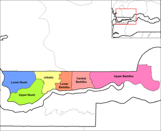
Upper Baddibu was one of the six districts of the North Bank Division of The Gambia. Its main town was Farafenni. The North Bank Division is now the Kerewan Local Government Area, and the former Upper Baddibu District is now divided into an Illiasa District and a Sabach Sanjal District.

Sandu District is one of the four districts of the Upper River Division of The Republic of Gambia. It contains the town of Diabugu.

La Peraleja is a municipality located in the province of Cuenca, Castile-La Mancha, Spain. According to the 2004 census (INE), the municipality has a population of 139 inhabitants.

Coreses is a municipality located in the province of Zamora, Castile and León, Spain. According to the 2009 census (INE), the municipality has a population of 1,156 inhabitants.

Cubillos is a municipality located in the province of Zamora, Castile and León, Spain. According to the 2009 census (INE), the municipality has a population of 363 inhabitants.

Yaho is a department in the Balé Province in southern Burkina Faso. Its capital lies at the town of Yaho. According to the 1996 census the department had a total population of 14,257. As of August 2009 the department's population has increased to 16,424.
Nordé is a village in the Zimtenga Department of Bam Province in northern-central Burkina Faso. It has a population of 305.
Bohum Kunda is a town in the Gambia. It is located in Fulladu East District in the Upper River Division. As of 2009, it has an estimated population of 722.
Boro Dampha Kunda is a town in the Gambia. It is located in Wuli District in the Upper River Division. As of 2009, it has an estimated population of 353.
Chamoi Bunda is a town in the Gambia. It is located in Fulladu East District in the Upper River Division. As of 2009, it has an estimated population of 785.
Keur-Macene or Keurmacen is a town and urban commune in the Trarza Region of south-western Mauritania, located on the border with Senegal.
Kokele is a small town and commune in the Cercle of Bougouni in the Sikasso Region of southern Mali. In 1998 the commune had a population of 5,753.
Cortês is a city in the state of Pernambuco, Brazil. It is 149 km away from the state capital Recife, and has an estimated population of 12,560 inhabitants.