
The Gambia River is a major river in West Africa, running 1,120 kilometres (700 mi) from the Fouta Djallon plateau in north Guinea westward through Senegal and The Gambia to the Atlantic Ocean at the city of Banjul. It is navigable for about half that length.

Lower River Division is one of the five administrative divisions of the Gambia. Its capital is Mansa Konko. The city and area council elections were held during April 2002, when Wally S.M. Sanneh, an APRC candidate became the Mayor, winning unopposed. The council was led by Alliance for Patriotic Reorientation and Construction (APRC), which won all the 12 seats.

Upper River was one of the five Divisions of the Gambia. Its capital was Basse Santa Su. It was subsequently reorganised as the Basse Local Government Area, without any change in the area covered.

Foday Musa Suso is a Gambian musician and composer. He is a member of the Mandinka ethnic group, and is a griot. Griots are the oral historians and musicians of the Mandingo people who live in several west African nations. Griots are a living library for the community providing history, entertainment, and wisdom while playing and singing their songs. It is an extensive verbal and musical heritage that can only be passed down within a griot family.
The Gambia is subdivided into 43 districts. They are listed below by Local Government Area, each with its population at the 15 April 2013 census.

Wuli District was one of the four districts of the former Upper River Division of the Gambia. The Upper River Division is now the Basse Local Government Area. Wuli was established as a parliamentary constituency in 1962 and was divided into Wuli West District and Wuli East District in 1987. The name derives from the historical region and former Mandinka kingdom of Wuli.
Baja Kunda is a town in eastern Gambia. It is located in Wuli District in the Upper River Division. As of 2008, it has an estimated population of 5,924.
The Karoninka people are an ethnic group in West Africa related to the Jola. They live mainly in Casamance, Senegal, on the right bank of the Casamance River and the islands in the mouth, but also in The Gambia.
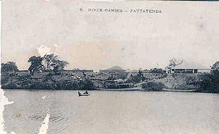
Fattatenda is a small village in eastern Gambia on the Gambia River. It is located in Wuli District in the Upper River Division. As of 2009, it has an estimated population of 49. In 1829, the King of Wuli granted the British a trading concession of one mile square at Fattatenda. It was the main upriver entrepot for trade on the Gambia river, exchanging cloth and guns for gold and ivory coming from Bundu to the east. Fattatenda was thereby linked to the French fort and trading post of Bakel on the Senegal River and the Trans-Saharan caravan routes. The ruins of commercial buildings are still visible today.
Banni is a village in the Gambia. It is located in Wuli District in the Upper River Division. As of 2009, it has an estimated population of 461.
Bantango Koto is a village in the Gambia. It is located in Wuli District in the Upper River Division. As of 2009, it has an estimated population of 327.
Barrow Kunda is a town in the Gambia. Barrow is the name of the Alkalo and Kunda means compound. It is located in Wuli District in the Upper River Division. There is another Barrow Kunda located in Foni Kansala district which is not to be confused with this Barrow Kunda. The Barrow Kunda in Foni Kansala District (Bwiam) has a newly built modern hospital and also a new indoor market which as of mid-2010 is still unopened. The main road S. Bank Road runs through the village. The Alkalo is intending to put the town on the map as a modern town so he is offering land to foreigners who would like to settle in this rural location at a lower cost compared to other more coastal or town based areas. A growing number of foreign nationals have bought and own land in Barrow Kunda. There are also some new developments due to begin construction in 2012, so this village although quiet and rural is set to become modern whilst retaining its calm and peaceful rural location. Those who want rural but modern should consider Barrow Kunda in Foni Kansala District (Bwiam). The Barrow Kunda in Wuli District has as of 2009, an estimated population of 1 730.
Boro Dampha Kunda is a town in the Gambia. It is located in Wuli District in the Upper River Division. As of 2009, it has an estimated population of 353.
Boro Kanda Kassy is a town in the Gambia. It is located in Wuli District in the Upper River Division. As of 2009, it has an estimated population of 1091.
Boro Modi Bane is a town in the Gambia. It is located in Wuli District in the Upper River Division. As of 2009, it has an estimated population of 231.
Brifu is a town in the Gambia. It is located in Wuli District in the Upper River Division. As of 2009, it has an estimated population of 1 440.
Chamoi Bunda is a town in the Gambia. It is located in Wuli District in the Upper River Division. As of 2009, it has an estimated population of 785.
Sutukoba, sometimes referred to as Sutuko, is a village in The Gambia located in the Upper River Region, 332 km east of the capital Banjul and 38 km northeast of the regional capital Basse Santa Su. The population in 2013 was 3317.
Wuli was a kingdom located on the north bank of the Gambia River in what is now the eastern portion of The Gambia and the Tambacounda region of Senegal. It was ruled by the Wally family. The capital was located in the village of Bantunding.