
Khotang District is one of 14 districts of Province No. 1 of eastern Nepal. The district, with Diktel as its district headquarters, covers an area of 1,591 km2 (614 sq mi) and has a population (2021) of 206,312. The district has been bordered by Bhojpur District in the east, Udayapur district in the south, Okhaldhunga district in the west and Solukhumbu district in the North. In this district there are 2 municipalities and 8 rural/urban municipalities.

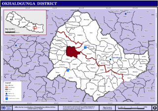
Okhaldhunga District is one of 14 districts of Province No. 1 in eastern Nepal. The district, with Okhaldhunga as its district headquarters, covers an area of 1,074.5 km2 (414.9 sq mi) and had a population of 156,702 in 2001 and 147,984 in 2011.

Solukhumbu District (Nepali: सोलुखुम्बु जिल्ला[solukʰumbu], Sherpa: ཤར་ཁུམ་བུ་རྫོང་།, Wylie: shar khum bu dzong) is one of 14 districts of Province No. 1 of eastern Nepal. As the name suggests, it consists of the subregions Solu and Khumbu.
Wambule is a Kiranti language language spoken by the Wambule Rai, one of the Rai groups belonging to the Kiranti (किरान्ती) ethnolinguistic family of eastern Nepal. Wambule is spoken by more than 5000 people living around the confluence of the Sunkosi (सुनकोसी) and Dudhkosi (दूधकोसी) rivers near Kui-Bhir Hill. The Wambule-speaking area comprises the southernmost part of Okhaldhunga district, the westernmost part of Khotang district, the northernmost part of Udayapur district, and the northeasternmost part of Sindhuli district.
Prapcha is a village development committee in Okhaldhunga District in the Sagarmatha Zone of mid-eastern Nepal. At the time of the 1991 Nepal census it had a population of 1259 living in 249 individual households.
Bilandu is a village development committee in Okhaldhunga District in the Sagarmatha Zone of mid-eastern Nepal. At the time of the 1991 Nepal census it had a population of 2279 living in 431 individual households. On December 15, 2010 a plane crashed in the forest of Bilandu, near the village of Shreechaur in the adjacent village development committee.
Jyamire, Okhaldhunga is a market in Siddhicharan Municipality in Okhaldhunga District in the Sagarmatha Zone of mid-eastern Nepal. This village center was merged to the Municipality in May 2014. At the time of the 1991 Nepal census it had a population of 2344 residing in 422 individual households.
Katunje is a village development committee in Okhaldhunga District in the Sagarmatha Zone of mid-eastern Nepal. At the time of the 1991 Nepal census, it had a population of 4027 living in 824 individual households.
Khiji Phalate is a part of Khiji Chandeshwari it has village development committee in Okhaldhunga District in the Sagarmatha Zone of mid-eastern Nepal. At the time of the 1991 Nepal census it had a population of 2944 living in 459 individual households.
Rajadip is a village development committee in Okhaldhunga District in the Sagarmatha Zone of mid-eastern Nepal. At the time of the 1991 Nepal census it had a population of 1784 living in 370 individual households.
Raniban, Sagarmatha is a village development committee in Okhaldhunga District in the Sagarmatha Zone of mid-eastern Nepal. At the time of the 1991 Nepal census it had a population of 1874 living in 372 individual households.
Sisneri is a village development committee in Okhaldhunga District in the Sagarmatha Zone of mid-eastern Nepal. At the time of the 1991 Nepal census it had a population of 3542 living in 636 individual households.
Thoksela is a village development committee in Okhaldhunga District in the Sagarmatha Zone of mid-eastern Nepal. At the time of the 1991 Nepal census it had a population of 2128 living in 651 individual households.
Ubu, Nepal is a Village Development Committee in Okhaldhunga District in the Province No. 1 of mid-eastern Nepal. At the time of the 1991 Nepal census it had a population of 3075 residing in 604 individual households.
Yasam, Nepal is a village development committee in Okhaldhunga District in the Province No. 1 of mid-eastern Nepal. At the time of the 1991 Nepal census it had a population of 1661 living in 330 individual households.
Devisthan, Myagdi is a village development committee in Myagdi District in the Dhaulagiri Zone of western-central Nepal. At the time of the 1991 Nepal census it had a population of 3225 people living in 618 individual households.
Sanghutar is a village development committee in Ramechhap District in the Janakpur Zone of north-eastern Nepal. At the time of the 1991 Nepal census it had a population of 2,177 people living in 394 individual households. The VDC has a small market called Sanghutar Bazaar, situated in the bank of the Likhu River and bordering Okhaldhunga District. The bazaar is flat land near to the bridge ; therefore, its name is Sanghutar. It is a main commercial center of many neighboring villages of Ramechhap and Okhaldhunga District with a higher secondary school called Himaganga.

Siddhicharan is a municipality and the district headquarter of Okhaldhunga District in Province No. 1 of Nepal that was established in May 2014 by merging the two former Village development committees Andheri, Thulachhap, Jyamire, Salleri, Rumjatar and Okhaldhunga. It is named after the Nepali poet Siddhicharan Shrestha. At the time of the 2011 Nepal census it had a population of 27,995 people living in 6,994 individual households.
Srichaur is a village development committee in Okhaldhunga District in the Sagarmatha Zone of mid-eastern Nepal. At the time of the 1991 Nepal census it had a population of 2388 living in 437 individual households. On December 15, 2010 a plane crashed in the forest of Bilandu, in the southwestern part of Shreechaur VDC.
