The Guildhall School of Music and Drama is a conservatoire and drama school located in the City of London, United Kingdom. Established in 1880, the school offers undergraduate and postgraduate training in all aspects of classical music and jazz along with drama and production arts. The school has students from over seventy countries. It was ranked the number one UK conservatoire in the 2021 Guardian league tables for music and as the sixth university in the world for performing arts in the 2020 QS World University Rankings.

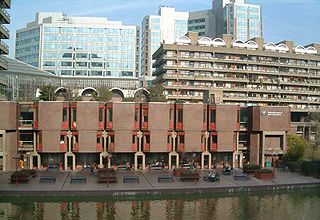
The Barbican Estate, or Barbican, is a residential complex of around 2,000 flats, maisonettes, and houses in central London, England, within the City of London. It is in an area once devastated by World War II bombings and densely populated by financial institutions, 1.4 miles (2.2km) north east of Charing Cross. Originally built as rental housing for middle and upper-middle-class professionals, it remains to this day an upmarket residential estate. It contains, or is adjacent to, the Barbican Arts Centre, the Museum of London, the Guildhall School of Music and Drama, the Barbican public library, the City of London School for Girls and a YMCA, forming the Barbican Complex.

The Museum of London documents the history of the UK's capital city from prehistoric to modern times. It is located in the City of London on the London Wall, close to the Barbican Centre and is part of the Barbican complex of buildings created in the 1960s and 1970s to redevelop a bomb-damaged area of the city. The museum is the largest urban history collection in the world, with more than six million objects.

Minories is the name of a small former administrative unit, and also of a street in central London. Both the street and the former administrative area take their name from the Abbey of the Minoresses of St. Clare without Aldgate.

Goswell Road, in Central London, is an end part of the A1. The southern part ends with one block, on the east side, in City of London; the rest is in the London Borough of Islington, the north end being Angel. It crosses Old Street/Clerkenwell Road. In the north it splits Clerkenwell from Finsbury; the south was sometimes used as a demarcator but all but the southern corporate/legal/financial end in the modern era forms the heart of the highly developed mixed-use district Barbican.
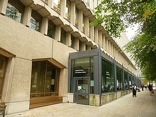
The Guildhall Library is a public reference library specialising in subjects relevant to London. It is administered by the Corporation of London, the government of the City of London, which is the historical heart of London, England.

The Jubilee Walkway is an official walking route in London. It was originally opened as the Silver Jubilee Walkway to commemorate Queen Elizabeth II's accession; the Queen herself opened it on 9 June 1977 during her silver jubilee celebrations. The intention was to connect many of London's major tourist attractions and it is now one of seven such walks within the Mayor of London's strategic walking routes. Its length is 15 miles.

Charterhouse Street is a street on the north side of Smithfield in the City of London. The road forms part of the City’s boundary with the neighbouring London Boroughs of Islington and Camden. It connects Charterhouse Square and Holborn Circus, crossing Farringdon Road and running along a number of historical sites, including Smithfield Market.

Croydon Central Library is Croydon's main public library located inside the Croydon Clocktower in Croydon, south London. It is owned by the London Borough of Croydon on behalf of Croydon Council. The library is located on four floors inside the building. There are also children's reading sessions.

The Museum of Immigration and Diversity is a British museum at 19 Princelet Street in Spitalfields, in the London Borough of Tower Hamlets. The Grade II listed building in which the museum is located was a house built in 1719 for the Huguenot silk merchant Peter Abraham Ogier.

St Alphege or St Alphage London Wall was a church in Bassishaw Ward in the City of London, built directly upon London Wall. It was also known as St Alphege Cripplegate, from its proximity to Cripplegate. It is now operated as St Alphege Gardens.
The London Centre for Arts and Cultural Exchange (LCACE) is a university initiative promoting the exchange of knowledge and expertise with the capital's arts and cultural sectors. The initiative was formed in 2004 to encourage collaboration between its partner universities and London's arts and cultural sectors. LCACE was initially funded from the Higher Education Funding Council of England's HEIF 2 Fund. The initiative is based at Somerset House and aims to produce networking and information-based events to highlight formal Knowledge transfer initiatives such as those supported by the Arts and Humanities Research Council.

The Barbican Centre is a performing arts centre in the Barbican Estate of the City of London and the largest of its kind in Europe. The centre hosts classical and contemporary music concerts, theatre performances, film screenings and art exhibitions. It also houses a library, three restaurants, and a conservatory. The Barbican Centre is member of the Global Cultural Districts Network.
Whitecross Street is a short street in Islington, in Inner London. It features an eponymous street market and a large housing estate.

Beech Street is a street in the City of London. It was formerly known as Beech Lane and was named after Nicholas de la Beche, a lieutenant of the Tower of London in the reign of Edward III in the 14th century.

The Barbican Conservatory is the second largest conservatory in London, located at the Barbican Centre. It houses more than 2,000 species of plants and trees, as well as terrapins and koi carp. The conservatory covers 23,000 square feet (2,100 m2), and is located on top of the theatre's fly tower.

Trinity Church Square, formerly known as Trinity Square, is a garden square in Newington in the London Borough of Southwark.

King Square is a square in central London, in the St Luke's area of the London Borough of Islington. It is at the corner of Lever Street and Central Street, and shares in King Square Gardens to the west.

The Jugged Hare is a public house and restaurant at 49 Chiswell Street, between Barbican and Moorgate underground stations in the City of London.

The Centre for Music was a proposed concert hall in the City of London. The City announced on 18 February 2021 that the project would not be progressed.


