
Kamarupi Prakrit is the postulated Middle Indo-Aryan (MIA) Prakrit language used in ancient Kamarupa. This language has been derived from Gauda-Kamarupi Prakrit and the historical ancestor of the Kamatapuri lects and the modern Assamese language; and can be dated prior to 1250 CE, when the proto-Kamta language, the parent of the Kamatapuri lects, began to develop. Though not substantially proven, the existence of the language that predated the Kamatapuri lects and modern Assamese is widely believed to be descended from it.

Kamrup Rural district, or simply Kamrup district, is an administrative district in the state of Assam in India formed by dividing the old Kamrup district into two in the year 2003; other being Kamrup Metropolitan district, named after the region it constitutes. This district, along with Nalbari, Barpeta, Kamrup Metropolitan, Bajali and Baksa districts has been created from the Undivided Kamrup district. Rangiya is the Sub-District of Kamrup.

The Dooars or Duars are the alluvial floodplains in eastern-northeastern India and southern Bhutan that lie south of the outer foothills of the Himalayas and north of the Brahmaputra River basin. This region is about 30 km (19 mi) wide and stretches over about 350 km (220 mi) from the Teesta River in West Bengal to the Dhansiri River in Udalguri district of Assam. The region forms the gateway to Bhutan. It is part of the Terai-Duar savanna and grasslands ecoregion.

Barpeta is a town in Barpeta district of the state of Assam in India and is district headquarters. The city is located 90 kilometres (56 mi) north west of Guwahati and is one of the major cities in Western Assam. It is also called Satra Nagari of Assam due to the presence of various Vaishnavite Satras in the vicinity.

Nalbari is a small town in Nalbari district in the Indian state of Assam. Nalbari is also the headquarters of Nalbari District.

Rangiya also known as Rangia, is a major city of Lower Assam division and a municipal board located in the Kamrup district of Assam, India. Rangiya is also the headquarters of Kamrup district, and Rangiya serves as the Sub-divisional headquarter of Rangiya Sub-division. One of Rangiya's significant features is its role as the divisional headquarter of the Northeast Frontier Railway, which is one of the major railway zones in India. Baralia river flows through the heart of the city. The Redhorn Division of the Indian Army is located just three kilometers from the city.

The Rabha people are a Tibeto-Burmese ethnic group who live mostly in the Northeast Indian state of Assam, with a lesser population in the adjacent state of West Bengal. They primarily inhabit the plains of Lower Assam and the Dooars, while some are found in the Garo Hills. Most of the Rabhas of Dooars refer to themselves as Rabha, but some of them often declare themselves as Kocha.

The Karbi language is a Tibeto-Burman language spoken by the Karbi people of Northeastern India.
Kamrup or Kamarupa or variation may refer to:

Kamrup Metropolitan district is one of the 35 districts in Assam state in north-eastern India. It was carved out of the erstwhile undivided Kamrup district in 2003 and covers an area equivalent to the area under the jurisdiction of the Guwahati Metropolitan Development Authority area. Dispur Legislative Assembly Constituency in Kamrup Metro district with 3.53 lakh voters is the largest constituency in Assam.
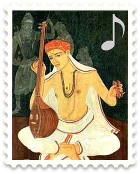
Kamrupi Lokgeet is popular form of folk music that expresses thoughts and emotion of the Kamrupi people. The songs are derived from Ancient Kamrup. The language of Kamrupi lokgeet are different dialects and ancestral forms of Assamese, including Early Assamese, Kamrupi dialects and Standard Assamese.
Badgaon or Bargaon may refer to the following places in India:
Chaygaon is a town in Kamrup district of Assam, India; situated on the south bank of the Brahmaputra river. It is 38 km from major town Guwahati. The town is known for "Maa Chandika Devalaya", a Shakti Peeth, where thousands of devotees visit during Durga Puja. Historical "Mer Ghar" of Chand Sadagar situated in Champak Nagar, Chaygaon.
Kamrupi dialects are a group of regional dialects of Assamese, spoken in the Kamrup region. It formerly enjoyed prestige status. It is one of two western dialect groups of the Assamese language, the other being Goalpariya. Kamrupi is heterogeneous with three subdialects— Barpetia dialect, Nalbariya dialect and Palasbaria dialect.

Kamrup is the modern region situated between two rivers, the Manas and the Barnadi in Western Assam, with the same territorial extent as the Colonial and post-Colonial "Undivided Kamrup district". It was the capital region of two of the three dynasties of Kamarupa and Guwahati, the current political center of Assam, is situated here. It is characterized by its cultural artifacts.

Lower Assam division is one of the 5 administrative divisions of Assam in India. It was formed in 1874, consisting of the undivided Kamrup district of Western Assam, undivided Darrang and Nagaon districts of Central Assam and Khasi & Jaintia hills of Meghalaya, created for revenue purposes. The division is under the jurisdiction of a Commissioner, who is stationed at Guwahati. The division currently covers the Western Brahmaputa Valley. Shri Jayant Narlikar, IAS is the current Commissioner of Lower Assam division.
The Kamrupi people are a linguistic group that speak the Kamrupi dialects of Assamese and are found in the colonial Kamrup district region of Assam, India.
Bargaon is a village in Kamrup rural district, in the state of Assam, India, situated in north bank of river Brahmaputra.

Pub Kamrup College, established in 1972, is a general degree college situated at Baihata Chariali in Kamrup district, Assam. This college is affiliated with the Gauhati University. The college fraternity as well as the locality at large is thankful to the concern doyens for their able guidance and leadership in the act of initiation of the college. Started with Arts stream, there are a total of 59 regular teachers being engaged in all the three faculties- Arts, Science and Vocational Course, and in a few professional courses in the college at a present.

