Barker Meadow Reservoir

Last updated
Barker Reservoir
Nederland colorado2.jpg
USA Colorado relief location map.svg
Red pog.svg
Barker Reservoir
Usa edcp relief location map.png
Red pog.svg
Barker Reservoir
Location Boulder County, Colorado, United States
Coordinates 39°57′55″N105°29′34″W / 39.96528°N 105.49278°W / 39.96528; -105.49278 Coordinates: 39°57′55″N105°29′34″W / 39.96528°N 105.49278°W / 39.96528; -105.49278
Type reservoir
Basin  countriesUnited States
Surface area1.70 km2 (0.66 sq mi)
Average depth8.3 m (27 ft)
Max. depth36.6 m (120 ft)
Water volume14.185×10^6 m3 (11,500 acre⋅ft) [1]
Residence time 104 days
Surface elevation8,183 ft (2,494 m)

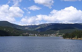
Barker Reservoir is a water supply reservoir in the Colorado Front Range located near the town of Nederland, Colorado in southwestern Boulder County.

Barker Dam Barker Dam, Nederland Colorado.jpg
Barker Dam

Barker Dam provides water to a downstream hydroelectric power generating facility, and its reservoir provides water to the city of Boulder, Colorado. In 1908, the Central Colorado Power Company began construction of Barker Dam to provide electricity to nearby mining communities and the city of Denver. Completed in 1910, the dam and Barker Reservoir were named for the owner of the land, Mrs. Hannah Connell Barker. Mrs. Barker refused to sell the land to the utility but was eventually forced to do so through a process similar to the contemporary legal procedure of eminent domain. [2] The dam was constructed by hauling concrete and other materials along a specially constructed spur of the Switzerland Trail narrow-gauge railroad, which went bankrupt and was broken up in 1919. [3]

In 2001 the city of Boulder purchased the reservoir, dam, and associated facilities. The city operates the reservoir primarily for municipal water supply and secondarily to generate hydroelectric power. [4] An aqueduct with an inlet just below the dam supplies water to Kossler Reservoir. There is then a 1828 foot drop to a hydroelectric plant near the base of Boulder Canyon, several miles downstream. [2]

Related Research Articles

Hoover Dam Dam in Clark County, Nevada, and Mohave County, Arizona, US

Hoover Dam is a concrete arch-gravity dam in the Black Canyon of the Colorado River, on the border between the U.S. states of Nevada and Arizona. It was constructed between 1931 and 1936 during the Great Depression and was dedicated on September 30, 1935, by President Franklin D. Roosevelt. Its construction was the result of a massive effort involving thousands of workers, and cost over one hundred lives. Originally known as Boulder Dam from 1933, it was officially renamed Hoover Dam for President Herbert Hoover by a joint resolution of Congress in 1947.

Hydroelectricity Electricity generated by hydropower

Hydroelectricity, or hydroelectric power, is electricity produced from hydropower. In 2015, hydropower generated 16.6% of the world's total electricity and 70% of all renewable electricity, and was expected to increase by about 3.1% each year for the next 25 years.

The Salt River Project (SRP) is the umbrella name for two separate entities: the Salt River Project Agricultural Improvement and Power District, an agency of the state of Arizona that serves as an electrical utility for the Phoenix metropolitan area, and the Salt River Valley Water Users' Association, a utility cooperative that serves as the primary water provider for much of central Arizona. It is one of the primary public utility companies in Arizona.

New Bullards Bar Dam Dam in Yuba County, California

New Bullards Bar Dam is a variable radius concrete arch dam constructed in the early 1960s in California on the North Yuba River. Located near the town of Dobbins in Yuba County, the dam forms the New Bullards Bar Reservoir, which can hold about 969,600 acre⋅ft (1,196,000 dam3) of water. The dam serves for irrigation, drinking water and hydroelectric power generation.

Colorado-Big Thompson Project

The Colorado-Big Thompson Project is a federal water diversion project in Colorado designed to collect West Slope mountain water from the headwaters of the Colorado River and divert it to Colorado's Front Range and plains. In Colorado, approximately 80% of the state's precipitation falls on the West Slope, in the Rocky Mountains, while around 80% of the state's growing population lives along the East Slope, between the cities of Fort Collins and Pueblo.

Reservoir Storage space for fluids

A reservoir is most commonly an enlarged natural or artificial lake created using a dam to store water.

Lake Tapps

Lake Tapps is a reservoir in Pierce County, Washington. It was created in 1911 by Puget Sound Power & Light and operated for hydroelectric power until it ceased power production in 2004. In December 2009 PSE sold the reservoir to the Cascade Water Alliance, a municipal corporation whose members are five King County cities and two water and sewer districts. Cascade provides drinking water to more than 350,000 residents and more than 20,000 businesses. It plans to eventually use Lake Tapps as a municipal water supply source for customers of its members.

Srisailam Dam Dam in Sri Sailam, Kurnool district, Andhra Pradesh, India

The Srisailam Dam is constructed across the Krishna River in Kurnool district, Andhra Pradesh near Srisailam temple town and is the 2nd largest capacity working hydroelectric station in the country.

Douglas Dam Dam in Sevier County, Tennessee, United States

Douglas Dam is a hydroelectric dam on the French Broad River in Sevier County, Tennessee, in the southeastern United States. The dam is operated by the Tennessee Valley Authority (TVA), which built the dam in record time in the early 1940s to meet emergency energy demands at the height of World War II. Douglas Dam is a straight reinforced concrete gravity-type dam 1705 feet long and 202 feet high, impounding the 28,420-acre (11,500 ha) Douglas Lake. The dam was named for Douglas Bluff, a cliff overlooking the dam site prior to construction.

Childs-Irving Hydroelectric Facilities United States historic place

Childs-Irving Hydroelectric Facilities consisted of two 20th-century power plants, a dam, and related infrastructure along or near Fossil Creek in the U.S. state of Arizona. The complex was named an Historic Mechanical Engineering Landmark in 1971 and was added to the National Register of Historic Places 20 years later. Decommissioned in 2005, the plants no longer produce electricity, and much of the infrastructure—including the dam, the Irving Power Plant, and thousands of feet of concrete flumes—have been removed, and the creek's original flow has been restored.

Run-of-the-river hydroelectricity

Run-of-river hydroelectricity (ROR) or run-of-the-river hydroelectricity is a type of hydroelectric generation plant whereby little or no water storage is provided. Run-of-the-river power plants may have no water storage at all or a limited amount of storage, in which case the storage reservoir is referred to as pondage. A plant without pondage is subject to seasonal river flows, thus the plant will operate as an intermittent energy source. Conventional hydro uses reservoirs, which regulate water for flood control, dispatchable electrical power, and the provision of fresh water for agriculture.

Hannah Connell Barker (1844–1918) was an early resident of Boulder, Colorado. Barker was a teacher, civic leader, businesswoman and land developer in an era when industrious women were not commonly recognized for their contributions. Among other things, Barker served as a teacher; as director of the Boulder Bank; and was instrumental in platting and developing significant parts of the City of Boulder. She also owned the land that was used for the construction of Barker Meadow Reservoir, Boulder's primary source of water.

Environmental impact of reservoirs

The environmental impact of reservoirs comes under ever-increasing scrutiny as the global demand for water and energy increases and the number and size of reservoirs increases.

Colorado River Storage Project

The Colorado River Storage Project is a United States Bureau of Reclamation project designed to oversee the development of the upper Colorado River basin. The project provides hydroelectric power, flood control and water storage for participating states along the upper portion of the Colorado River and its major tributaries.

Samanala Dam Dam in Balangoda

The Samanala Dam is a dam primarily used for hydroelectric power generation in Sri Lanka. Commissioned in 1992, the Samanalawewa Project is the third-largest hydroelectric scheme in the country, producing 405 GWh of energy annually. It was built with financial support from Japan and the United Kingdom. It is notable for a large leak on its right bank. Power production continues as planned despite the leakage, and the water from the leak now provides two thirds of the water issued by the reservoir for agriculture in downstream areas.

Kpong Dam Dam in Akuse

The Kpong Dam, also known as the Akuse Dam, is a hydroelectric power generating dam on the lower Volta River near Akuse in Ghana. It is owned and operated by Volta River Authority. It was constructed between 1977 and 1982. Its power station has a capacity of 148 megawatts (198,000 hp) with all four units running, though the total nameplate capacity is 160 megawatts (210,000 hp).

Green Mountain Reservoir Dam in Summit County, Colorado

Green Mountain Reservoir lies at the northern end of Summit County, Colorado along the Blue River. The Green Mountain Dam was built between 1938 and 1942 by the United States Bureau of Reclamation. The reservoir and its dam store water to benefit Colorado's Western Slope. Created by President Roosevelt as part of the Colorado-Big Thompson Project in 1937, Green Mountain was the first facility to be constructed. This is because it represents a great compromise that made the C-BT project possible: it compensates the Western Slope for water diverted to cities in Northern Colorado from Lake Granby further upstream on the Colorado River. Water from Green Mountain Dam is released either over the spillway, through the dam, or through the hydroelectric powerplant at the dam's base. The Green Mountain Power Plant has the capacity to generate up to 21,000 kilowatts, using two generators. Combined with the other five Federal power plants on the C-BT, enough electricity is produced annually to power almost 60,000 American homes.

Moccasin Dam is a small dam on Moccasin Creek in Tuolumne County, California, in the town of Moccasin, west of Yosemite. It holds the Moccasin Reservoir. The dam, reservoir and associated hydroelectric power plant are part of the Hetch Hetchy Project, which provide water and power to the city of San Francisco. The dam is located near the junction of Highway 120 and Highway 49.

Superior Dam Dam in Huron RiverSuperior Township, Michigan

The Superior Dam is a hydroelectric barrage dam crossing the Huron River. It is located in Superior Township in Washtenaw County in the U.S. state of Michigan. It was completed in 1920 and currently provides hydroelectricity to the nearby city of Ann Arbor, which owns and maintains the dam and power station.

References

  1. "Report on Barker Reservoir Boulder County Colorado EPA Region VIII Working Paper No. 765". US Environmental Protection Agency. June 1977.Cite journal requires |journal= (help)
  2. 1 2 "History of Barker Reservoir". City of Boulder, Colorado. Archived from the original on 2007-10-04.
  3. Crossen, Forest (1978). The Switzerland Trail of America. Robinson Press. ISBN   978-0-913730-24-9.
  4. "City of Boulder Water Sources". Archived from the original on 2012-06-07.