
Exmoor is loosely defined as an area of hilly open moorland in west Somerset and north Devon in South West England. It is named after the River Exe, the source of which is situated in the centre of the area, two miles north-west of Simonsbath. Exmoor is more precisely defined as the area of the former ancient royal hunting forest, also called Exmoor, which was officially surveyed 1815–1818 as 18,810 acres (7,610 ha) in extent. The moor has given its name to a National Park, which includes the Brendon Hills, the East Lyn Valley, the Vale of Porlock and 55 km (34 mi) of the Bristol Channel coast. The total area of the Exmoor National Park is 692.8 km2 (267.5 sq mi), of which 71% is in Somerset and 29% in Devon.

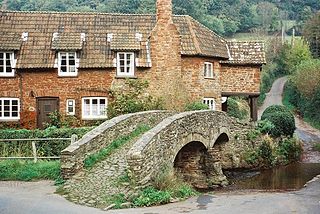
Brompton Regis is a village and civil parish in the Somerset West and Taunton district of Somerset, England about 5 miles (8.0 km) north-east of Dulverton. It is situated on the River Pulham in the Brendon Hills within the Exmoor National Park, close to Wimbleball Lake, a water supply reservoir constructed in the 1970s and completed in 1979. According to the 2011 census the village had a population of 449. The parish boundary is marked by the River Exe which is crossed by the medieval Chilly Bridge and Hele Bridge. The Haddeo is crossed by Bury Bridge.

Brushford is a village and civil parish 2 miles (3.2 km) south of Dulverton and 12 miles (19 km) north of Tiverton in Devon, in the Somerset West and Taunton district of Somerset, England. According to the 2001 census it had a population of 535 in 243 households, reducing to 519 at the 2011 Census. It covers an area of 1,149 hectares (11 km2) of which 3 hectares (0.030 km2) is within the Exmoor National Park.
Allerford is a village in the county of Somerset, England, located within Exmoor National Park, and is part of the parish of Selworthy in the district of Somerset West and Taunton. It appears in Domesday Book as “Alresford – forda Ralph de Limesy Mill”.

Withypool is a small village in Somerset, England, near the centre of Exmoor National Park and close to the border with Devon. The word Withy means "willow". The civil parish, known as Withypool and Hawkridge, covers 3,097 hectares, includes the village of Hawkridge and has a population around 201.

The Tarr Steps is a clapper bridge across the River Barle in the Exmoor National Park, Somerset, England. They are located in a national nature reserve about 2.5 miles (4 km) south east of Withypool and 4 miles (6 km) north west of Dulverton.

Dunster Working Watermill is a restored 18th century watermill, situated on the River Avill, close to Gallox Bridge, in the grounds of Dunster Castle in Dunster, Somerset, England. It is a Grade II* listed building.

Exford is a rural village at the centre of Exmoor National Park, 7 miles (11 km) north-west of Dulverton, and 10 miles (16 km) south-west of Minehead, in Somerset, England. Less than a mile away is the hamlet of Lyncombe.
Oare is a village and civil parish on Oare Water on Exmoor in the Somerset West and Taunton district of Somerset, England. The parish includes the hamlet of Oareford and the village of Culbone which contains its own tiny church.

Simonsbath is a small village high on Exmoor in the English county of Somerset. It is the principal settlement in the Exmoor civil parish, which is the largest and most sparsely populated civil parish on Exmoor, covering nearly 32 square miles (83 km2) but with a population, at the time of the 2001 census, of 203 in 78 households, reducing to 156 at the 2011 Census. The River Exe rises from a valley to the north, and the River Barle runs through the village and is crossed by a triple-arched medieval bridge that was extensively repaired after floods in 1952.
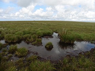
The Chains is the name given to the north-west plateau of Exmoor, Somerset, England. This plateau lies above the 1,500 feet (457 m) contour line, and includes the source of the River Barle.

Exton is a village and civil parish 5 miles (8 km) north-east of Dulverton and 9 miles (14 km) south-west of Dunster in Somerset, England. It lies on the River Exe on Exmoor. The parish includes the village of Bridgetown and covers 2,017 ha, all of which is within the National Park.

Mounsey Castle is an Iron Age irregular triangular earthwork of 1.75 hectares north west of Dulverton, Somerset, England. It has been scheduled as an ancient monument. It has been added to the Heritage at Risk register.

West Somerset is a local government district in the English county of Somerset. The council covers a largely rural area, with a population of 35,075 in an area of 740 square kilometres (290 sq mi). According to figures released by the Office for National Statistics in 2009, the population of West Somerset has the oldest average age in the United Kingdom at 52. The largest centres of population are the coastal towns of Minehead and Watchet (4,400).

Landacre Bridge carries Landacre Lane across the River Barle near Withypool on Exmoor in the English county of Somerset. It has been scheduled as an ancient monument and Grade II* listed building.

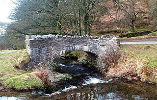
Bury Bridge at Bury in the parish of Brompton Regis within the English county of Somerset is a medieval packhorse bridge. It has been scheduled as an ancient monument and Grade II* listed building.

The Anglican Church of All Saints in Dulverton, Somerset, England was built in the 15th century and largely rebuilt in the 1850s. It is a Grade II* listed building.
Withypool Bridge carries a small road over the River Barle at Withypool in Somerset, England. It is a Grade II* listed building.


