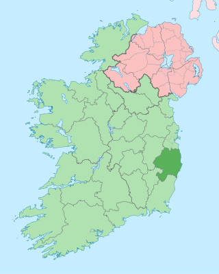
County Wicklow is a county in Ireland. The last of the traditional 32 counties, having been formed as late as 1606, it is part of the Eastern and Midland Region and the province of Leinster. It is bordered by the Irish Sea to the east and the counties of Wexford to the south, Carlow to the southwest, Kildare to the west, and South Dublin and Dún Laoghaire–Rathdown to the north.

The River Dargle is a river that flows from the Wicklow Mountains in Ireland to the Irish Sea. It forms Powerscourt Waterfall, receives the Glencree and Glencullen Rivers, and later the Glenmunder Stream / County Brook, and the Swan River at Bray, and reaches the sea at Bray Harbour.

Dún Laoghaire–Rathdown is a county in Ireland. It is in the province of Leinster and the Eastern and Midland Region. It is one of three successor counties to County Dublin, which was disestablished in 1994. It is named after the former borough of Dún Laoghaire and the barony of Rathdown. Dún Laoghaire–Rathdown County Council is the local authority for the county. The population of the county was 233,860 at the time of the 2022 census.
This is a list of the extreme points of the United Kingdom: the points that are farther north, south, east or west than any other location. Traditionally the extent of the island of Great Britain has stretched "from Land's End to John o' Groats".

This is a list of the extreme points of Ireland – the points that are farthest north, south, east or west in Ireland. It includes the Republic of Ireland and Northern Ireland.

The River Slaney is a large river in the southeast of Ireland. It rises on Lugnaquilla Mountain in the western Wicklow Mountains and flows west and then south through counties Wicklow, Carlow and Wexford for 117.5 km (73 mi), before entering St George's Channel in the Irish Sea at Wexford town. The estuary of the Slaney is wide and shallow and is known as Wexford Harbour. The catchment area of the River Slaney is 1,762 km2. The long-term average flow rate of the River Slaney is 37.4m3/s
The Victoria Cross Ranges are a set of mountain ranges in the Canadian Rockies, located to the northwest of Jasper. Of the 19 peaks contained within this range, five are named after Canadian recipients of the Victoria Cross. The area of the ranges is 678 square kilometres (262 sq mi).

The Glen of Imaal is a remote glen in the western Wicklow Mountains in Ireland. It is ringed by the Lugnaquilla massif and its foothills, including Table Mountain and Keadeen. Much of the valley is used by the Irish Army as an artillery firing range, and hill walkers who use the glen are advised to observe the times of firing practice and to refrain from picking up strange objects.
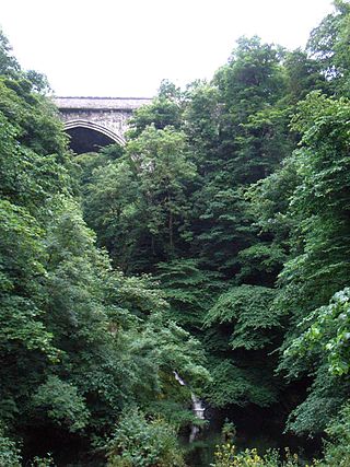
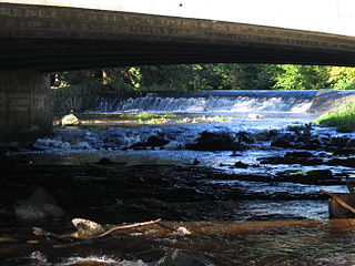
Poulaphouca, officially Pollaphuca, is the name of a waterfall and bridge on the River Liffey between County Wicklow and County Kildare. It is primarily known for its hydroelectric generating station and the associated artificial lake, known as Poulaphouca Reservoir, Poulaphouca Lake, or Blessington Lakes. The once-famous Poulaphouca Waterfall has little water running over it any longer because of the hydroelectric project.
Dalkey Hill is the northernmost of the two hills which form the southern boundary of Dublin Bay. Dalkey Hill is 140 metres high and has views over the surrounding areas : Dublin to the northwest; the Irish Sea and the mountains of Wales to the east and southeast; and Bray Head and the Wicklow Mountains to the south.

The R115 road is a regional road in counties Dublin and Wicklow in Ireland. It follows the Military Road for its entire length. The R115 is 40.5 km (25.2 mi) long; the full length of the Military Road is 57.9 km (36.0 mi).

The R759 road is a regional road in Ireland running south-east to north-west through the Sally Gap in the Wicklow Mountains, from the R755 near Roundwood in East Wicklow to the N81 in West Wicklow. The other route through the Wicklow Mountains from east to west is the Wicklow Gap which is crossed by the R756.
The R755 road is a regional road in Ireland. It runs for its entire length in County Wicklow. From the village of Kilmacanogue on the N11 national primary road it goes north/south for 36 km (22 mi) to the town of Rathdrum.
The River Vartry is a river in County Wicklow, Ireland, and an important water source for the city of Dublin.

The R117 road is a regional road in Ireland. The route (north-south) starts Harcourt Road at the end of the South Circular Road on the southside of Dublin city centre. It crosses the Grand Canal and goes through the suburbs of Ranelagh, Milltown, Windy Arbour, Dundrum, Sandyford, Stepaside and Kilternan before passing through the Scalp into County Wicklow.

Church Mountain, also called Slieve Gad, is the westernmost of the Wicklow Mountains in Ireland. It is 544 metres (1,785 ft) high. At the summit are the remains of a large ancient cairn of pagan origin. This cairn was partially destroyed and a small building, apparently a church, was built on it in the Middle Ages. Pilgrims formerly climbed the mountain during the festival of Lughnasa to visit a holy well on the summit.
Strathmore is a mansion in Killiney, Dunleary-Rathdown in Ireland, and formerly the Official residence of the Canadian Ambassador to Ireland.

Seefingan often spelt Seafingan is a mountain that straddles two county boundaries from its summit in Wicklow eastwards down into South Dublin, in Ireland. There are extensive views from the summit and there is a large megalithic cairn nearby.

Killiney Hill is the southernmost of the two hills which form the southern boundary of Dublin Bay, the other being Dalkey Hill. These two hills form part of Killiney Hill Park.

The R410 road, also called the Blessington Road, is a regional road in Ireland, located in County Wicklow and County Kildare.
