Lake Washington is a large freshwater lake adjacent to the city of Seattle. It is the largest lake in King County and the second largest natural lake in the state of Washington, after Lake Chelan. It borders the cities of Seattle on the west, Bellevue and Kirkland on the east, Renton on the south and Kenmore on the north, and encloses Mercer Island. The lake is fed by the Sammamish River at its north end and the Cedar River at its south.

The Sammamish River flows through north King County, Washington for about 14 miles (23 km), draining Lake Sammamish into Lake Washington. Along its course, the Sammamish River flows through Redmond, Woodinville, Bothell, and Kenmore.

The Okanogan River is a tributary of the Columbia River, approximately 115 mi (185 km) long, in southern British Columbia and north central Washington. It drains a scenic plateau region called the Okanagan Country east of the Cascade Range and north and west of the Columbia, and also the Okanagan region of British Columbia. The Canadian portion of the river has been channelized since the mid-1950s.
The Tioughnioga River is a 34.2-mile-long (55.0 km) tributary of the Chenango River in central New York in the United States. It drains a dissected plateau area east of the Finger Lakes at the northernmost edge of the watershed of the Susquehanna River.

The Nooksack River is a river in the northwest part of the U.S. state of Washington. It drains an area of the Cascade Range around Mount Baker, near the Canada–US border. The lower river flows through a fertile agricultural area before emptying into Bellingham Bay and, via the Strait of Juan de Fuca and the Strait of Georgia, the Pacific Ocean. The river begins in three main forks, the North Fork, Middle Fork, and South Fork. The North Fork is sometimes considered the main river. Including the North Fork, the Nooksack is approximately 75 miles (121 km) long. All three forks originate in the Mount Baker Wilderness.

The Seine River is a river in Kenora, Rainy River and Thunder Bay Districts in northwestern Ontario, Canada. It flows 240 kilometres (149 mi) from Lac des Mille Lacs to Rainy Lake.

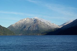
Lake Crescent is a deep lake located entirely within Olympic National Park in Clallam County, Washington, United States, approximately 17 miles (27 km) west of Port Angeles, Washington on U.S. Route 101 and nearby to the small community of Piedmont. At an official maximum depth of 624 feet (190 m), also the maximum depth of the depth sounder used to find that depth, it is officially the second deepest lake in Washington. Unofficial depth measurements of more than 1,000 feet (300 m) have been rumored in the region for years, although this figure has recently been proven false after a lake-wide bathymetric survey was performed from 2013 to 2014 by Eian Ray and Jeff Enge. The results of this survey showed the maximum depth as being 596 feet. Using GIS statistical analysis, this survey also showed the lake contains approximately 0.5 cubic miles of fresh water.

Crab Creek is a stream in the U.S. state of Washington. Named for the presence of crayfish, it is one of the few perennial streams in the Columbia Basin of central Washington, flowing from the northeastern Columbia River Plateau, roughly 5 km (3.1 mi) east of Reardan, west-southwest to empty into the Columbia River near the small town of Beverly. Its course exhibits many examples of the erosive powers of extremely large glacial Missoula Floods of the late Pleistocene, which scoured the region. In addition, Crab Creek and its region have been transformed by the large-scale irrigation of the Bureau of Reclamation's Columbia Basin Project (CBP), which has raised water table levels, significantly extending the length of Crab Creek and created new lakes and streams.

The Sol Duc River is a river in the U.S. state of Washington. About 78 miles (126 km) long, it flows west through the northwest part of the Olympic Peninsula, from the Olympic Mountains of Olympic National Park and Olympic National Forest, then through the broad Sol Duc Valley. Near the Pacific Ocean the Sol Duc River joins the Bogachiel River, forming the Quillayute River, which flows about 4 miles (6.4 km) to the Pacific Ocean at La Push. Although the Quillayute River is short, its large tributary rivers—the Sol Duc, Bogachiel, Calawah, and Dickey Rivers—drain the largest watershed of the northern Olympic Peninsula, 629 square miles (1,630 km2). The Sol Duc's watershed is the largest of the Quillayute's tributaries, at 219 square miles (570 km2).

The Crescenti cutthroat trout or the Lake Crescent cutthroat trout is a North American freshwater fish, a local form of the coastal cutthroat trout isolated in Lake Crescent in Washington. While previously attributed to a distinct subspecies Oncorhynchus clarkii crescenti, it is not currently recognized at the subspecies rank. However the cutthroat trout of Lake Crescent do remain distinct. They have the highest known gill raker and vertebrae counts of any coastal cutthroat population. The cutthroat are believed to have been isolated in Lake Crescent after a landslide blocked the eastern outflow of the lake.

The Lyre River in the U.S. state of Washington flows out of Lake Crescent in the Olympic National Park and into the Strait of Juan de Fuca. Originally referred to as "singing waters" by the Indians living near it, the river was first named Rio de Cuesta by Europeans in 1790 by Gonzalo López de Haro, but was later called River Lyre after being charted by Captain Henry Kellett in 1847.

Ferries and steamboats of Lake Crescent, Washington were used for water transport of passengers and freight before highways were built in the area in the early 1920s. Prior to highway construction, Lake Crescent was used as a route from Port Townsend into the northwestern part of the Olympic Peninsula. Ferries, steamboats and similar water craft were built and used on the lake until the Olympic Highway was completed along the south shore of the lake in 1922.

Marymere Falls is located in Olympic National Park near Lake Crescent in Washington, United States. The falls are accessed by a one-mile, well maintained, dirt trail through old-growth lowland forest consisting of fir, cedar, hemlock, and alder trees. Falls creek descends from Aurora Ridge and tumbles over Marymere Falls and then flows into Barnes Creek. It has a height of 90 feet. The falls is one of the more popular attractions in the area, due to ease of access and proximity to U.S. Highway 101.
Barnes Point is an ancient landslide delta that juts out into Lake Crescent in Clallam County, Washington. As one of the few areas of relatively flat ground near Lake Crescent, it hosts Lake Crescent Lodge, the Storm King Ranger Station of Olympic National Park, as well as several private homes. It also contains the trails which access Mount Storm King, Marymere Falls, and Barnes Creek. Barnes Creek flows through an old-growth forest, providing spawning habitat for the endemic Crescenti cutthroat trout.

Pyramid Mountain is located high above Lake Crescent's north shore. Once known as Sugarloaf Mountain, it received its present name in 1928. It contains the ruins of an old fire lookout at the summit. It dominates the view from Barnes Point and Lake Crescent Lodge. It is accessible by trail from the Spruce Railroad Trail. On a clear day, Mount Baker is visible in the Cascade Range across the Puget Sound.

Goodell Creek is a tributary of the Skagit River in the U.S. state of Washington.
The Crescent River is a 5.4-mile-long (8.7 km) tidal river in McIntosh County, Georgia, in the United States. It forms in salt marshes east of the community of Bellville Point and flows southeast, ending at a river junction where the Mud River flows northeast into Sapelo Sound and Old Teakettle Creek flows south to Doboy Sound.
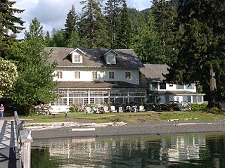
Lake Crescent Lodge, originally called Singer's Lake Crescent Tavern, is a historic resort situated on the shores of Lake Crescent west of Port Angeles, Washington. Located on the Olympic Peninsula within Olympic National Park, the Lodge is owned by the National Park Service and operated by Aramark. The Lodge resort is open seasonally from early May until the end of January with select cabins available during the winter months. Hiking and boating are popular activities for guests, and several peaks, including Mount Storm King and Pyramid Mountain, are easily accessible from the resort. Other hiking opportunities include Marymere Falls, Spruce Railroad, and Barnes Creek Trails.

Big Marsh Creek is a 15-mile (24 km) tributary of Crescent Creek in Klamath County, in the U.S. state of Oregon. The creek flows generally north from its source upstream of Big Marsh, south of Crescent Lake Junction on the eastern side of the Cascade Range. All of Big Marsh Creek and 10 miles (16 km) of Crescent Creek are parts of the National Wild and Scenic Rivers System. In turn, Crescent Creek is a tributary of the Little Deschutes River, of which 12 miles (19 km) in the same general area are also part of the national system.
Crescent Creek is a 30-mile (48 km) tributary of the Little Deschutes River in Klamath County in the U.S. state of Oregon. Beginning at Crescent Lake on the eastern flank of the Cascade Range, the river flows generally east through parts of Deschutes National Forest to meet the Little Deschutes between Crescent and La Pine.