Related Research Articles

Angelus Oaks is an unincorporated community in San Bernardino County, California, United States, and has a population of 535 as of the 2010 U.S. Census, up from an estimated population of 312 in 2000. It is surrounded by the San Bernardino National Forest and located east of San Bernardino on California State Route 38.

Lake Crescent is a deep lake located entirely within Olympic National Park in Clallam County, Washington, United States, approximately 17 miles (27 km) west of Port Angeles on U.S. Route 101 and nearby to the small community of Piedmont. At an official maximum depth of 624 feet (190 m) it is officially the second deepest lake in Washington. Unofficial depth measurements of more than 1,000 feet (300 m) have been rumored in the region for years, although this figure has recently been proven false after a lake-wide bathymetric survey was performed from 2013 to 2014 by Eian Ray and Jeff Enge. The results of this survey showed the maximum depth as being 596 feet. Using GIS statistical analysis, this survey also showed the lake contains approximately 0.5 cubic miles of fresh water.

Area code 707 is a telephone area code in the North American Numbering Plan (NANP) for the northwestern part of the U.S. state of California. It was created by a split of area code 415 on March 1, 1959. It serves part of the northern San Francisco Bay Area, as well as the North Coast. Major cities in the area code include Napa, Sebastopol, Vallejo, Benicia, Fairfield, Santa Rosa, Windsor, Healdsburg, Rohnert Park, Petaluma, Fort Bragg, Rio Vista, Crescent City, Eureka, Clearlake, Vacaville, Dixon, and Ukiah.
Scouting in British Columbia has a long history, from the 1900s to the present day, serving thousands of youth in programs that suit the environment in which they live.

Lake Wawasee is a large, natural, freshwater lake southeast of Syracuse in Kosciusko County, Indiana. It is the largest natural lake within Indiana's borders.

Mississippi Valley Council is headquartered in Quincy, Illinois, and is served by Black Hawk Lodge, Order of the Arrow. This council serves Scouts in Illinois, Missouri and Iowa. In 1994, Saukee Area Council merged with Southeastern Iowa Council to form Mississippi Valley Council. The Mississippi Valley Council is one of 22 local Scouting councils in Illinois.
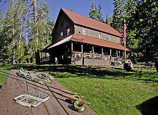
Drakesbad Guest Ranch, also known simply as Drakesbad, is a resort near Chester, California. It is located on Hot Springs Creek at the head of Warner Valley, in Lassen Volcanic National Park.

Ferries and steamboats of Lake Crescent, Washington were used for water transport of passengers and freight before highways were built in the area in the early 1920s. Prior to highway construction, Lake Crescent was used as a route from Port Townsend into the northwestern part of the Olympic Peninsula. Ferries, steamboats and similar water craft were built and used on the lake until the Olympic Highway was completed along the south shore of the lake in 1922.

The Storm King Ranger Station, also known as the Storm King Guard Station and Morgenroth Cabin, is a historic building located southeast of Barnes Point, on south shore of Lake Crescent, about 17 miles (27 km) southwest of Port Angeles, Washington. The ranger station is part of the Olympic National Park. The station was added to the National Register of Historic Places in 2007.

Rosemary Inn is a historic resort located at Barnes Point, on south shore of Lake Crescent, about 17.2 miles (27.7 km) southwest of Port Angeles, in Olympic National Park. The Rosemary Inn historic district comprises a 4.5 acres (1.8 ha) area and encompasses several historical structures built between 1914 and the mid-1930s.

Monmouth Council, BSA, established in 1917, serves all of Monmouth County, New Jersey and part of Middlesex County, New Jersey. The Council was the starting point for the landmark US Supreme Court case Boy Scouts of America v. Dale.

The Jenny Lake Ranger Station Historic District comprises an area that was the main point of visitor contact in Grand Teton National Park from the 1930s to 1960. Located near Jenny Lake, the buildings are a mixture of purpose-built structures and existing buildings that were adapted for use by the National Park Service. The ranger station was built as a cabin by Lee Mangus north of Moose, Wyoming about 1925 and was moved and rebuilt around 1930 for Park Service use. A store was built by a concessioner, and comfort stations were built to Park Service standard plans. All buildings were planned to the prevailing National Park Service Rustic style, although the ranger station and the photo shop were built from parts of buildings located elsewhere in the park.

The Glacier National Park Tourist Trails, including the Inside Trail, South Circle Trail and North Circle Trail, were established in Glacier National Park to connect a series of tourist camps and hotels established by the Great Northern Railway between 1910 and 1915. Prior to the construction of the Going-to-the-Sun Road, these trails were the primary form of circulation within the park. The trail system includes a number of bridges.
Northern Star Council is a Boy Scout Council headquartered in Saint Paul, Minnesota. The council was formerly the Viking Council and Indianhead Council until the two councils merged on July 1, 2005. The council serves communities across central Minnesota and western Wisconsin, encompassing 25 counties.

Water and Woods Field Service Council was a field service council of the Michigan Crossroads Council that served youth in the central and northeastern Lower Peninsula of Michigan. The Council was headquartered in Flint, Michigan, with service centers located in Auburn, Lansing, and Port Huron. The Water and Woods Field Service Council was the result of a merger in 2012 of Lake Huron Area Council, Blue Water Council, Tall Pine Council and Chief Okemos Council.

The following articles relate to the history, geography, geology, flora, fauna, structures and recreation in Glacier National Park (U.S.), the U.S. portion of the Waterton-Glacier International Peace Park.

The historical buildings and structures of Grand Teton National Park include a variety of buildings and built remains that pre-date the establishment of Grand Teton National Park, together with facilities built by the National Park Service to serve park visitors. Many of these places and structures have been placed on the National Register of Historic Places. The pre-Park Service structures include homestead cabins from the earliest settlement of Jackson Hole, working ranches that once covered the valley floor, and dude ranches or guest ranches that catered to the tourist trade that grew up in the 1920s and 1930s, before the park was expanded to encompass nearly all of Jackson Hole. Many of these were incorporated into the park to serve as Park Service personnel housing, or were razed to restore the landscape to a natural appearance. Others continued to function as inholdings under a life estate in which their former owners could continue to use and occupy the property until their death. Other buildings, built in the mountains after the initial establishment of the park in 1929, or in the valley after the park was expanded in 1950, were built by the Park Service to serve park visitors, frequently employing the National Park Service Rustic style of design.
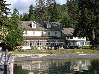
Lake Crescent Lodge, originally called Singer's Lake Crescent Tavern, is a historic resort situated on the shores of Lake Crescent west of Port Angeles, Washington. Located on the Olympic Peninsula within Olympic National Park, the Lodge is owned by the National Park Service and operated by Aramark. The Lodge resort is open seasonally from early May until the end of January with select cabins available during the winter months. Hiking and boating are popular activities for guests, and several peaks, including Mount Storm King and Pyramid Mountain, are easily accessible from the resort. Other hiking opportunities include Marymere Falls, Spruce Railroad, and Barnes Creek Trails.
Architects of the National Park Service are the architects and landscape architects who were employed by the National Park Service (NPS) starting in 1918 to design buildings, structures, roads, trails and other features in the United States National Parks. Many of their works are listed on the National Register of Historic Places, and a number have also been designated as National Historic Landmarks.
References
- ↑ Majors, Harry M. (1975). Exploring Washington. Van Winkle Publishing Co. p. 15. ISBN 978-0-918664-00-6.
Coordinates: 48°03′40″N123°47′45″W / 48.06111°N 123.79583°W
| | This Clallam County, Washington state location article is a stub. You can help Wikipedia by expanding it. |