Barnet Common

Last updated

Barnet Common
Barnet Common on an 1805 map by William Hyett.jpg
Barnet Common (centre) on an 1805 map [1]
Barnet Common
Nearest townChipping Barnet
Established16th century
Closed1815
DesignationCommon land
Barnet Common (centre) on an Ordnance Survey map published between 1873 and 1885 Chipping Barnet cropped from Map of Hertfordshire Sheet 045, Ordnance Survey, 1873-1885.jpg
Barnet Common (centre) on an Ordnance Survey map published between 1873 and 1885

Barnet Common was an area of common land to the south of the town of Chipping Barnet in what is now north London. The Common was created after a wood was cleared in the 16th century and was mostly used by local people to graze their animals. It was the location of a Digger colony and of the Barnet Physic Well at which mineral water was consumed. Part of the Common was enclosed in 1729 and the rest in 1815, leading to development on the north and south sides, and later infilling.

Contents

Extent

The Common was created by the clearance of a wood around the 16th century, [3] possibly Southaw or Suthawe wood which at one time belonged to the Abbey of St Albans. [4] It covered the area south of Chipping Barnet's Wood Street and Barnet Road, which run broadly east–west between the town centre and Barnet Gate, and went as far south as Ducks Island, Underhill, and the Dollis Brook. [3]

History

The original Eleanor Palmer almshouses in Wood Street Original Eleanor Palmer almshouses Wood Street, 1823.jpg
The original Eleanor Palmer almshouses in Wood Street
Ravenscroft Gardens, 1880 Ravenscroft Gardens 1880.jpg
Ravenscroft Gardens, 1880

Barnet Physic Well became popular during the second half of the 17th century and there was a Digger colony on the Common in 1649. [3] In the 18th and early 19th century the Common provided pasture for grazing horses which were traded at the Barnet horse fairs. [7]

In 1729, 135 acres (55 ha) of the Common were enclosed by the Lord of the Manor, the Duke of Chandos. This prevented local people from grazing their animals on that part and in return for the loss of that right, the Duke set up a charity for the poor whereby some land was designated as "fuel land" and the rent from it used to buy winter fuel for the "deserving poor". [3]

The remainder of the Common was finally enclosed in 1815 after which there was development on the north side of the Common in the Wood Street area, such as the six almshouses built by the Eleanor Palmer Trust in 1823 [5] [3] and the construction of the Barnet Union Workhouse in 1836–37 on Wellhouse Lane which led to the Physic Well. [8] Housing was built on the south side at Ducks (or Duck) Island. [9]

In 1876, James Thorne wrote in his Handbook to the Environs of London that the area around the former Common had "increased considerably" since the opening of the railway on the site of the former Barnet race course [10] in 1872. [11]

Later development in the area includes the construction of Barnet Hospital and its predecessors on the site of the former workhouse, [8] and the creation of Barnet Recreation Ground in the 1880s from some of the last remaining common land. It was of a formal design with winding serpentine walks [7] [12] and was later renamed Ravenscroft Gardens after local philanthropist James Ravenscroft. [6] Bell's Hill Burial Ground was opened in 1895. [13]

Barnet Physic Well

Barnet Physic Well, pictured in 2021 after restoration in 2018 Barnet Physic Well 05.jpg
Barnet Physic Well, pictured in 2021 after restoration in 2018

The waters of the Barnet Physic Well, located on the Common, were recommended as a remedy for various medical complaints in William Camden's Brittania (1586) as "The Barnet Whey" but only became well-known as a source of mineral water during the second half of the 17th century. In 1652 the well was described as producing "an excellent purging water" that worked as well as that of Epsom water but with half the quantity. [14]

A well-house was built in 1656 [3] and in 1661 the Well was described as "famous" by Joshua Childrey in his book Natural Rarities of England, Scotland and Wales. [14] In 1662, Thomas Fuller in Worthies of England hoped that its waters would save as many lives as were lost in the Battle of Barnet, [14] and Samuel Pepys recorded his visits in 1664 and 1667 in his Diary, [14] drinking five glasses of the water on his first visit which caused him to need to urinate "seven or eight times upon the road" home. [15] The Well was also mentioned by Daniel Defoe in his Tour of the Whole Island of Britain (1720s). It was popular into the 18th century but subsequently declined until being restored in the 20th century. A new Tudor-style well-house was built in 1937 [14] which was restored in 2018. [15]

The well has been listed Grade II on the National Heritage List for England since 1983. [16]

See also

Related Research Articles

<span class="mw-page-title-main">London Borough of Barnet</span> Borough in the United Kingdom

The London Borough of Barnet is a suburban London borough in North West London. The borough was formed in 1965 from parts of the ceremonial counties of Middlesex and Hertfordshire. It forms part of Outer London and is the second largest London borough by population with 389,344 inhabitants, also making it the 17th largest district in England. The borough covers an area of 86.74 square kilometres (33 sq mi), the fourth highest of the 32 London boroughs, and has a population density of 45.8 people per hectare, which ranks it 25th.

<span class="mw-page-title-main">Chipping Barnet</span> Area in the London Borough of Barnet, England

Chipping Barnet or High Barnet is a suburban market town in north London, forming part of the London Borough of Barnet, England. It is a suburban development built around a 12th-century settlement, and is located 10+12 miles (17 km) north-northwest of Charing Cross, 3 miles (4.8 km) east from Borehamwood, 5.2 miles (8.4 km) west from Enfield and 3.2 miles (5.1 km) south from Potters Bar. Its population, including its localities East Barnet, New Barnet, Hadley Wood, Monken Hadley, Cockfosters and Arkley, was 47,359 in 2011.

<span class="mw-page-title-main">New Barnet</span> Human settlement in England

New Barnet is a neighbourhood on the north east side of the London Borough of Barnet. It is a largely residential North London suburb located east of Chipping Barnet, west of Cockfosters, south of the village of Monken Hadley and north of Oakleigh Park.

<span class="mw-page-title-main">Chipping Barnet (UK Parliament constituency)</span> UK Parliament constituency since 1974

Chipping Barnet is a constituency created in 1974 represented in the House of Commons of the UK Parliament since 2005 by Theresa Villiers of the Conservative Party. Villiers was the Secretary of State for Northern Ireland from 2012 until 2016 under the leadership of Prime Minister David Cameron before she was dismissed when the incoming Prime Minister Theresa May took office. Boris Johnson appointed her as Secretary of State for Environment, Food and Rural Affairs in July 2019 before she was sacked in February 2020. It is part of the London Borough of Barnet.

The London Borough of Barnet, located on the northern periphery of London and having much of the area within its boundaries in the Metropolitan Green Belt, has many parks and open spaces. In addition there are large areas taken over by cemeteries and golf courses, and part of Hampstead Heath.

<span class="mw-page-title-main">Elstree Rural District</span> History of Hertfordshire

Elstree Rural District was a rural district in Hertfordshire, England from 1894 to 1974.

<span class="mw-page-title-main">Barnet Gate</span> Human settlement in England

Barnet Gate is a hamlet on the northern edge of the London Borough of Barnet to the west of Arkley, in England. There was a settlement there during the Roman occupation of Britain and in the Anglo-Saxon period it was known as Grendeles Gatan after Grendel, the monster in the epic poem Beowulf. Manor courts were held there and brickmaking was an important local industry. It was on the edge of Southaw wood which was cleared when nearby Chipping Barnet was developed after which it was known as Barnet Gate. The Gate referred to no longer exists but was either a gate used to prevent cattle straying onto Barnet Common or a gate that marked the boundary between Hertfordshire and Middlesex.

<span class="mw-page-title-main">Arkley</span> Human settlement in England

Arkley is an area of north London, England, within the London Borough of Barnet. It is located 10.6 miles (17.1 km) north-northwest of Charing Cross.

<span class="mw-page-title-main">Totteridge Fields</span>

Totteridge Fields is a 97-hectare Site of Metropolitan Importance for Nature Conservation (SINC) in Totteridge in the London Borough of Barnet. The SINC includes the privately owned Highwood Hill, and at the western end is a seven-hectare Local Nature Reserve owned by Barnet Council and managed by the London Wildlife Trust.

<span class="mw-page-title-main">Rowley Green Common</span>

Rowley Green Common is a six hectare Local Nature Reserve and a Site of Importance Metropolitan for Nature Conservation in Arkley, north London. It is owned by the London Borough of Barnet. It is also registered common land.

<span class="mw-page-title-main">Scratchwood</span>

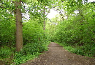
Scratchwood is an extensive, mainly wooded, country park in Mill Hill in the London Borough of Barnet. The 57-hectare site is a Site of Metropolitan Importance for Nature Conservation and together with the neighbouring Moat Mount Open Space. It is a Local Nature Reserve.

<span class="mw-page-title-main">Coppetts Wood and Scrublands</span> Nature reserve in the London Borough of Barnet

Coppetts Wood and Scrublands is a 14.5-hectare (36-acre) Site of Borough Importance for Nature Conservation, Grade I, between Muswell Hill and Friern Barnet in the London Borough of Barnet. It is part of the Coppetts Wood and Glebelands Local Nature Reserve.

<span class="mw-page-title-main">Oak Hill Wood</span>

Oak Hill Wood is a 10-hectare Local Nature Reserve (LNR) and a Site of Borough Importance for Nature Conservation Grade I, in East Barnet, London. It is owned by the London Borough of Barnet, and part of it is a 5.5-hectare nature reserve managed by the London Wildlife Trust.

<span class="mw-page-title-main">Monken Hadley Common</span> Nature Reserve in Barnet, London

Monken Hadley Common lies within the Monken Hadley Conservation Area, and is listed as a “Site of Borough Importance for Nature Conservation, Grade I,” by the London Borough of Barnet. It is registered common land, and it is owned by the Trustees of Monken Hadley Common.

<span class="mw-page-title-main">Bells Hill Burial Ground</span>

Bells Hill Burial Ground is a cemetery and Site of Local Importance for Nature Conservation in the Parish of Chipping Barnet in the London Borough of Barnet. It was opened in 1895 and closed in 2005 when it officially became full. In 2006 control was passed to Barnet Council. There is access from Spring Close.

<span class="mw-page-title-main">Big Wood and Little Wood</span> Small forested areas in London, England

Big Wood and Little Wood are two patches of woodland in Hampstead Garden Suburb in the London Borough of Barnet. They are a Site of Borough Importance for Nature Conservation, Grade 1, and a Local Nature Reserve. Big Wood is 7.3 hectares and Little Wood is 1.2 hectares.

<span class="mw-page-title-main">St John the Baptist Church, Chipping Barnet</span> Church in Greater London, England

St John the Baptist Church is the Church of England parish church of Chipping Barnet, Greater London. It forms part of the Chipping Barnet Team Ministry, comprising St Mark's, Barnet Vale, St Peter's, Arkley and St Stephen's, Bell's Hill. It crowns the ascent up Barnet Hill, and stands at the junction of Wood Street and High Street. It is one of the few Anglican churches in Greater London to belong to the Diocese of St Albans.

<span class="mw-page-title-main">Ravenscroft Cottages</span>

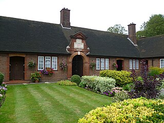
The Ravenscroft Cottages, also known as Jesus Hospital, are grade II listed almshouses in Wood Street, Chipping Barnet. The houses were built in 1672 but rebuilt in the 19th century.

<span class="mw-page-title-main">Eleanor Palmer</span>

Eleanor Palmer was an English philanthropist who established a charity to help the poor of Chipping Barnet and Kentish Town, now parts of London. Her charity still exists and owns and runs almshouses and residential homes for the elderly.

James Ravenscroft was a lawyer, merchant, and philanthropist in Chipping Barnet, in what is now north London.

References

  1. Chipping Barnet. British Library. Retrieved 3 July 2021.
  2. Sheet 45. Map of Hertfordshire. Originally published by Ordnance Survey, Southampton, 1873–1885. British History Online. Retrieved 13 July 2021.
  3. 1 2 3 4 5 6 Barnet Common and Physic Well. London Borough of Barnet. Retrieved 10 July 2021.
  4. Willey, Russ. (2006) Chambers London Gazetteer. London: Chambers. p. 25. ISBN 9780550102591
  5. 1 2 History Of The Eleanor Palmer Trust. Eleanor Palmer Trust, 2019. Retrieved 11 July 2021.
  6. 1 2 Ravenscroft Gardens. London Gardens Trust. Retrieved 14 July 2021.
  7. 1 2 Hewlett, Jan; Ian Yarham & David Curson. (1997) Nature Conservation in Barnet. Ecology Handbook No. 28. London: London Ecology Unit. p. 10. ISBN 1871045274
  8. 1 2 Barnet Hospital. Lost Hospitals of London. Retrieved 13 July 2021.
  9. Mays Lane and Duck Island. London Borough of Barnet. Retrieved 13 July 2021.
  10. Thorne, James. (1876). Handbook to the Environs of London. Vol. Part 1. London: John Murray. p. 29.
  11. "How Barnet got its Railways" by M. A. Rose in W. H. Gelder (Ed.) (2002) Historic Barnet. 5th edition. Barnet: Barnet & District Local History Society. pp. 96–106 (p. 105). ISBN 0951334247
  12. Ravenscroft Gardens (also known as Barnet Common, Barnet Recreation Ground). Parks and Gardens. Retrieved 14 July 2021.
  13. Hewlett et al, pp. 88–89.
  14. 1 2 3 4 5 "Barnet's Physic Well" by Brian Wise in W. H. Gelder (Ed.) (2002) Historic Barnet. 5th edition. Barnet: Barnet & District Local History Society. pp. 49–54. ISBN 0951334247
  15. 1 2 Historic ‘healing’ well of Barnet restored. London Borough of Barnet, 21 November 2018. Retrieved 13 July 2021.
  16. Historic England. "Barnet Physic Well (1064804)". National Heritage List for England . Retrieved 1 August 2023.

51°38′38″N0°13′26″W / 51.644°N 0.224°W / 51.644; -0.224