Finchley is a large district of north London, England, in the London Borough of Barnet. Finchley is on high ground, 7 mi (11 km) north of Charing Cross. Nearby districts include: Golders Green, Muswell Hill, Friern Barnet, Whetstone, Mill Hill and Hendon.

Totteridge is a residential area and former village in the London Borough of Barnet, England. It is a mixture of suburban development and open land situated 8 miles (13 km) north north-west of Charing Cross. It is part of the Whetstone postal district (N20).

The London Borough of Barnet is a local authority area on the northern outskirts of London. The borough was formed in 1965 from parts of the ceremonial counties of Middlesex and Hertfordshire. It is the second largest London borough by population with 389,344 inhabitants as of 2021, also making it the 17th largest district in England. The borough covers an area of 86.74 square kilometres (33 sq mi), the fourth highest of the 32 London boroughs, and has a population density of 45.8 people per hectare, which ranks it 25th.

East Finchley is an area in North London, immediately north of Hampstead Heath. Like neighbouring Muswell Hill, it straddles the London Boroughs of Barnet and Haringey, with most of East Finchley falling into the London Borough of Barnet. It has the greenest high road in London.

North Finchley is a suburb of London in the London Borough of Barnet, situated 7 miles (11 km) north-west of Charing Cross. North Finchley is centred on Tally Ho Corner, the junction of the roads to East Finchley, Church End, Friern Barnet and Whetstone. Church End is often known as Finchley Central, owing to the name of the tube station located there.

Colindale is a London Underground station in Colindale, a suburb of north-west London. The station is on the Edgware branch of the Northern line, between Burnt Oak and Hendon Central stations, and is in Travelcard Zone 4.

Totteridge & Whetstone is a London Underground station in Whetstone in the London Borough of Barnet, North London. It is on the High Barnet branch of the Northern line, between High Barnet and Woodside Park stations, in Travelcard Zone 4. It was first built in 1872.

Woodside Park is a London Underground station in Woodside Park, north London.
West Hendon is a district of Hendon in North London, in the London Borough of Barnet. It is the NW9 part of Hendon, located around the A5 Edgware Road and the Welsh Harp. The area is known for the West Hendon Estate which is undergoing controversial regeneration.

Chipping Barnet is a constituency created in 1974 and represented in the House of Commons of the UK Parliament since 2005 by Theresa Villiers of the Conservative Party. It is part of the London Borough of Barnet, on the border with Hertfordshire.

Woodside Park is a suburban residential area in the London Borough of Barnet, in the North Finchley postal district of N12.

Friern Barnet is a suburban area within the London Borough of Barnet, 7.4 miles (11.9 km) north of Charing Cross. Its centre is formed by the busy intersection of Colney Hatch Lane, Woodhouse Road and Friern Barnet Road.
Friern Barnet Urban District was a local government area in Middlesex, England created in 1883 from the civil parish Friern Barnet. It was succeeded by the London Borough of Barnet in 1965 as one of the smaller of its contributory predecessor districts. It was at the local level governed for 11 years by a local board, then by Friern Barnet Urban District Council which operated primarily with separate functions from the County Council, operating occasionally for major planning decisions and major projects together with that body, Middlesex County Council.
Oakleigh Park is a loosely defined district in the north of the London Borough of Barnet. It adjoins Whetstone, and is often regarded either as part of that or of East Barnet, although the East Coast Main Line forms a border with the latter. The name is a relatively modern invention, after the eponymous station which opened in 1873. Since 2002 'Oakleigh' has also been the name of the electoral ward for the area, formed from parts of the abolished Hadley and Friern Barnet wards.

Finchley Catholic High School is a boys' secondary school with a coeducational sixth form in North Finchley, part of the London Borough of Barnet, England. The current head teacher is Niamh Arnull, who had previously been a member of the teaching staff in the 1990s.

The Dollis Valley Greenwalk is a footpath route in the London Borough of Barnet in London, England, between Moat Mount Nature Reserve in Mill Hill and Hampstead Heath. The route is designed to act as a link between the Capital Ring and the London Loop, and between the many green spaces and wildlife corridors along the way. It is approximately 10 miles (16 km) long. It mainly follows the Dollis Brook and is one of the many parks and open spaces in Barnet.

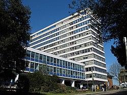
Barnet London Borough Council, also known as Barnet Council, is the local authority for the London Borough of Barnet in Greater London, England. It is a London borough council, one of 32 in London. The council has been under Labour majority control since 2022. The council meets at Hendon Town Hall and has its main offices at 2 Bristol Avenue in Colindale.

Joseph Baxendale (1785–1872) was an English entrepreneur, known for rebuilding and expanding the Pickfords carrier company in the middle of the 19th century.

Sydney Simmons was an English entrepreneur and philanthropist in Okehampton, Devon, and Friern Barnet, Middlesex. Born in Devon, he was first apprenticed to a drapery company before travelling to London in 1862 where he became the North American representative of a carpet company. He acquired the rights to a new carpet cleaning process, the exploitation of which in Britain made him wealthy. He lived in Friern Barnet and funded a number of philanthropic projects there and in his native Okehampton where he was buried.

2 Bristol Avenue is a municipal building in Bristol Avenue, Colindale, London. It is the administrative headquarters of Barnet London Borough Council.