Gmina Kamionka Wielka is a rural gmina in Nowy Sącz County, Lesser Poland Voivodeship, in southern Poland. Its seat is the village of Kamionka Wielka, which lies approximately 9 kilometres (6 mi) south-east of Nowy Sącz and 82 km (51 mi) south-east of the regional capital Kraków.

Podole-Górowa is a village in the administrative district of Gmina Gródek nad Dunajcem, within Nowy Sącz County, Lesser Poland Voivodeship, in southern Poland. It lies approximately 6 kilometres (4 mi) east of Gródek nad Dunajcem, 16 km (10 mi) north-east of Nowy Sącz, and 70 km (43 mi) south-east of the regional capital Kraków.

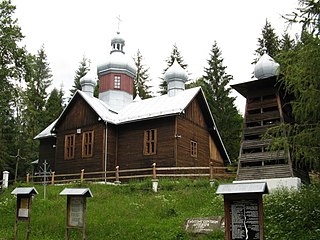
Kamionka Mała is a village in the administrative district of Gmina Kamionka Wielka, within Nowy Sącz County, Lesser Poland Voivodeship, in southern Poland. It lies approximately 8 kilometres (5 mi) south-east of Nowy Sącz and 81 km (50 mi) south-east of the regional capital Kraków.

Polany is a village in the administrative district of Gmina Krynica-Zdrój, within Nowy Sącz County, Lesser Poland Voivodeship, in southern Poland, close to the border with Slovakia. It lies approximately 14 kilometres (9 mi) north of Krynica-Zdrój, 23 km (14 mi) south-east of Nowy Sącz, and 96 km (60 mi) south-east of the regional capital Kraków.
Czaczów is a village in the administrative district of Gmina Łabowa, within Nowy Sącz County, Lesser Poland Voivodeship, in southern Poland. It lies approximately 5 kilometres (3 mi) west of Łabowa, 13 km (8 mi) south-east of Nowy Sącz, and 86 km (53 mi) south-east of the regional capital Kraków.
Kamianna is a village in the administrative district of Gmina Łabowa, within Nowy Sącz County, Lesser Poland Voivodeship, in southern Poland. It lies approximately 6 kilometres (4 mi) east of Łabowa, 21 km (13 mi) south-east of Nowy Sącz, and 94 km (58 mi) south-east of the regional capital Kraków.
Kotów is a village in the administrative district of Gmina Łabowa, within Nowy Sącz County, Lesser Poland Voivodeship, in southern Poland. It lies approximately 3 kilometres (2 mi) south-east of Łabowa, 18 km (11 mi) south-east of Nowy Sącz, and 91 km (57 mi) south-east of the regional capital Kraków.
Krzyżówka is a village in the administrative district of Gmina Łabowa, within Nowy Sącz County, Lesser Poland Voivodeship, in southern Poland. It lies approximately 9 kilometres (6 mi) south-east of Łabowa, 25 km (16 mi) south-east of Nowy Sącz, and 97 km (60 mi) south-east of the regional capital Kraków.

Łabowa is a village in Nowy Sącz County, Lesser Poland Voivodeship, in southern Poland. It is the seat of the gmina called Gmina Łabowa. It lies approximately 16 kilometres (10 mi) south-east of Nowy Sącz and 90 km (56 mi) south-east of the regional capital Kraków.
Łosie is a village in the administrative district of Gmina Łabowa, within Nowy Sącz County, Lesser Poland Voivodeship, in southern Poland. It lies approximately 9 kilometres (6 mi) south-east of Łabowa, 24 km (15 mi) south-east of Nowy Sącz, and 97 km (60 mi) south-east of the regional capital Kraków.
Maciejowa is a village in the administrative district of Gmina Łabowa, within Nowy Sącz County, Lesser Poland Voivodeship, in southern Poland. It lies approximately 16 kilometres (10 mi) south-east of Nowy Sącz and 89 km (55 mi) south-east of the regional capital Kraków.
Nowa Wieś is a village in the administrative district of Gmina Łabowa, within Nowy Sącz County, Lesser Poland Voivodeship, in southern Poland. It lies approximately 4 kilometres (2 mi) south-east of Łabowa, 19 km (12 mi) south-east of Nowy Sącz, and 92 km (57 mi) south-east of the regional capital Kraków.
Roztoka Wielka is a village in the administrative district of Gmina Łabowa, within Nowy Sącz County, Lesser Poland Voivodeship, in southern Poland. It lies approximately 9 kilometres (6 mi) south-east of Łabowa, 25 km (16 mi) south-east of Nowy Sącz, and 98 km (61 mi) south-east of the regional capital Kraków.
Składziste is a village in the administrative district of Gmina Łabowa, within Nowy Sącz County, Lesser Poland Voivodeship, in southern Poland. It lies approximately 5 kilometres (3 mi) south-west of Łabowa, 15 km (9 mi) south-east of Nowy Sącz, and 88 km (55 mi) south-east of the regional capital Kraków.
Uhryń is a village in the administrative district of Gmina Łabowa, within Nowy Sącz County, Lesser Poland Voivodeship, in southern Poland. It lies approximately 6 kilometres (4 mi) south of Łabowa, 20 km (12 mi) south-east of Nowy Sącz, and 93 km (58 mi) south-east of the regional capital Kraków.
Obidza is a village in the administrative district of Gmina Łącko, within Nowy Sącz County, Lesser Poland Voivodeship, in southern Poland. It lies approximately 8 kilometres (5 mi) south-east of Łącko, 18 km (11 mi) south-west of Nowy Sącz, and 74 km (46 mi) south-east of the regional capital Kraków.
Zarzecze is a village in the administrative district of Gmina Łącko, within Nowy Sącz County, Lesser Poland Voivodeship, in southern Poland. It lies approximately 2 kilometres (1 mi) south-west of Łącko, 22 km (14 mi) west of Nowy Sącz, and 67 km (42 mi) south-east of the regional capital Kraków.

Leluchów is a village in the administrative district of Gmina Muszyna, within Nowy Sącz County, Lesser Poland Voivodeship, in southern Poland, close to the border with Slovakia. It lies approximately 7 kilometres (4 mi) south of Muszyna, 40 km (25 mi) south-east of Nowy Sącz, and 111 km (69 mi) south-east of the regional capital Kraków.
Podrzecze is a village in the administrative district of Gmina Podegrodzie, within Nowy Sącz County, Lesser Poland Voivodeship, in southern Poland. It lies approximately 7 kilometres (4 mi) north-east of Podegrodzie, 5 km (3 mi) south-west of Nowy Sącz, and 73 km (45 mi) south-east of the regional capital Kraków.


