
Sequoyah County is a county located in the U.S. state of Oklahoma. As of the 2020 census, the population was 39,281. The county seat is Sallisaw. Sequoyah County was created in 1907 when Oklahoma became a state. It was named after Sequoyah, who created the Cherokee syllabary and its written language.

Cherokee County is a county located in the U.S. state of Oklahoma. As of the 2020 census, the population was 47,078. Its county seat is Tahlequah, which is also the capital of the Cherokee Nation.

Tenkiller is an unincorporated community and census-designated place (CDP) in Cherokee County, Oklahoma, United States. The population was 390 as of the 2020 Census.

The Saline River, also known as Saline Creek, is a 202-mile-long (325 km) tributary of the Ouachita River in the south central portion of the U.S. state of Arkansas. It is the longest river that flows entirely within the state of Arkansas.

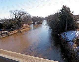
The Illinois River is a 145-mile-long (233 km) tributary of the Arkansas River in the U.S. states of Arkansas and Oklahoma. The Osage Indians named it Ne-eng-wah-kon-dah, which translates as "Medicine Stone River". The state of Oklahoma has designated its portion as a Scenic River.

Tenkiller Ferry Lake, or more simply, Lake Tenkiller, is a reservoir in eastern Oklahoma formed by the damming of the Illinois River. The earth-fill dam was constructed between 1947 and 1952 by the United States Army Corps of Engineers for purposes of flood control, hydroelectric power generation, water supply and recreation. It went into full operation in 1953. The lake and dam were named for the Tenkiller family, prominent Cherokees who owned the land and ferry that were bought for the project. This is the 6th largest lake in Oklahoma, based on water capacity.
The Elk River is a 35.2-mile-long (56.6 km) tributary of the Neosho River in southwestern Missouri and northeastern Oklahoma in the United States. Its tributaries also drain a small portion of northwestern Arkansas. Via the Neosho and Arkansas rivers, the Elk is part of the Mississippi River watershed.

The Salt Fork of the Arkansas River is a 239-mile-long (385 km) tributary of the Arkansas River in southern Kansas and northern Oklahoma in the United States. Via the Arkansas River, it is part of the watershed of the Mississippi River.

The Chikaskia River is a 159-mile-long (256 km) tributary of the Salt Fork of the Arkansas River in southern Kansas and northern Oklahoma in the United States. Via the Salt Fork and Arkansas rivers, it is part of the watershed of the Mississippi River.

The Mulberry River is a 70-mile-long (110 km) tributary of the Arkansas River in northwestern Arkansas in the United States. Via the Arkansas River, it is part of the watershed of the Mississippi River. It has been designated a National Wild and Scenic River. The drainage basin of the Mulberry River has an area of 373 square miles (970 km2) and the annual average mean flow of the river near its mouth is 557 cubic feet per second.

Mountain Fork, also known as the Mountain Fork of the Little River, is a 98-mile-long (158 km) tributary of the Little River in western Arkansas and southeastern Oklahoma in the United States. Via the Little and Red rivers, it is part of the watershed of the Mississippi River. The stream rises in the Ouachita Mountains. Broken Bow Lake is an artificial lake along the course of the Mountain Fork. The stream is known for canoeing, kayaking, and sport fishing, including for stocked trout.
The Medicine Lodge River is a 130-mile-long (210 km) tributary of the Salt Fork of the Arkansas River in southern Kansas and northern Oklahoma in the United States. Via the Salt Fork and Arkansas rivers, it is part of the watershed of the Mississippi River.

The North Fork River or the North Fork of White River is a 109-mile-long (175 km) tributary of the White River, into which it flows near Norfork, Arkansas.

The Little River is a tributary of the Red River, with a total length of 217 miles (349 km), 130 miles (210 km) within the Choctaw Indian Reservation in southeastern Oklahoma and 87 miles (140 km) in southwestern Arkansas in the United States. Via the Red, it is part of the watershed of the Mississippi River. Six large reservoirs impound the Little River and its tributaries. The drainage basin of the river totals 4,204 square miles (10,890 km2), 2,204 square miles (5,710 km2) in Oklahoma and 2,036 square miles (5,270 km2) in Arkansas. The Little River and its upper tributaries are popular for recreational canoeing and kayaking.
Sexton is a former community in Dutch Mills Township, Washington County, Arkansas, United States. The community was located on a tributary of the Baron Fork approximately one-half mile east of the Arkansas - Oklahoma state line.

The Kings River is a tributary of the White River. It rises in the Boston Mountains of Arkansas and flows northward for more than 90 miles into Table Rock Lake in Missouri. The Arkansas portion of the river is undammed and bordered by rural and forested land, the river is popular for paddling and sport fishing.
Caney Creek is a watercourse in Adair County and Cherokee County in Oklahoma. It forms just southeast of Stilwell and travels on an arc generally northwest, west, and then southwest before emptying into Tenkiller Ferry Lake on the Illinois River east of Pettit.
Caney is a census-designated place (CDP) in Cherokee County, Oklahoma, United States, within the Cherokee Nation. It was first listed as a CDP prior to the 2020 census. It includes the unincorporated community of Tailholt.
Etta is a census-designated place (CDP) in Cherokee County, Oklahoma, United States, within the Cherokee Nation. It was first listed as a CDP prior to the 2020 census.
