
The Bay of Fundy is a bay between the Canadian provinces of New Brunswick and Nova Scotia, with a small portion touching the US state of Maine. It has an extremely high tidal range.

Pictou is a town in Pictou County, in the Canadian province of Nova Scotia. Located on the north shore of Pictou Harbour, the town is approximately 10 km north of the larger town of New Glasgow.
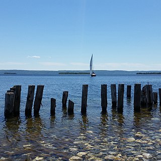
Bras d'Or Lake is an inland sea, or large body of partially fresh/salt water in the centre of Cape Breton Island in the province of Nova Scotia, Canada. Bras d'Or Lake is sometimes referred to as the Bras d'Or Lakes or the Bras d'Or Lakes system; however, its official geographic name is Bras d'Or Lake, as it is a singular entity. Canadian author and yachtsman Silver Donald Cameron describes Bras d'Or Lake as "A basin ringed by indigo hills laced with marble. Islands within a sea inside an island." The lake is connected to the North Atlantic by natural channels; the Great Bras d'Or Channel north of Boularderie Island and the Little Bras d'Or Channel to south of Boularderie Island connect the northeastern arm of the lake to the Cabot Strait. The Bras d'Or is also connected to the Atlantic Ocean via the Strait of Canso by means of a lock canal completed in 1869—the St. Peters Canal, at the southern tip of the lake.

The Minas Basin is an inlet of the Bay of Fundy and a sub-basin of the Fundy Basin located in Nova Scotia, Canada. It is known for its extremely high tides.

Grand Narrows is a community in the Cape Breton Regional Municipality in Nova Scotia, Canada. The community is the birthplace of the longest serving Premier of Nova Scotia, George Henry Murray. The Barra Strait Marina is here, operated by the Grand Narrows Waterfront Development Society.
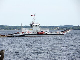
The LaHave River is a 97 km (60 mi) river in Nova Scotia, Canada, running from its source in Annapolis County to the Atlantic Ocean. Along its way, it splits the communities of LaHave and Riverport and runs along the Fairhaven Peninsula and bisects the town of Bridgewater flowing into the LaHave River estuary. Tides affect water levels for about 20 km up the river. There are a number of tourist attractions along the river, and it is also well-used for recreational sailing. As well as two bridges at Bridgewater, the river can be crossed by a cable ferry at the town of LaHave.

The Salmon River is a Canadian river in central Nova Scotia's Colchester County.
The St. Mary's River is a Canadian river. At approximately 250 kilometres (160 mi), it is one of Nova Scotia's longest rivers. It runs through Guysborough County, Antigonish County, Halifax Regional Municipality, Colchester County and Pictou County of Nova Scotia and drains into the Atlantic Ocean at Sonora, Nova Scotia. The river drains an area of approximately 1,350 square kilometres (520 sq mi) and has four branches; the West, East, North and Main. It offers important Atlantic salmon habitat and the riverbanks are a habitat for the wood turtle.
Jeddore is a Canadian rural community in Nova Scotia's Halifax Regional Municipality. The community itself comprises several smaller communities. Often the inner communities are referred to on their own but much of the time simply the encapsulating region of Jeddore is simply used. This is most likely due to the size of the communities, individually they are relatively unknown to residents outside of Nova Scotia's Eastern Shore.
Iona is a small community in the Canadian province of Nova Scotia, located in Victoria County on Cape Breton Island. It is named after Iona in Scotland. Perched above the Barra Strait between the Great Bras d'Or and Piper's Cove portions of Bras d'Or Lake, Iona is the western terminus of the Barra Strait Bridge carrying Nova Scotia Route 223 across to Grand Narrows village. The Cape Breton and Central Nova Scotia Railway passes through the village, crossing the Barra Strait over the Grand Narrows Bridge on its way east to North Sydney and Sydney.
Greenfield is a small rural community in the Canadian province of Nova Scotia, located in Colchester County. It is two miles south of the Salmon River and six miles east of Truro, NS. The name is intended to describe the landscape, annotated by surveyor Alexander Miller around 1817.
Grand River is a small town in the Canadian province of Nova Scotia, located in Richmond County. Its geographical coordinates are 45° 38' 0" North, 60° 40' 0" West
Salmon River Lake is a small community in the Canadian province of Nova Scotia, located in the Municipality of the District of Guysborough in Guysborough County.
Big Beach is a community located on the north side of the Boisdale Hills on the east side of the Great Bras D'Or Lake on Provincial Route 223, which runs from Leitches Creek to Little Narrows, through Central Cape Breton Island in the Canadian province of Nova Scotia. Located on the "Bras D'Or Lakes Scenic Drive" it is part of the Cape Breton Regional Municipality in Central Cape Breton Island.
Salmon River Road is a community in the Canadian province of Nova Scotia, located in the Cape Breton Regional Municipality on Cape Breton Island.
Soldiers Cove is a small community in the Canadian province of Nova Scotia, located in Richmond County on Cape Breton Island. It's named after veterans of the War of 1812 who settled in the area.
Salmon River is a small community in the Canadian province of Nova Scotia, located in Richmond County.

The Barra Strait is a 1.22 km (0.76 mi) wide channel located the Canadian province of Nova Scotia. It connects the northern and southern basins of Bras d'Or Lake, an inland saltwater body that dominates the centre of Cape Breton Island. The border between two of Cape Breton Island's counties runs through the strait; the community of Grand Narrows, in Cape Breton County, is situated on the eastern shore while the community of Iona, in Victoria County is situated on the western shore.
Pictou Harbour is a natural harbour in Nova Scotia on the Northumberland Strait.


