Barrali

Last updated
Barrali
Comune di Barrali
Barrali-Stemma.png
Coat of arms
Location of Barrali
Italy provincial location map 2015.svg
Red pog.svg
Barrali
Location of Barrali in Sardinia
Italy Sardinia location map IT.svg
Red pog.svg
Barrali
Barrali (Sardinia)
Coordinates: 39°28′N9°6′E / 39.467°N 9.100°E / 39.467; 9.100
Country Italy
Region Sardinia
Province South Sardinia
Government
  MayorFausto Piga
Area
  Total11.5 km2 (4.4 sq mi)
Elevation
140 m (460 ft)
Population
(30 November 2010 [1] )
  Total1,122
  Density98/km2 (250/sq mi)
Demonym(s) Barralesi
Time zone UTC+1 (CET)
  Summer (DST) UTC+2 (CEST)
Postal code
09040
Dialing code 070
Website Official website

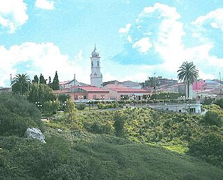
Barrali is a comune (municipality) in the Province of South Sardinia in the Italian region Sardinia, located in the Trexenta about 30 kilometres (19 mi) north of Cagliari.

<i>Comune</i> third-level administrative divisions of the Italian Republic

The comune is a basic administrative division in Italy, roughly equivalent to a township or municipality.

Province of South Sardinia Province of Italy

The Province of South Sardinia is an Italian province of Sardinia instituted on 4 February 2016. It includes the suppressed provinces of Carbonia-Iglesias and Medio Campidano, great part of the old Province of Cagliari, and two other municipalities.

Italy republic in Southern Europe

Italy, officially the Italian Republic, is a country in Southern and Western Europe. Located in the middle of the Mediterranean Sea, Italy shares open land borders with France, Switzerland, Austria, Slovenia and the enclaved microstates San Marino and Vatican City. Italy covers an area of 301,340 km2 (116,350 sq mi) and has a largely temperate seasonal and Mediterranean climate. With around 61 million inhabitants, it is the fourth-most populous EU member state and the most populous country in Southern Europe.

Barrali borders the following municipalities: Donorì, Ortacesus, Pimentel, Samatzai, Sant'Andrea Frius.

Ortacesus Comune in Sardinia, Italy

Ortacesus is a comune (municipality) in the Province of South Sardinia in the Italian region Sardinia, located about 35 kilometres (22 mi) north of Cagliari, included in the Trexenta traditional subregion.

Pimentel, Sardinia Comune in Sardinia, Italy

Pimentel, Pramantellu in Sardinian language, is a comune (municipality) in the Province of South Sardinia in the Italian region Sardinia, located about 30 kilometres (19 mi) north of Cagliari. As of 31 December 2004, it had a population of 1,200 and an area of 15.0 square kilometres (5.8 sq mi).

Samatzai Comune in Sardinia, Italy

Samatzai is a town in the province of South Sardinia, located on the fringe of the Campidano in Sardinia (Italy). It is 33 km away from Cagliari. The name derives from Ancient Greek 'samax', which means "rush mat", or from the Mesopotamian god Samas. Either way, Samatzai is believed to have been inhabited since Nuragic times. The main attraction of note is the 15th-century Church of San Giovanni Battista in the town centre, built in an Aragonese-influenced Gothic style. Other churches include the 17th-century Santa Barbara and the ruined San Marco. The Monte Granitico, a former grain silo that is now a library, is known for its unusual floor plan. Samatzai's economy is mainly focused on the primary sector, despite it being home to one of Italy's most prominent cement works. Residents of the town are known as samatzesi, and the town's patron saint is John the Baptist.

Related Research Articles

Villacidro Comune in Sardinia, Italy

Villacidrolisten  is a town and comune in the province of South Sardinia, Sardinia, Italy. In 2005 it has been the administrative seat of the province 'Medio Campidano', together with Sanluri. Since 2016 it is part of the province of South Sardinia.

Olmedo, Sardinia Comune in Sardinia, Italy

Olmedo is a comune (municipality) in the Province of Sassari in the Italian region of Sardinia, located about 170 kilometres (110 mi) northwest of Cagliari and about 15 kilometres (9 mi) southwest of Sassari. As of 31 December 2004, it had a population of 3,041 and an area of 33.7 square kilometres (13.0 sq mi).

Pozzomaggiore Comune in Sardinia, Italy

Pozzomaggiore is a comune (municipality) in the Province of Sassari in the Italian region Sardinia, located about 140 kilometres (87 mi) northwest of Cagliari and about 40 kilometres (25 mi) south of Sassari. As of 31 December 2004, it had a population of 2,871 and an area of 79.4 square kilometres (30.7 sq mi).

Tissi Comune in Sardinia, Italy

Tissi is a comune (municipality) in the Province of Sassari in the Italian region Sardinia, located about 170 kilometres (110 mi) northwest of Cagliari and about 6 kilometres (4 mi) south of Sassari. As of 31 December 2004, it had a population of 2,017 and an area of 10.3 square kilometres (4.0 sq mi).

Orroli Comune in Sardinia, Italy

Orroli, meaning "downy oak" is, a comune (municipality) in the Province of South Sardinia in the Italian region of Sardinia, located about 67.4 kilometres (41.9 mi) north of Cagliari. As of 31 December 2010, it had a population of 2,430 and an area of 75.6 square kilometres (29.2 sq mi). Orroli territory hosts one of the most important nuraghi of Sardinia called Nuraghe Arrubiu, the only intact example of a five-tower nuraghe, one of the dam in the Flumendosa river and the dam of the Mulargia, which gave name to the artificial lake. Within the village there are many hostels and bed and breakfasts organized around old lifestyles and ancient traditions.

Donori Comune in Sardinia, Italy

Donòri is a comune (municipality) in the Province of South Sardinia in the Italian region Sardinia, located about 25 kilometres (16 mi) north of Cagliari. As of 31 December 2004, it had a population of 2,104 and an area of 35.2 square kilometres (13.6 sq mi).

Furtei Comune in Sardinia, Italy

Furtei is a comune (municipality) in the Province of South Sardinia in the Italian region Sardinia, located about 40 kilometres (25 mi) northwest of Cagliari and about 4 kilometres (2 mi) east of Sanluri. As of 31 December 2004, it had a population of 1,657 and an area of 26.1 square kilometres (10.1 sq mi).

Samassi Comune in Sardinia, Italy

Samassi is a comune (municipality) in the Province of South Sardinia in the Italian region Sardinia, located about 35 kilometres (22 mi) northwest of Cagliari and about 9 kilometres (6 mi) south of Sanluri. As of 31 December 2004, it had a population of 5,332 and an area of 42.2 square kilometres (16.3 sq mi).

San Sperate Comune in Sardinia, Italy

San Sperate, Santu Sparau in Sardinian language, is a comune (municipality) in the Province of South Sardinia in the Italian region Sardinia, located about 20 kilometres (12 mi) northwest of Cagliari. As of 31 December 2004, it had a population of 6,982 and an area of 26.2 square kilometres (10.1 sq mi).

SantAndrea Frius Comune in Sardinia, Italy

Sant'Andrea Frius is a comune (municipality) in the Province of South Sardinia in the Italian region Sardinia, located about 30 kilometres (19 mi) north of Cagliari.

SantAnna Arresi Comune in Sardinia, Italy

Sant'Anna Arresi is a comune (municipality) in the Province of South Sardinia in the Italian region of Sardinia, located about 45 kilometres (28 mi) southwest of Cagliari and about 20 kilometres (12 mi) southeast of Carbonia.

Serramanna Comune in Sardinia, Italy

Serramanna, Serra Manna in sardinian language, is a comune (municipality) in the Province of South Sardinia in the Italian region Sardinia, located about 30 kilometres (19 mi) northwest of Cagliari and about 15 kilometres (9 mi) south of Sanluri. As of 31 December 2004, it had a population of 9,443 and an area of 83.9 square kilometres (32.4 sq mi).

Serrenti Comune in Sardinia, Italy

Serrenti is a comune (municipality) in the Province of South Sardinia in the Italian region Sardinia, located about 35 kilometres (22 mi) northwest of Cagliari and about 9 kilometres (6 mi) southeast of Sanluri. As of 31 December 2004, it had a population of 5,125 and an area of 42.8 square kilometres (16.5 sq mi).

Villasor Comune in Sardinia, Italy

Villasor, Biddesorris or Bidda de Sorris in Sardinian language, is a comune (municipality) in the Province of South Sardinia in the Italian region Sardinia, located about 27 kilometres (17 mi) northwest of Cagliari. As of 29 February 2016, it had a population of 6,949 and an area of 86.6 square kilometres (33.4 sq mi).

Castiadas Comune in Sardinia, Italy

Castiadas is a comune (municipality) in the Province of South Sardinia in the Italian region Sardinia, located about 35 kilometres (22 mi) east of Cagliari. Founded in the 14th century and repopulated in the 19th century after centuries of abandonment, it is part of the Sarrabus-Gerrei historical region. The area was populated by italian-tunisians, mainly of sicilian descent, immigrated here from Bizerte in 1965.

Narbolia Comune in Sardinia, Italy

Narbolia is a comune (municipality) in the Province of Oristano in the Italian region Sardinia, located about 100 kilometres (62 mi) northwest of Cagliari and about 15 kilometres (9 mi) north of Oristano. As of 31 December 2016, it had a population of 1,784 and an area of 40.5 square kilometres (15.6 sq mi). This comune is famous in Sardinia for the "Zippole"; a typical food for carnival in Italian "carnevale". There is an 18-hole golf course set in the pine forest with a five star hotel with a beach 6 kilometres (4 mi) long.

Metropolitan cities of Italy administrative division of Italy

The metropolitan city is an administrative division of Italy, operative since 2015. The metropolitan city, as defined by law, includes a large core city and the smaller surrounding towns that are closely related to it with regard to economic activities and essential public services, as well as to cultural relations and to territorial features.

References

  1. All demographics and other statistics: Italian statistical institute Istat.