Related Research Articles

The Wingecarribee River, a perennial river that is part of the Hawkesbury–Nepean catchment, is located in the Southern Highlands region of New South Wales, Australia.

Mungindi is a town and locality on the border of New South Wales (NSW) and Queensland, Australia. The town is within Moree Plains Shire in New South Wales. Within Queensland, the locality is split between the Shire of Balonne and the Goondiwindi Region with the town in the Shire of Balonne. It possesses a New South Wales postcode. Mungindi sits on the Carnarvon Highway and straddles the Barwon River which is the border between New South Wales and Queensland. At the 2016 census, Mungindi had a population of 601 on the New South Wales side, while the population on the Queensland side was 146.

The Wollondilly River, an Australian perennial river that is part of the Hawkesbury–Nepean catchment, is located in the Southern Tablelands and Southern Highlands regions of New South Wales. The river meanders from its western slopes near Crookwell, flowing south-east through Goulburn, turning north-east to near Bullio, flowing north-west to Barrallier, before finally heading north-easterly into its mouth at Lake Burragorang.

Prestons is a suburb of Sydney, in the state of New South Wales, Australia 37 kilometres south-west of the Sydney central business district, in the local government area of the City of Liverpool.

Menangle is a village in the Macarthur region of New South Wales, Australia.

Wollondilly Shire is a periurban local government area adjacent to the south-western fringe of Sydney, parts of which fall into the Macarthur, Blue Mountains and Central Tablelands regions in the state of New South Wales, Australia. Wollondilly Shire was created by proclamation in the NSW Government Gazette on 7 March 1906, following the passing of the Local Government (Shires) Act 1905, and amalgamated with the Municipality of Picton on 1 May 1940.

Francis Louis Barrallier was a French-born explorer of Australia.

The Wombeyan Caves Road is a New South Wales country road linking Mittagong near the Hume Highway in the east to the Goulburn-Oberon Road at the locality of Richlands in the west. The road is designated as Main Road 258.
Aberdare is a suburb of Cessnock, a large town based on coal mining in the Lower Hunter Region, New South Wales, Australia. Aberdare is a small suburb just 15 minutes’ from beautiful wine country, 45 minutes to Newcastle and two hours to Sydney. George Brown found coal in the area in 1800's.Coal mining created the land boom of 1903-23 and by 1926 Cessnock had a population of 12,000 within a one-mile radius

The Oaks is a town in the Macarthur Region of New South Wales, Australia in Wollondilly Shire on the south western edge of the Sydney Basin. The Oaks is located 76 kilometres (47 mi) south-west of Sydney via the Hume Highway, 13 kilometres (8 mi) west of Camden and 290m above sea-level. At the 2016 census, The Oaks and the surrounding area had a population of 2,525.

Postcodes in Australia are used to more efficiently sort and route mail within the Australian postal system. Postcodes in Australia have four digits and are placed at the end of the Australian address, before the country. Postcodes were introduced in Australia in 1967 by the Postmaster-General's Department and are now managed by Australia Post, Australia's national postal service. Postcodes are published in booklets available from post offices or online from the Australia Post website.
The Kowmung River, a perennial river that is part of the Hawkesbury-Nepean catchment, is located in the Central Tablelands region of New South Wales, Australia.
Murruin Creek is a river of the state of New South Wales in Australia. It is a tributary of the Wollondilly River and part of the Hawkesbury-Nepean catchment.
The Paddys River, a perennial river that is part of the Hawkesbury-Nepean catchment, is located in the Southern Highlands region of New South Wales, Australia.
The Tonalli River, a perennial river that is part of the Hawkesbury-Nepean catchment, is located in the Blue Mountains region of New South Wales, Australia.

Abermain is a town 8 km ENE of Cessnock and 3 km west of Weston, in New South Wales, Australia. Abermain is adjacent to Werakata National Park.
Big Hill is a bounded rural locality in Upper Lachlan Shire to the north of Marulan in the Southern Tablelands of New South Wales, Australia. At the 2016 census, it had a population of 44.

Naradhan is a village and locality in the Central West region of New South Wales Australia. The locality is 452 kilometres (281 mi) from Sydney, the state capital. Naradhan is within the Bland Shire local government area. The village was proclaimed in 1930, and features a shop, primary school, public hall, and the now disused railway station. The town was named after Naradhan a grazing run that was in turn probably named for the Wiradjuri term "ngarradan" meaning "bat".
The Little River, a perennial river that is part of the Hawkesbury-Nepean catchment, is located in the Southern Highlands region of New South Wales, Australia.
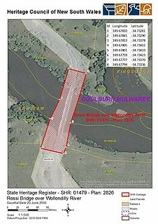
The Rossi Bridge over Wollondilly River is a heritage-listed road bridge that carries Range Road across the Wollondilly River, Goulburn, New South Wales, Australia. The bridge is owned by Transport for NSW. It is also known as Rossi's Crossing. It was added to the New South Wales State Heritage Register on 20 June 2000.
References
- ↑ "Barrallier". Geographical Names Board. NSW Government. Retrieved 23 January 2022.
- ↑ "BARRALLIER". Camden News , (NSW : 1895 - 1954). 2 March 1916. p. 3. Retrieved 23 January 2022.
- ↑ Barrallier Postcode Australia Post
- 1 2 Ford, Geoff (1970). GUNDUNGURA - The Guide. Sydney University Rover Crew. p. 39.
- ↑ Phoenix Auctions History. "View Post Office Details - Barrallier" . Retrieved 12 April 2021.
- ↑ "GEOGRAPHICAL NAMES ACT 1966". Government Gazette of the State of New South Wales (Sydney, NSW : 1901 - 2001). 31 January 1997. p. 324. Retrieved 10 April 2021.
| | This Wingecarribee geography article is a stub. You can help Wikipedia by expanding it. |